
11.05.2023
Europe's newest weather satellite has snapped Earth looking beautiful but ominously cloudy in a high-detailed image of our planet.
Europe's newest weather satellite has snapped an image of the Earth that reveals our planet's incredible beauty, despite gathering clouds.
The image taken by Meteosat Third Generation — Imager 1 (MTG-I1) shows conditions over Europe, Africa, and the Atlantic to an incredible level of detail and demonstrates that the satellite is set to live up to its promise of revolutionizing weather forecasting including the prediction of severe weather.
"This image is a great example of what European cooperation in space can achieve," ESA's Director of Earth Observation Programmes, Simonetta Cheli, said in a statement.(opens in new tab) "The level of detail MTG-I1's image reveals, unachievable over Europe and Africa from a geostationary orbit until now, will give us a greater understanding of our planet and the weather systems that shape it."
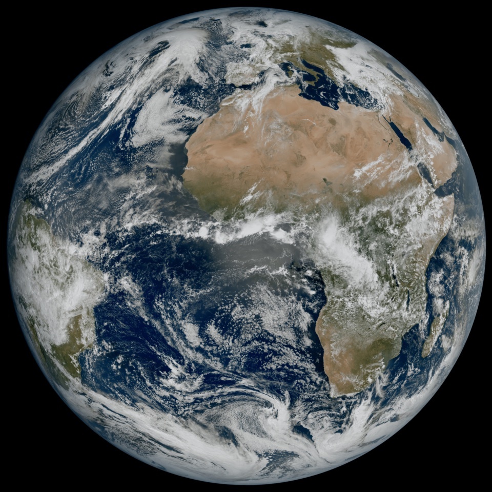
The image of Earth captured by the Meteosat Third Generation — Imager 1 satellite. (Image credit: ESA/Eumetsat )
Launched on Dec. 12, 2022 aboard an Ariane 5 rocket, MTG-I1 represents the first of a new generation of weather satellites, the MTG system, to be operated by Europe's meteorological satellite agency, EUMETSAT, and the European Space Agency (ESA). The full system is set to be operational by 2016 and will consist of six satellites supplying critical data for the early detection of extreme weather events for the next two decades.
The new picture released this week by EUMETSAT and the ESA was taken by the satellite's Flexible Combined Imager on March 18, 2023. It shows a large region of Northern and Western Europe and Scandinavia blanketed in clouds, while Italy and the Western Balkans enjoy relatively clear skies.
Also seen in the image are cloud vortices swirling over the Canary Islands, snow covering the Alps and even sediment in water along the coast of Italy. As ESA notes in a separate release(opens in new tab) comparing these new images with older ones, none of these details are as clearly visible in images from the Meteosat Second Generation satellites which MTG-I1 and its fellow third-generation spacecraft companions will eventually replace. In fact, some of these features have been absent altogether in last-generation satellite images.
MTG-I1 has also demonstrated its capability to observe cloud structures at high latitudes, which will help weather forecasters to track the rapid development of severe weather in these regions of the globe.
"This remarkable image gives us great confidence in our expectation that the MTG system will herald a new era in the forecasting of severe weather events," EUMETSAT director general, Phil Evans, said in ESA's statement. "It might sound odd to be so excited about a cloudy day in most of Europe. But the level of detail seen for the clouds in this image is extraordinarily important to weather forecasters."
The third generation of Meteosat meteorological satellites won't take images only at a higher resolution than that its predecessors, but they will also snap images of the planet more frequently than the instruments of the second generation of satellites. The system will produce images of the full disc of Earthevery 10 minutes once it is fully operational. This frequency will also be important to the MTG system's ability to monitor severe weather.
"The high-resolution and frequent repeat cycle of the Flexible Combined Imager will greatly help the World Meteorological Organization community to improve forecasts of severe weather, long-term climate monitoring, marine applications, and agricultural meteorology, and will make an important contribution to the Early Warnings For All(opens in new tab) Initiative, in particular on the African continent," Head of the World Meteorological Organization Space Systems and Utilization Division, WMO, Natalia Donoho, said in the statement.
MTG-I1 won't be supplying data to meteorological services in Europe and the rest of the globe until the tail end of 2023. Over the next 12 months, its operators will switch on the satellite's Flexible Combined Imager and the Lightning Imager instruments and will calibrate the data it collects.
The MTG-I1 will soon be joined in orbit by a revolutionary MTG Sounding (MTG-S) satellite carrying an Infrared Sounder and an Ultraviolet Visible Near-Infrared spectrometer. MTG-S will allow atmospheric instability to be modeled in three dimensions throughout the clouds, making it a significant step forward for severe thunderstorm early warning.
"Following the launch of the MTG-I1 satellite, the momentum in the MTG program is relentless," ESA's Meteosat program manager Paul Blythe said. "The initial results from MTG-I1 are hugely motivating for those who have worked on the program and create a major impetus to complete the full MTG constellation by 2026."
The MTG-S satellite is expected to be finished by mid-next year and should also be able to provide data regarding ozone, carbon monoxide, and volcanic ash in Earth's atmosphere.
Quelle: SC