
The far side of the Moon and the distant Earth, imaged by the Chang'e-5T1 mission in 2014.

1.11.2018
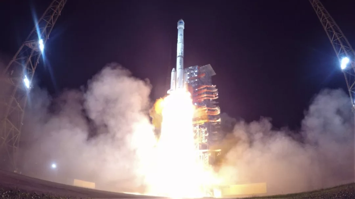
Liftoff of the Long March 3B/YZ-1 carrying the 13th and 14th Beidou-3 satellites on September 19, 2018.CALT
-
China will continue the construction of its Beidou navigation and positioning system on November 1 with the launch of an enhanced Long March 3B to send a new satellite into geosynchronous orbit.
Launch from the Xichang Satellite Launch Centre in southwest China is scheduled to take place around 23:55 local time (15:55 universal time, 11:55 Eastern), according to airspace closure notices issued on October 31.
The event will be the 32nd Chinese orbital launch of 2018, following the Monday launch of the China-France CFOSat and the only failure, private company Landspace's Zhuque-1, on Saturday.
The main contractor for the space programme, the China Aerospace Science and Technology Group (CASC), said at the start of the year it would target around 35 launches and looks on course to reach that goal.
If this Long March 3B launch from Xichang and potentially one further similar mission carrying a pair of Beidou satellites to medium Earth orbit (MEO) in mid-November succeed, China will then proceed with the launch of the pioneering Chang'e-4 lunar far side landing mission in early December.
The far side of the Moon and the distant Earth, imaged by the Chang'e-5T1 mission in 2014. Chinese Academy of Sciences
Thursday's launch could also involve the latest moves towards recovering rocket components, following on from recent tests.
The boosters from the previous Long March 3B launch, on October 15, carried data logging and active tracking equipment for tests to determine the altitude and timing for future parachute landings.
In September CASC also tested the use of a parafoil on the payload fairing with the aim of improving accuracy of its return to Earth so as to prevent debris landing on people and property, as well as potentially eventual reusability.
First footage of China using a parafoil for payload fairing reentry after satellite launch
The Beidou navigation system, which takes its name from the Chinese asterism equivalent to the Plough or Big Dipper, is China's answer to the US Global Positioning System (GPS), Russia's GLONASS and Europe's Galileo GNSS constellations.
The completed system of 35 operational Beidou satellites will have 27 satellites in MEO at around 22,000 km altitude, five in geostationary orbit and three more in inclined geosynchronous orbits at 35,786 km, providing global GNSS coverage with a positioning accuracy of 2.5 metres.
Systems like GPS and Beidou provide civilian applications such as navigation for shipping and road traffic, mapping and surveying, but also assist military forces from space, facilitating targeting, positioning and locating, and the synchronising of operations. The development of Beidou will end previous Chinese military reliance on GPS.
Beidou, also referred to as BDS, is considered a project of national significance and part of the country's national security, economic and social development.

A range of Beidou applications according to the China Navigation Satellite Office. CNSO
Quelle: gbtimes