Note: Updated Monday with improved forecast details
CAPE CANAVERAL — Meteorologists are anticipating favorable odds of good weather during the countdown to launch an Atlas 5 rocket and U.S. military satellite on Thursday evening from Cape Canaveral.
The day’s 40-minute launch opportunity that is timed to deliver the satellite into the correct orbital position opens at 7:46 p.m. EST (0046 GMT).
The United Launch Alliance booster will deploy the Space Base Infrared System Geosynchronous Earth Orbit satellite No. 3, or SBIRS GEO Flight 3, to provide missile detection and early-warning notices of incoming threats.
The Air Force’s 45th Weather Squadron at the Cape predicts an 80 percent chance of acceptable launch conditions. The only area of concern for launch will be cumulus clouds.
The specifics for the launch window include scattered low-level and broken high-level clouds, good visibility, winds from the east at 8 to 12 knots, a relative humidity of 80 percent and a temperature of 71 degrees F.
“On launch day, a weak surface trough pushes into Central Florida with a gradual increase in moisture through the day. There is a slight threat of isolated showers mid to late afternoon. Westerly winds in the steering levels will bring any interior showers toward the east coast. Near sunset and with the loss of diurnal heating, the limited shower threat trends down.,” Air Force meteorologists said Monday.
“The primary concern for launch is cumulus clouds.”
In the event of a 24-hour delay, the forecast for Friday evening calls for increasing clouds in the mid- and upper-levels are expected as another surface trough approaches Florida’s Big Bend area, meteorologists say.
There is a 70 percent chance of acceptable launch conditions on Friday due to cumulus clouds and cloud thickness.
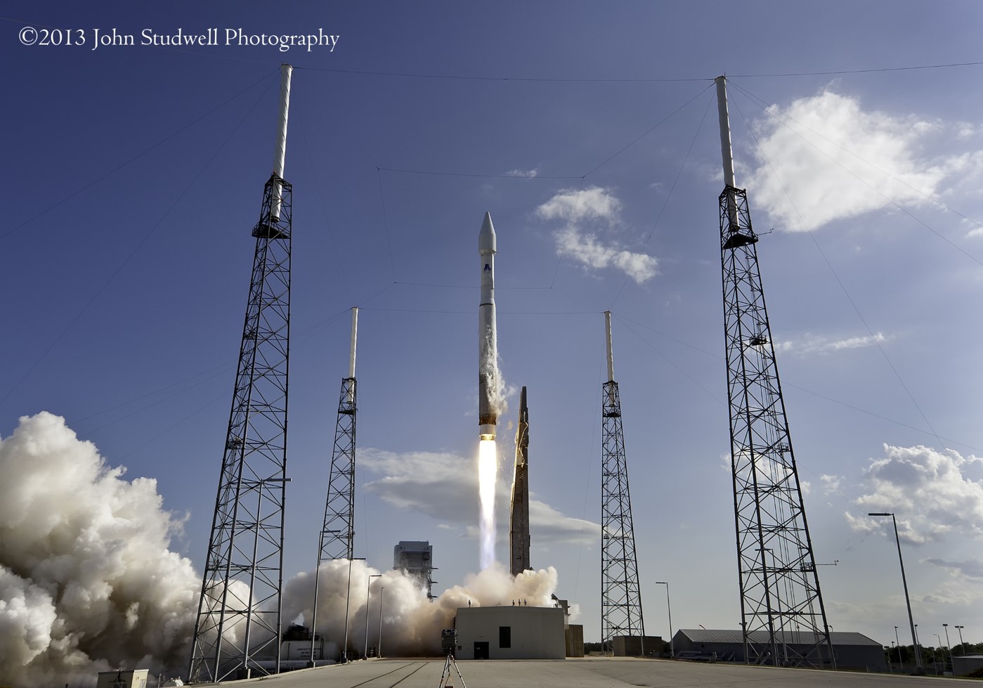
The flight will originate from Complex 41, and the rocket will be rolled from its assembly building to the pad on Wednesday morning.
Public viewing options for the evening launch are somewhat limited given the timing of liftoff.
The optimal spot — Playalinda Beach– closes at sundown, nearly two hours before the launch window opens.
That leaves the Kennedy Space Center Visitor Complex as having the closest available spots. Its main campus 7.1 miles away (although without a direct view of the pad) and the Apollo/Saturn V Center located 5.4 miles away. Either site has admission fees, however.
The nearest free public viewing location offering the best view is Route 401 in Port Canaveral, some 11.7 miles from the launch pad.
Viewing options are described by LaunchPhotography.com.
Get directions there.
The Atlas 5 will generate 860,000 pounds of thrust from its main engine, rising on a pillar of fire to lift the 10,000-pound SBIRS GEO Flight 3 satellite into space.
The rocket will head due east from the Cape en route to a geosynchronous transfer orbit.
It will be the year’s first launch from Cape Canaveral.
Quelle: SN
-
Update: 17.01.2017
.
Atlas V Rocket Glitch Delays Mission From Vandenberg Air Force Base
West Coast launch planned for Jan. 26 is under review as United Launch Alliance works to resolve booster issue


A second-stage booster issue will delay the Atlas V rocket launch planned for later this month from Vandenberg Air Force Base.
United Launch Alliance, which manufactures the Atlas V rocket, announced Monday that the launch date is under review.
“The team is actively working to resolve Atlas V second stage booster issues discovered during vehicle testing,” ULA officials said. “This additional time will allow the ULA team to ensure all systems are operating nominally prior to launch.”
The Atlas V rocket blasts off from Space Launch Complex-3 East on South Base.
Riding on board the Atlas V rocket will be a top-secret payload for the National Reconnaissance Office, which does not release details about its spacecraft.
A new launch date will be released once it’s established, ULA officials said.
The glitch delaying the West Coast mission will not postpone an Atlas V mission from the East Coast.
ULA officials also said the Atlas V mission to carry the Space Based Infrared System (SBIRS), a missile warning satellite, remains on schedule for Thursday from Cape Canaveral Air Force Station in Florida, pending final vehicle verifications.
The Atlas launch was set to be the second last of 2017 from Vandenberg, following the successful Falcon 9 mission to carry 10 Iridium satellite into orbit Saturday morning.
Quelle: Noozhawk
-
Update: 18.01.2017
.
CAPE CANAVERAL, Fla., The U.S. Air Force and Lockheed Martin (NYSE: LMT) will launch the next Space Based Infrared System (SBIRS) satellite on Jan. 19 aboard a United Launch Alliance Atlas V rocket. The launch window is between 7:46 and 8:26 p.m. EST.

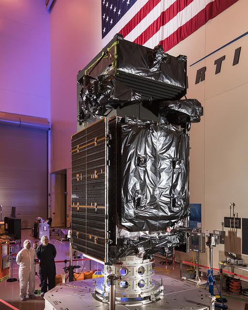
SBIRS GEO Flight 3 was designed and built at Lockheed Martin in Sunnyvale, California, as the next in a series of Air Force satellites that provide multi-mission surveillance in the areas of missile warning, missile defense, technical intelligence and battlespace awareness. The data provided by SBIRS can also be applied to a number of qualified government and civilian applications, including first response for natural disasters and firefighting.
Watch Live: A live launch broadcast will begin at 7:26 p.m. EST and will be viewable at www.ulalaunch.com. Downloadable images and video b-roll of the satellite are available at www.lockheedmartin.com/sbirs.
"At Lockheed Martin, we understand the Air Force's important mission to protect our nation and allies around the world, as well as the critical role that SBIRS plays in their continued ability to respond to evolving threats," said David Sheridan, vice president of Lockheed Martin's Overhead Persistent Infrared systems mission area. "With the launch of GEO Flight 3, we are proud to further enhance SBIRS infrared surveillance capabilities, and we look forward to working with our customer and industry teammates toward 100 percent mission success."
Once it reaches Geosynchronous Earth Orbit—around 22,000 miles above the Earth—GEO Flight 3 will use powerful sensors and cameras to detect and track infrared events, such as missile launches or other heat-causing events. While some satellites can only "see" what is directly below them, the SBIRS constellation has a view of the whole world, scanning for wide-area surveillance and staring at spots of interest.
With each satellite build, Lockheed Martin has continued to streamline its manufacturing process and increase efficiencies, while also introducing innovations that will keep SBIRS relevant long into the future. The next satellite, GEO Flight 4, will undergo final assembly, integration and test prior to its planned 2017 launch. SBIRS GEO-5 and GEO-6, which are currently in production, incorporate a new common spacecraft bus, Lockheed Martin's modernized A2100, which dramatically reduces costs and cycle times while increasing the potential to incorporate future advanced sensor suites.
The SBIRS development team is led by the Remote Sensing Systems Directorate at the U.S. Air Force Space and Missile Systems Center, Los Angeles Air Force Base, California. Lockheed Martin Space Systems, Sunnyvale, California, is the SBIRS prime contractor, with Northrop Grumman Aerospace Systems, Azusa, California, as the payload integrator. The 460th Space Wing, Buckley Air Force Base, Colorado, operates the SBIRS system.
About Lockheed Martin
Headquartered in Bethesda, Maryland, Lockheed Martin is a global security and aerospace company that employs approximately 98,000 people worldwide and is principally engaged in the research, design, development, manufacture, integration and sustainment of advanced technology systems, products and services.
Quelle: Lockheed Martin
---
Russian Techs In ASOC To Monitor SBIRS GEO 3 Launch Jan 19
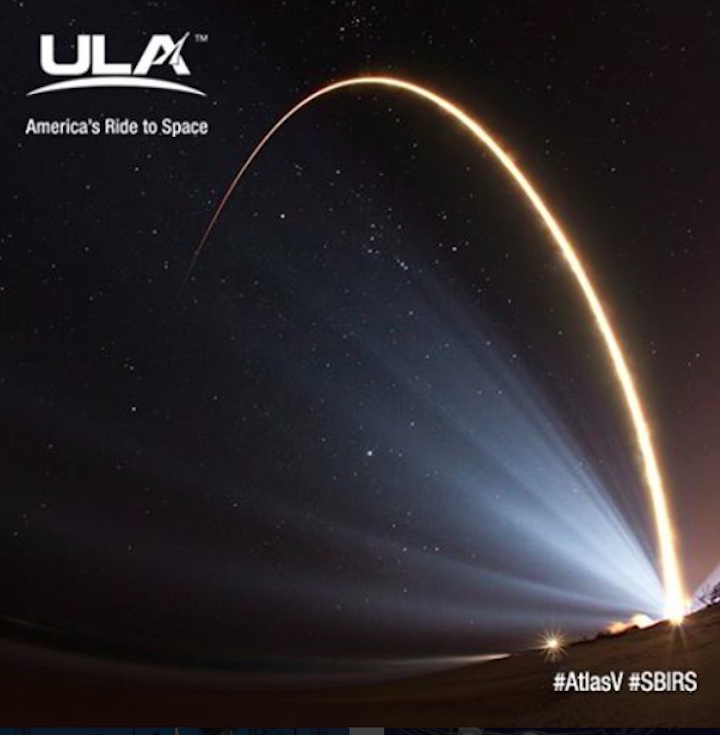
A ULA Atlas V rocket launching SBIRS GEO 2. Photo Credit: John Studwell / AmericaSpace
As U.S. / Russian intelligence controversies swirl between the two countries, a team of Russian rocket technicians will be at Cape Canaveral Air Force Station on Jan. 19 to monitor real time engine data from a United Launch Alliance (ULA) Atlas-V rocket as it lofts the third U.S. Air Force Space Based Infrared System (SBIRS) Geosynchronous Orbit (GEO-3) missile warning satellite into orbit.
This new $1.2 billion, 2-ton spacecraft, intended for hemispheric monitoring, is scheduled for liftoff at 7:46 p.m. EDT at the start of a 40 minute launch window.
Follow our SBIRS GEO-3 Launch Tracker for regular updates and LIVE COVERAGE on launch day!
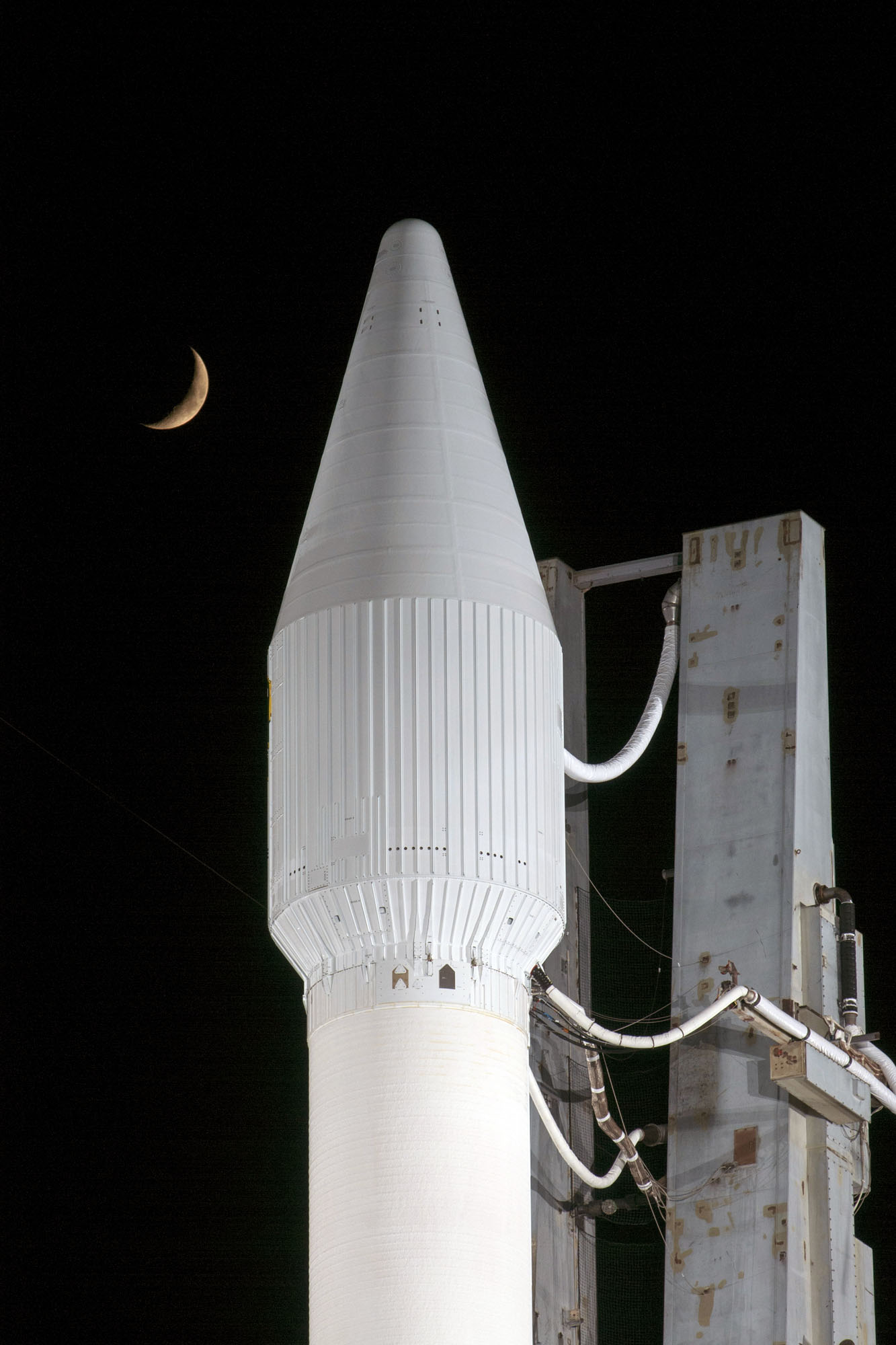
SBIRS GEO-3 missile warning satellite. Photo Credit: Lockheed Martin
In addition several Highly Elliptical Orbit (HEO) missile warning SBIRS payloads with similar sensors have been launched piggyback on other classified U.S. military satellites to specifically monitor northern latitudes.
The use of Russian rocket engines on Atlas V’s flying U.S. military space missions caused a major debate in Congress last year, but continued use of the Russian engine won out over a U.S. replacement because of cost and schedule considerations. The issue could come up again under the new Trump Presidential Administration.
“SBIRS is considered one of the nation’s highest priority space programs,” said Bob Winn, United Launch Alliance’s Air Force program manager.
Locked in their own computer control room in the ULA Atlas Spaceflight Operations Center (ASOC), the Russian team will monitor the real time engine parameters of the Russian Energomash RD-180 engine that will power the Atlas V.
The team has also participated in monitoring RD-180 engine checks at the Cape, and with escorts, can gain access inside of the Atlas V engine compartment that extends about 15 ft. from the base of the rocket on Launch Complex 41.
According to the Air Force and ULA such a Russian Energomash team has been at the Cape for many, but not all Atlas V missions.
The Atlas 401 version, with no solid rocket boosters. is to place the Lockheed Martin spacecraft into a 22,237 x 115 mi. transfer orbit that will be circularized in geosynchronous orbit by several firings of the satellite’s liquid apogee engine.
Earlier USAF Defense Support Program (DSP) scanning infrared missile warning spacecraft were able to detect about 8,000 “infrared events” per year including about 200 larger missile launches.
But with SBIRS HEO and GEO spacecraft retiring the DSPs, the USAF is now able to track dimmer targets with shorter engine burn times. The Missile Defense Agency has over the last five years been able to see about 1,200 additional ballistic missiles, and 5,900 smaller rocket systems in the Middle East and Asia areas outside of NATO, Russia and China compared with earlier capabilities.
“Hundreds of [these] launchers and missiles are currently in range of our deployed forces,” said USAF Col. Dennis Bythewood, director of the Remote Sensing Systems Directorate at the Air Force’s Space and Missile Systems Center in Los Angeles. Those trends are continuing, he said.
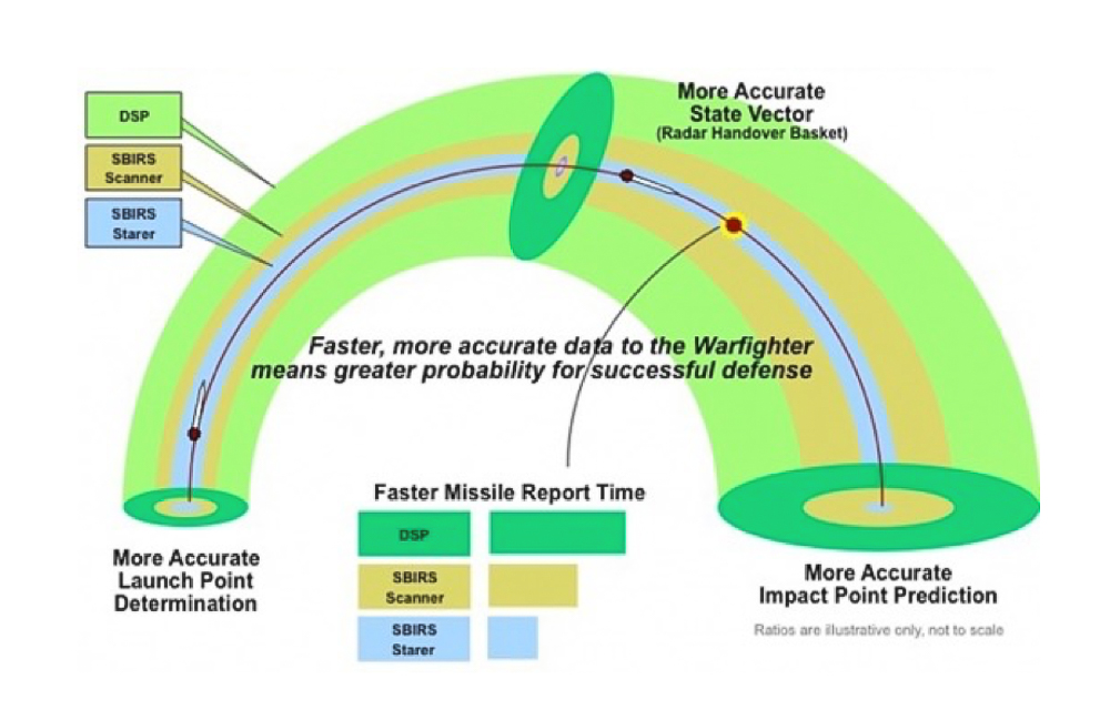
Chart shows SBIRS GEO and HEO sensor capabilities compared with older DSP. Image Credit: USAF/Aviation Week
“Regional systems present in Asia and the Middle East are well within the range of our deployed forces. The SBIRS constellation is tasked with providing timely, reliable accurate missile warning information to protect our nation and to our troops operating abroad.” Bythewood said.
“Regional missile systems present in Asia and the Middle East are well within the range of our deployed forces, he said.
The first SBIRS GEO was launched in May 2011 on an Atlas V, followed by the second in March 2013. They currently cover the globe from the eastern Atlantic, across Europe, through the Middle East, the Korean Peninsula and all the way to the western Pacific.
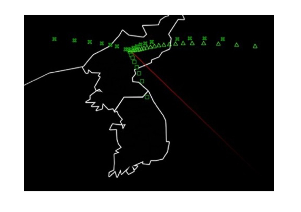
Simulated SBIRS console image of North Korean missile launch. Image Credit: USAF / Northrop Grumman / Aviation Week
The planned GEO-3 location is classified, but the capability of the HEO and GEO satellites we are launching now basically cuts in half the amount of time it takes for the SBIRS network satellite to find and fix a missile launch and feed that into our missile warning network,” Bythewood said.
“What SBIRS brings in capability beyond the Defense Support Program is the ability to find dimmer targets with shorter burn times, representative of the tactical missile threats that we see in Asia and the Middle East today” he said.
The GEO satellites detect and track missile launches globally while the HEO satellites specifically survey northern polar regions and specific IR targets identified by SBIRS or other sensors.
Each GEO satellite is derived from an A2100 bus with a 12 year design life and 9.8 year mean mission duration. It carries a 1,000 lb. Northrup Grumman sensor system with both scanning and staring capability. Along with that it has extremely agile pointing and control capability to provide both strategic and tactical data on missile launch locations and impact points.
Current USAF launch weather forecasts show an 80 percent chance of favorable conditions expected for launch Thursday evening from Florida’s Space Coast, with the primary concern being possible Cumulus Clouds.
Quelle: AS
-
Update: 19.01.2017
.
Quelle: ULA
-
Update: 20.01.2017
.
Atlas V to Launch SBIRS GEO Flight 3 for the U.S. Air Force
Jan. 19, 2017, 8:36 p.m. EST: The launch of a United Launch Alliance Atlas V carrying the SBIRS GEO Flight 3 mission was scrubbed today due to a violation of Eastern Range safety criteria.
The launch is planned for Friday, Jan. 20, from Space Launch Complex-41 at Cape Canaveral Air Force Station. The launch window is 7:42-8:22 p.m. EST. Atlas V SBIRS GEO Flight 3 Mission Overview
Rocket/Payload: An Atlas V 401 will launch the Space-Based Infrared System (SBIRS) GEO Flight 3 mission for the U.S. Air Force.
Date/Site/Launch Time: Friday, Jan. 20, 2017, from Space Launch Complex (SLC)-41 at Cape Canaveral Air Force Station, Florida. The 40-minute launch window opens at 7:42 p.m. EST.
Live Broadcast: Tune in to ULA’s live launch day broadcast beginning at 7:22 p.m. EST.
Mission Description: SBIRS, considered one of the nation's highest priority space programs, is designed to provide global, persistent, infrared surveillance capabilities to meet 21st century demands in four national security mission areas including: missile warning, missile defense, technical intelligence and battlespace awareness.
Launch Notes: SBIRS GEO Flight 3 will be ULA’s first launch of 2017 and the 69th Atlas V mission overall. This mission marks the 34th Atlas V mission in the 401 configuration; the two previous SBIRS GEO missions also launched on the Atlas V 401 rocket.
Quelle: ULA
-
Update: 21.01.2017
.
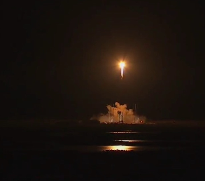
Atlas V makes successful launch from Cape Canaveral
Update:The Atlas V rocket successfully lifted off from Cape Canaveral Air Force Station at 7:42 p.m. A rescheduled rocket launch in Florida tonight has a 70 percent chance of favorable weather, according to the U.S. Air Force’s weather squadron. United Launch Alliance plans to send a satellite...
Quelle: Orlando Sentinel
---
United Launch Alliance Successfully Launches SBIRS GEO Flight 3 Satellite to Orbit for U.S. Air Force
Cape Canaveral Air Force Station, Fla., (Jan. 20, 2017) – A United Launch Alliance (ULA) Atlas V rocket carrying the Space Based Infrared System (SBIRS) GEO Flight 3 satellite lifted off from Space Launch Complex-41 Jan. 20 at 7:42 p.m. ET. SBIRS GEO Flight 3 is considered one of the nation’s highest priority space programs.
“ULA is proud to deliver this critical satellite which will improve surveillance capabilities for our national decision makers,” said Laura Maginnis, ULA vice president of Government Satellite Launch. “I can’t think of a better way to kick off the new year.”
This mission was launched aboard an Atlas V Evolved Expendable Launch Vehicle (EELV) 401 configuration vehicle, which includes a 4-meter diameter large payload fairing (LPF). The Atlas V booster propulsion for this mission was powered by the RD AMROSS RD-180 engine, and the Centaur upper stage was powered by the Aerojet Rocketdyne RL10C engine.
“The Atlas V 401 configuration has become the workhorse of the Atlas V fleet, delivering half of all Atlas V missions to date” said Maginnis. “ULA understands that even with the most reliable launch vehicles, our sustained mission success is only made possible with seamless integration between our customer and our world class ULA team.”
The Space Based Infrared System is designed to provide global, persistent, infrared surveillance capabilities to meet 21st century demands in four national security mission areas: missile warning, missile defense, technical intelligence and battlespace awareness.
This is ULA’s first launch of 11 planned launches in 2017 and the 116th successful launch since the company was formed in December 2006.
ULA's next East Coast launch is the Delta IV WGS-9 satellite for the U.S. Air Force. The launch is scheduled for March 8 from Space Launch Complex-37 at Cape Canaveral Air Force Station, Fla.
With more than a century of combined heritage, United Launch Alliance is the nation’s most experienced and reliable launch service provider. ULA has successfully delivered more than 115 satellites to orbit that aid meteorologists in tracking severe weather, unlock the mysteries of our solar system provide critical capabilities for troops in the field, and enable personal device-based GPS navigation and unlock the mysteries of our solar system.