
17.08.2025
Giant Radar Antenna Reflector on NASA-ISRO Satellite in Full ‘Bloom’

The NISAR satellite uses a radar antenna reflector that’s 39 feet (12 meters) in diameter to gather information about Earth’s changing surface. The mission scans nearly all the planet’s land and ice surfaces twice every 12 days.
Credit: NASA/JPL-Caltech
Seventeen days after NISAR’s launch from southeastern India, an essential piece of science hardware has unfurled in orbit.
Spanning 39 feet (12 meters), the drum-shaped antenna reflector on the NISAR (NASA-ISRO Synthetic Aperture Radar) satellite mission from NASA and the Indian Space Research Organisation (ISRO) successfully unfurled in low Earth orbit. The reflector had been stowed, umbrella-like, until the 30-foot (9-meter) boom that supports it could be deployed and locked in place.
Launched by ISRO on July 30 from the Satish Dhawan Space Centre on India’s southeastern coast, NISAR will track the motion of ice sheets and glaciers, the deformation of land due to earthquakes, volcanoes, and landslides, and changes in forest and wetland ecosystems down to fractions of an inch. It also will aid decision-makers in fields as diverse as disaster response, infrastructure monitoring, and agriculture.
“The successful deployment of NISAR’s reflector marks a significant milestone in the capabilities of the satellite,” said Karen St. Germain, director, Earth Science Division at NASA Headquarters in Washington. “From innovative technology to research and modeling to delivering science to help inform decisions, the data NISAR is poised to gather will have a major impact on how global communities and stakeholders improve infrastructure, prepare for and recover from natural disasters, and maintain food security.”
The mission carries the most sophisticated radar systems ever launched as part of a NASA mission. In a first, the satellite combines two synthetic aperture radar (SAR) systems: an L-band system that can see through clouds and forest canopy, and an S-band system that can see through clouds as well but is more sensitive to light vegetation and moisture in snow. The reflector plays a key role for both systems, which is why the successful deployment of the hardware is such a significant milestone.
“This is the largest antenna reflector ever deployed for a NASA mission, and we were of course eager to see the deployment go well. It’s a critical part of the NISAR Earth science mission and has taken years to design, develop, and test to be ready for this big day,” said Phil Barela, NISAR project manager at NASA’s Jet Propulsion Laboratory in Southern California, which managed the U.S. portion of the mission and provided one of the two radar systems aboard NISAR. “Now that we’ve launched, we are focusing on fine-tuning it to begin delivering transformative science by late fall of this year.”
How Bloom Works
Weighing about 142 pounds (64 kilograms), the reflector features a cylindrical frame made of 123 composite struts and a gold-plated wire mesh. On Aug. 9, the satellite’s boom, which had been tucked close to its main body, started unfolding one joint at a time until it was fully extended about four days later. The reflector assembly is mounted at the end of the boom.
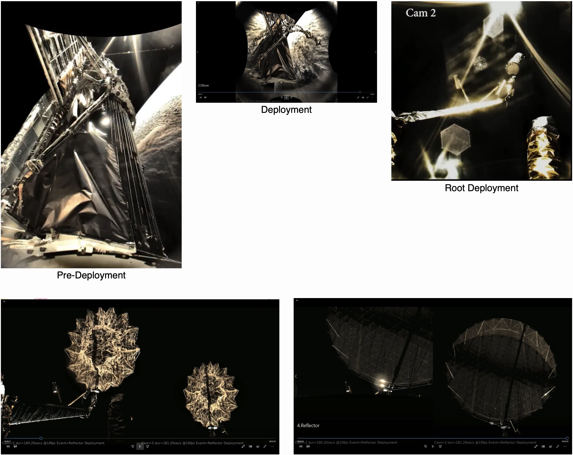
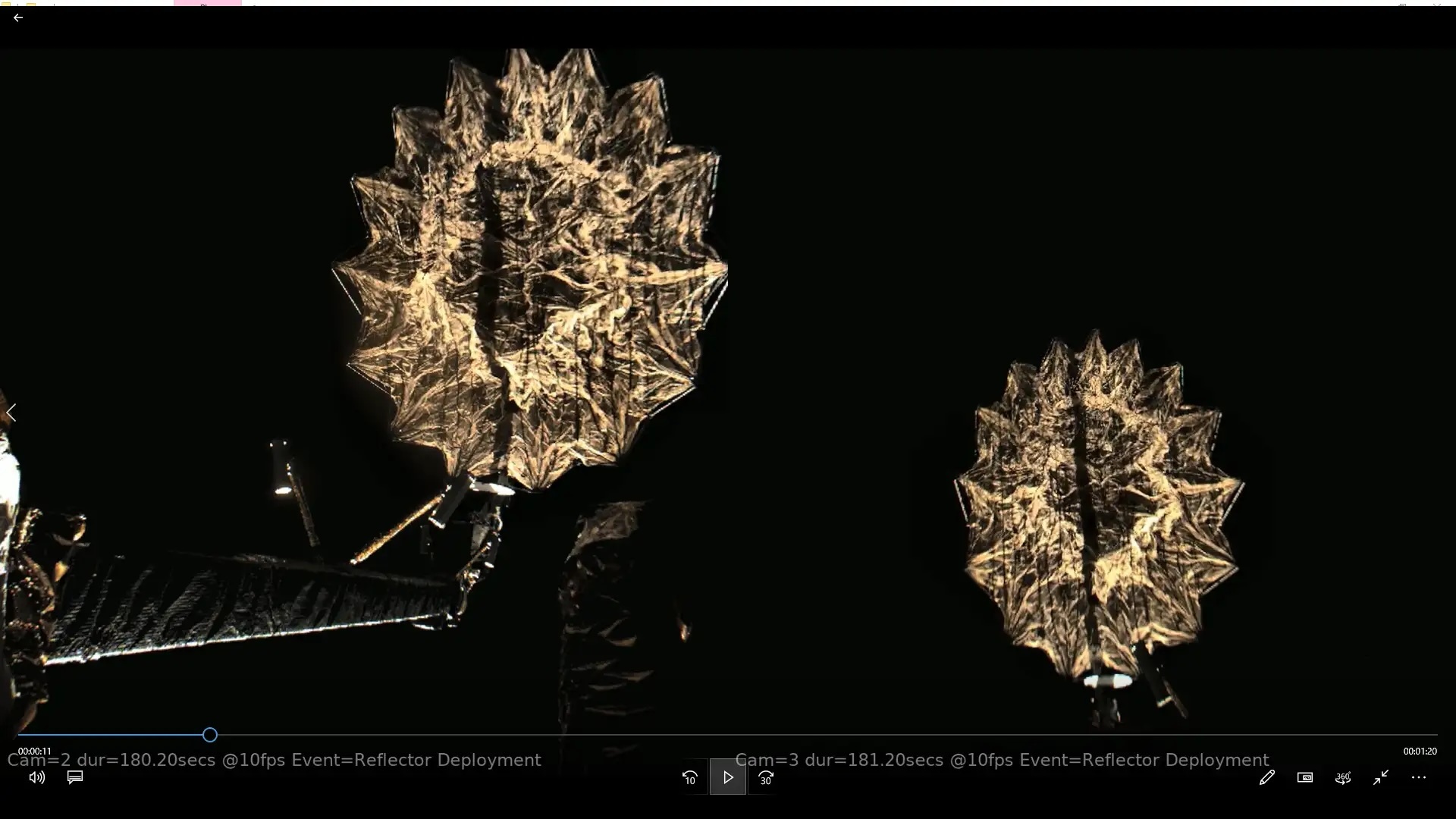
Then, on Aug. 15, small explosive bolts that held the reflector assembly in place were fired, enabling the antenna to begin a process called the “bloom” — its unfurling by the release of tension stored in its flexible frame while stowed like an umbrella. Subsequent activation of motors and cables then pulled the antenna into its final, locked position.

NISAR team members at JPL, along with colleagues at ISRO facilities in India, deployed the satellite’s radar antenna reflector. Depicted on the screen at right, the reflector unfurled from 2 feet (0.6 meters) across in its stowed configuration to its full size, 39 feet (12 meters), in 37 minutes.
Credit: NASA/JPL-Caltech
To image Earth’s surface down to pixels about 30 feet (10 meters) across, the reflector was designed with a diameter about as wide as a school bus is long. Using SAR processing, NISAR’s reflector simulates a traditional radar antenna that for the mission’s L-band instrument would have to be 12 miles (19 kilometers) long to achieve the same resolution.
“Synthetic aperture radar, in principle, works like the lens of a camera, which focuses light to make a sharp image. The size of the lens, called the aperture, determines the sharpness of the image,” said Paul Rosen, NISAR’s project scientist at JPL. “Without SAR, spaceborne radars could generate data, but the resolution would be too rough to be useful. With SAR, NISAR will be able to generate high-resolution imagery. Using special interferometric techniquesthat compare images over time, NISAR enables researchers and data users to create 3D movies of changes happening on Earth’s surface.”
The NISAR satellite is the culmination of decades of space-based radar development at JPL. Starting in the in the 1970s, JPL managed the first Earth-observing SAR satellite, Seasat, which launched in 1978, as well as Magellan, which used SAR to map the cloud-shrouded surface of Venus in the 1990s.
More About NISAR
The NISAR mission is a partnership between NASA and ISRO spanning years of technical and programmatic collaboration. The successful launch and deployment of NISAR builds upon a strong heritage of cooperation between the United States and India in space. The data produced by NISAR’s two radar systems, one provided by NASA and one by ISRO, will be a testament to what can be achieved when countries unite around a shared vision of innovation and discovery.
The ISRO Space Applications Centre provided the mission’s S-band SAR. The U R Rao Satellite Centre provided the spacecraft bus. Launch services were through Satish Dhawan Space Centre. After launch, key operations, including boom and radar antenna reflector deployment, are being executed and monitored by the ISRO Telemetry, Tracking and Command Network’s global system of ground stations.
Managed by Caltech in Pasadena, JPL leads the U.S. component of the project. In addition to the L-band SAR, reflector, and boom, JPL also provided the high-rate communication subsystem for science data, a solid-state data recorder, and payload data subsystem. NASA’s Goddard Space Flight Center in Greenbelt, Maryland, manages the Near Space Network, which receives NISAR’s L-band data.
Quelle: NASA
----
Update: 30.08.2025
.
NASA-ISRO Mission Aces Checkouts, on Track to Start Delivering Science
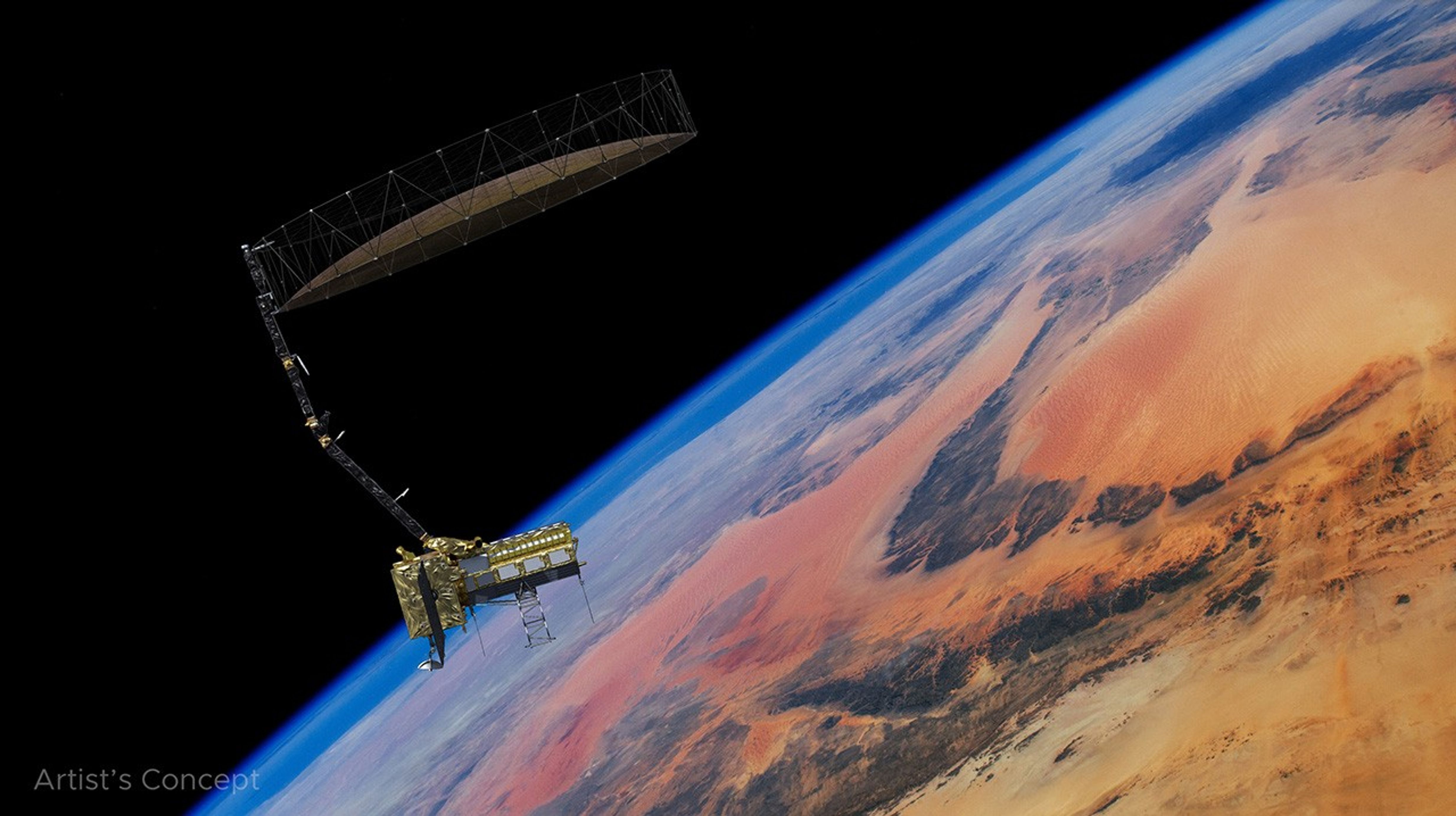
After launching July 30, the NISAR (NASA-ISRO Synthetic Aperture Radar) Earth-observing radar satellite mission, a joint effort between NASA and the Indian Space Research Organisation (ISRO), is on schedule to start science operations this fall.
Following the deployment of its 39-foot (12-meter) radar antenna reflector on Aug. 15, engineers powered on the satellite’s L-band and S-band synthetic aperture radar (SAR) systems, which, together, will track movement of Earth’s ice and land surfaces in unprecedented detail.
In addition, the spacecraft, including the radar payload, has passed all of the preliminary checks performed by NASA and ISRO mission teams to ensure they are operating normally. The mission began raising the satellite to its operational orbit, 464 miles (747 kilometers, mean altitude), on Aug. 26.
The mission team anticipates having science-quality radar images in the coming weeks. Full science operations have been scheduled to begin about 90 days after launch.
The NISAR mission is the first to carry two SAR systems. The L-band radar transmits and receives signals at a 10-inch (24-centimeter) wavelength, enabling it to penetrate forest canopies and measure soil moisture, forest biomass, and the motion of land and ice surfaces. The S-band radar, which uses a 4-inch (10-centimeter) wavelength, is more sensitive to small vegetation and observing certain types of agriculture, grassland ecosystems, and moisture in snow. Both systems can collect data through clouds and precipitation, day and night.
The satellite will monitor most of Earth’s land and ice surfaces twice every 12 days, tracking changes in the planet’s forests, frozen surfaces, major infrastructure, and crust down to fractions of an inch. The lattermost is a key measurement in understanding how the land surface moves before, during, and after earthquakes, volcanic eruptions, and landslides.
More About NISAR
The NISAR mission is a partnership between NASA and ISRO spanning years of technical and programmatic collaboration. The successful launch and deployment of NISAR builds upon a strong heritage of cooperation between the United States and India in space. The data produced by NISAR’s two radar systems, one provided by NASA and one by ISRO, will be a testament to what can be achieved when countries unite around a shared vision of innovation and discovery.
The ISRO Space Applications Centre provided the mission’s S-band SAR. The U R Rao Satellite Centre provided the spacecraft bus. Launch services were through Satish Dhawan Space Centre. After launch, key operations, including boom and radar antenna reflector deployment, are being executed and monitored by the ISRO Telemetry, Tracking and Command Network’s global system of ground stations.
Managed by Caltech in Pasadena, NASA’s Jet Propulsion Laboratory in Southern California leads the U.S. component of the project. In addition to the L-band SAR, reflector, and boom, JPL also provided the high-rate communication subsystem for science data, a solid-state data recorder, and payload data subsystem. NASA’s Goddard Space Flight Center in Greenbelt, Maryland, manages the Near Space Network, which receives NISAR’s L-band data.
Quelle: NASA
----
Update: 30.11.2025
.
RADAR Antenna Deployment
After the successful launch of NASA ISRO Synthetic Aperture Radar (NISAR) satellite onboard GSLV – F16 on July 30, 2025, the 12m diameter Antenna reflector has been successfully deployed. The 12-meter diameter antenna reflector plays a key role for both ISRO’s S-Band and NASA’s L-Band Synthetic Aperture Radar (SAR) Payload. The antenna was launched in a stowed condition on a 9m long boom, which was tucked closed to the satellite. The antenna and the 9m boom was developed by NASA.
The unfolding of the joints of the boom commenced on August 09, 2025 and was carried out over a period of five (05) days (Wrist, Shoulder, Elbow and Root deployments). The reflector assembly mounted on the end of the boom was deployed successfully on August 15, 2025 and the performance of the antenna systems are satisfactory.
The entire operations were carried out from ISRO Telemetry Tracking and Command Network (ISTRAC), ISRO with the support of JPL/NASA.
12m dia antenna reflector deployment image
ISRO
Completion of Commissioning Phase:
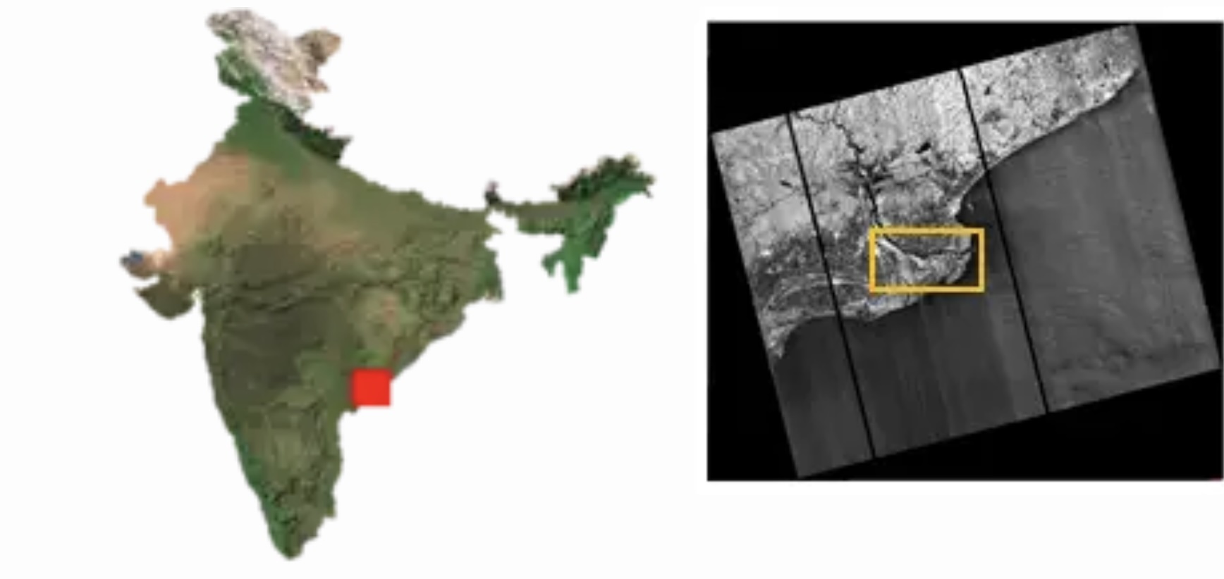
Since the first acquisition on 19th August, 2025, NISAR S-Band SAR is regularly imaging over Indian Landmass and Global Calibration-Validation sites in various payload operating configurations. Reference targets such as Corner reflectors were deployed around Ahmedabad, Gujarat and a few more locations in India for calibration of the images. Data acquired over Amazon rainforests were also used for calibration of spacecraft pointing and images. Based on this, payload data acquisition parameters were fine-tuned resulting in high quality images. Initial analysis by scientists and engineers revealed the potential of S-Band SAR data for various targeted science and application areas like agriculture, forestry, geo-sciences, hydrology, Polar/Himalayan ice/snow and oceanic studies. The first image of S-band SAR acquired on 19th Aug 2025 captures the fertile Godavari River Delta in Andhra Pradesh, India. Various vegetation classes like mangroves, agriculture, arecanut plantations, acquaculture fields, etc are clearly seen in the image. The image highlights NISAR’s S-Band SAR ability to map river deltas and agricultural landscapes with precision.
In the 100th day of NISAR in-orbit, the S-SAR images are released to the public by Chairman, ISRO/ Secretary DOS. With this, the commencement of science phase has also been announced.
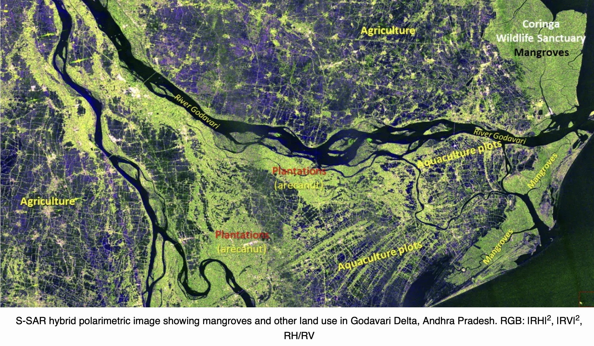
Quelle: ISRO
----
Update: 14.12.2025
.
NASA Satellite Data Could Soon Lead to Safer Bridges Worldwide

Researchers are turning to satellite data to monitor the world’s longest bridges. Due to high costs and logistical challenges, fewer than 1 in 5 bridges extending 492 feet (150 meters) or more have systems installed to track structural changes that might be harbingers of damage or danger. Satellites could more than triple the portion of bridges globally that are actively being monitored for safety and structural health, researchers say.
In a study in Nature Communications, researchers evaluated the feasibility of using a pair of European Space Agency satellites that make up the Sentinel-1 constellation to gather high-resolution radar data from bridges. They found that a data analysis technique known as Multi-Temporal Interferometric Synthetic Aperture Radar (MT-InSAR) can reveal structural displacements as small as a few millimeters. Though tiny, comparable to the thickness of a dime, these small shifts can be evidence of structural weakness.
The researchers hope to soon begin using data from the recently-launched NISAR (NASA-ISRO Synthetic Aperture Radar) satellite, jointly operated by NASA and the Indian Space Research Organisation. NISAR will collect higher resolution data than the Sentinel satellites, which researchers expect will provide more meaningful information for civil engineers keeping an eye on long-span bridges.
On-site inspections and sensors installed on bridges remain crucial for monitoring structural health. But including spaceborne SAR monitoring could expand regular oversight from less than 20% of the 744 long-span bridges worldwide to more than 60%, the researchers say. Satellite data will be particularly useful in remote regions where installing traditional sensors and conducting on-site inspections can be prohibitively expensive.
NISAR will systematically gather imagery of nearly every bridge in the world twice every 12 days. This comprehensive radar time series will make it possible to identify and track subtle changes not only to bridges but also other infrastructure, such as dams, railways, buildings, and levees. NASA’s free and open data policy means that anyone can use NISAR data to evaluate infrastructure.
Quelle: NASA
----
Update: 23.07.2026
.
US-India Satellite Delivers Data, Reveals ‘Hummingbird’ in Antarctica
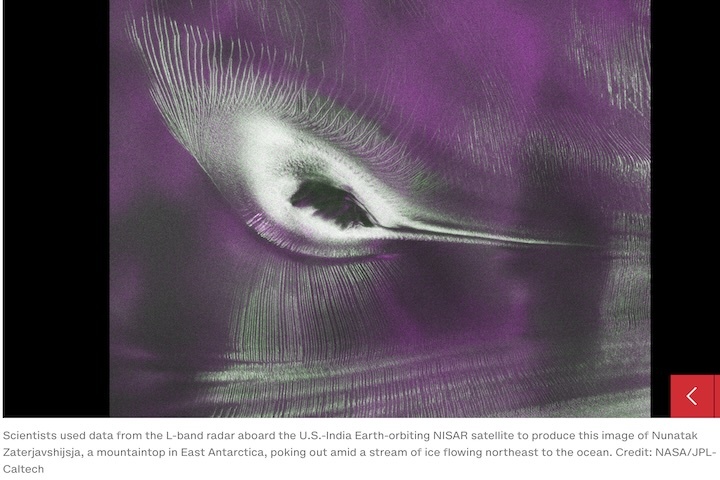
Data from NISAR, one of the most powerful radar systems ever launched, is now available to the world. A vivid image of Antarctic ice showcases what the satellite can do.
As of July 20, the public can access data from the two powerful radar instruments aboard the NISAR (NASA-ISRO Synthetic Aperture Radar) satellite. Teams in the United States and India will release files processed from the satellite’s L-band and S-band radars on an ongoing basis, helping researchers and other users track the movement of Earth’s land and ice masses, monitor changes in ecosystems like forests and wetlands, and respond to natural hazards such as landslides and earthquakes.
The release comes as NASA and ISRO (Indian Space Research Organisation) prepare to celebrate the first anniversary of NISAR’s July 30, 2025, launch from India’s Satish Dhawan Space Centre. Since that time, the mission engineering and science teams have been busy calibrating instrumentation, refining algorithms, and monitoring nearly all the planet’s land- and ice-covered surfaces twice every 12 days. Along the way, the team has captured scenes from around the globe — urban street grids, agricultural fields, landslides, earthquakes, and sinking land in Mexico City.
An early image released Tuesday revealed the fractured, barren surface of an Antarctic landscape in stark detail. In a merging of science and serendipity, it also resembles something else entirely: a hummingbird.
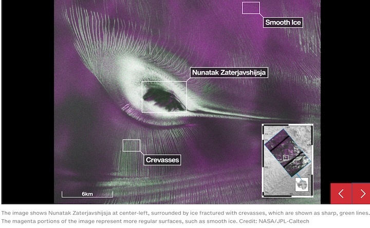
Despite its otherworldly quality, the Antarctic image shows a very real geographical feature called Nunatak Zaterjavshijsja, a mountaintop in East Antarctica, poking out amid a stream of ice flowing northeast to the ocean. As the moving glacier passes the obstruction, the mountain’s topography causes stresses in the ice, heavily fracturing the surrounding surfaces with deep cracks, called crevasses, which show as sharp green lines in the image.
“First, it’s a beautiful image, with rich details of features that provide insights to how the glacier is moving. Then, because radar can often see through snow and deep into the ice, NISAR can observe fundamentally different properties of Antarctic ice than can be seen in optical imagery,” said Seongsu Jeong, the signal analysis engineer who produced the image at NASA’s Jet Propulsion Laboratory in Southern California. “With NISAR we’re seeing what’s hidden beneath the surface.”
Story in magenta, green
Generated with measurements that NISAR’s L-band instrument gathered in August 2025, as U.S. and Indian mission teams tested the satellite’s systems, the “hummingbird” exemplifies one of the young mission’s hallmarks: intricately detailed imagery that is both informative and eye-catching.
The colors show differences in the way polarized microwave signals, which vibrate in different directions, interact with and reflect from the ice. Over Antarctica, NISAR transmits radar waves toward Earth with a horizontal polarization. The orientation of the signals that return — either horizontal, vertical, or both — provide clues about the object or surface that reflected them.
Signals that come back with a horizontal polarization likely bounced off a more regular surface, such as smooth ice. Those signals appear magenta in the image. Signals that return with vertical polarization may have refracted as they partially penetrated the snow and ice or scattered at different angles as they reflected off irregular surfaces, such as the faces of crevasses. Called volume scattering, these observations are displayed in green.
The white represents areas in which magenta and green signals scatter back strongly, a possible indication that there is an equal blend of surface and volume scattering.
The same scene viewed in optical light is almost entirely white with ice and snow. Slight shadows and rippling indicate the presence of the mountaintop, and textures in the surrounding area suggest the ice is not completely smooth.
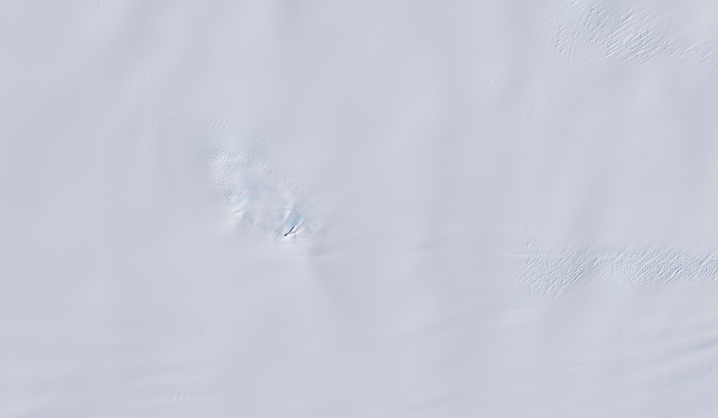
An image from the Landsat 9 satellite shows Nunatak Zaterjavshijsja on Nov. 2, 2025. Because microwaves can penetrate frozen surfaces, signals from NISAR’s L-band radar captured more detail of the structure of the surrounding icescape than is visible in this optical image.
Access to data
The NISAR satellite is the first free-flying space mission to feature two radar instruments: an L-band system and an S-band system. The systems are complementary due to their differing wavelengths. For example, the longer-wave L-band can pass through tree canopies, imaging the ground beneath. Meanwhile, depending on leaf sizes, S-band can collect observations of those canopies.
The Indian science team, based at ISRO’s Space Applications Centre in Ahmedabad, recently started releasing S-band data via the Bhoonidhi portal.
On July 20, the U.S. side of the mission started releasing calibrated products continuously for all L-band measurements collected since June 17. By the end of the year, the team expects to have released all data acquired earlier during science operations. The NISAR project science team previously had two limited releases of L-band data, the first in January of about 25 sample products and a release in February of thousands of pre-calibrated products.
As with the earlier releases, data users will be able to download the latest files at the Alaska Satellite Facility Distributed Active Archive Center in Fairbanks, which hosts and distributes all NASA synthetic aperture radar data.
The NISAR mission’s science data output is vast, on the order of dozens of terabytes a day, due to the satellite’s frequent coverage of nearly all the land and ice surfaces on Earth. It scans from within a few degrees of the South Pole in Antarctica to 77.5 degrees north latitude, above the Arctic Circle.
Quelle: NASA
----
Update: 24.08.2026
.
Indo-US NISAR, most advanced imaging satellite, completes one year in operational orbit
Joint NASA-ISRO mission tracks Earth’s land, ice and ecosystems with unprecedented precision

Giving the impression of a “hummingbird”, a radar image from NISAR shows a mountain top in East Antarctica surrounded by flowing ice and deep crevasses that would otherwise not be visible. Image credit: NASA
The NASA-ISRO Synthetic Aperture Radar (NISAR) satellite, described as the most advanced Earth-imaging spacecraft sent to space, completes one year of operational service this month.
“NASA-ISRO Mission Aces Checkouts, on Track to Start Delivering Science,” NASA posted on its website on August 28, 2025. The spacecraft had deployed its giant 39-foot-diameter radar antenna reflector on August 15, following which engineers powered on and checked its L-band and S-band synthetic aperture radar (SAR) systems, designed to track movement of Earth’s ice and land surfaces in unprecedented detail.
Launched aboard ISRO’s GSLV F16 rocket, NISAR was raised to its final operational orbit at a mean altitude of 747 km above Earth on August 26. It is the first space mission to carry two SAR systems.
The L-band radar transmits and receives signals at a 10-inch wavelength, enabling it to penetrate forest canopies and measure soil moisture, forest biomass and the movement of land and ice surfaces.
The S-band radar, which uses a 4-inch wavelength, is more sensitive to smaller vegetation and is suited to observing certain types of agriculture, grassland ecosystems and moisture in snow. Both systems can collect data through clouds and precipitation, day and night.
The satellite will monitor most of Earth’s land and ice surfaces twice every 12 days, tracking changes in forests, frozen surfaces, major infrastructure and the planet’s crust with sub-inch precision. The latter is crucial for understanding how land surfaces move before, during and after earthquakes, volcanic eruptions and landslides, NASA said.
ISRO’s Space Applications Centre provided the mission’s S-band SAR, while the UR Rao Satellite Centre provided the spacecraft bus — the satellite platform on which the sensors are mounted. After launch, key operations, including the deployment of the boom and radar antenna reflector, have been executed and monitored by ISRO’s Telemetry, Tracking and Command Network through a global network of ground stations.
NASA’s Jet Propulsion Laboratory (JPL) in Southern California was responsible for the L-band SAR, reflector, boom, high-rate communication subsystem for science data, solid-state data recorder and payload data subsystem. NISAR’s L-band data is received by NASA’s Near Space Network at the Goddard Space Flight Center in Maryland.
“NISAR continues to systematically collect precious data to understand the Earth's dynamics to drive advancements across multiple scientific disciplines, including ecosystem, solid earth, cryosphere, hydrology, oceanography, coastal-processes, geoscience and disaster response,” ISRO said in a statement marking one year of operations.
NISAR is the first mission to systematically and globally study the solid Earth, ice masses and ecosystems, areas that are currently sparsely sampled. According to the National Remote Sensing Centre, which processes NISAR products, the addition of the S-band considerably extends measurement sensitivity alongside the L-band while reducing sensitivity to ionospheric and soil-moisture effects.
Quelle: The Tribune
----
Update: 26.09.2026
.
US-India Satellite Captures Time-lapse Video of Volcanic Eruption
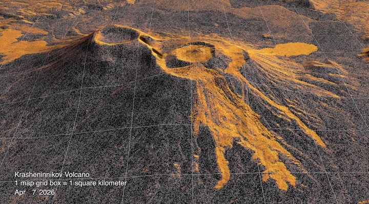
In this animation, frames of NISAR data from December 2025 to August 2026 show the spread of lava from the northern crater of Krasheninnikov, a volcano pair on Russia’s Kamchatka Peninsula. In the image, the lava field appears brighter in the foreground than the surrounding surfaces.
Credit: NASA’s Scientific Visualization Studio
Returning to the same spot in orbit numerous times over several months, NISAR documented the ongoing lava flow from a volcano on the Kamchatka Peninsula.
Like tendrils on a vine, lava spreads out from the northern crater of Krasheninnikov, a volcano pair on the Pacific coast of Russia’s Kamchatka Peninsula. On July 30, 2025, an 8.8-magnitude earthquake had struck in the nearby ocean, apparently jolting one of the two volcanoes awake. A few days later, for the first time in nearly five centuries, Krasheninnikov started erupting. Since that day, the northern volcano has been spilling a steady, eastward-flowing field of molten rock and debris, and the NASA-ISRO Synthetic Aperture Radar (NISAR) mission has been tracking the changes in the landscape.
From its vantage point 464 miles (747 kilometers) above the surface, NISARcaptured an image of Krasheninnikov on Dec. 25, 2025, just as the Earth-observing satellite was finishing post-launch checks and becoming operational. Twice every 12 days since — once as the satellite passed south to north, and again as it passed north to south — NISAR has returned to the same spot in orbit and taken detailed radar snapshots.
Researchers put 17 of the frames captured through mid-August into sequence, forming a time-lapse video that shows lava filling a smaller, inner caldera, then overflowing into a wider crater before widening into a fan. The animation highlights how NISAR’s observations can monitor the development of natural hazards, both for science and potentially for emergency response.
Though remote, many of Kamchatka’s dozens of volcanoes are closely monitored with ground instruments because they erupt frequently. Not so with Krasheninnikov, which has been quiet since about the year 1550. That NISAR’s L-band radar observed it at all speaks to the satellite’s near-global coverage of the planet’s land surface at resolutions in the dozens of feet; that it captured the erupting volcano over time shows the precision and reliability of its measurements.
“The consistency is crucial. Twice every 12 days, acquiring in this high-resolution mode and in two observation directions, this shows the promise of NISAR to closely monitor natural hazards,” said Matthew Pritchard, a member of the NISAR science team and geophysicist at Cornell University who analyzed the data used to create the animation.
Images from microwaves
The detail in a single NISAR image results from the use of synthetic aperture radar, or SAR, a specialized processing technique pioneered by NASA’s Jet Propulsion Laboratory in Southern California for Earth observation from space. As the satellite orbits, the radar sends thousands of microwave pulses per second to Earth and receives the return signals, each of which is effectively a snapshot in time that contains information about the properties and characteristics of the surface below.
The SAR processing combines the many images of the same area, sharpening the view just as a lens brings a blurry object into focus. Each pixel in the individual frames of the Krasheninnikov time-lapse represents about a 30-foot-by-30-foot (10-meter-by-10-meter) square on the surface — about half the size of a tennis court.
Lava shows up lighter in the images due to the way that microwaves reflect more brightly compared with the surrounding surface, which, depending on the time of year, is either snow or bare ground. In addition to the lava field growing to the east, the video shows another flow to the northwest, one that likely formed before NISAR captured the first NISAR image.
When Pritchard was doing his doctoral research on Kamchatka volcanoes more than 20 years ago, analysis-ready radar data was difficult to come by, both because satellites didn’t revisit as often and the resolution of the images was relatively low.
Now in addition to getting frequent and comprehensive coverage of virtually all the planet’s roughly 1,300 active, above-sea-level volcanoes, the images are sharp down to the several-meter scale and are easily accessible via the cloud.
“We’re seeing volcanoes around the world that we’ve never really had eyes on like this before,” said Pritchard.
The NISAR satellite is the first free-flying space mission to feature two radar instruments: an L-band system and an S-band system. The systems are complementary due to their differing wavelengths. For example, the longer-wave L-band can pass through tree canopies, imaging the ground beneath. Meanwhile, depending on leaf sizes, S-band can collect observations of those canopies.
The data products from the NISAR mission’s L-band radar are available at the Alaska Satellite Facility Distributed Active Archive Center in Fairbanks, which hosts and distributes all NASA synthetic aperture radar data.
Quelle: NASA