
.9.12.2013
A Chinese Long March 4B launched the CBERS-3 satellite on Monday, marking the fourth cooperative mission between China and Brazil. The launch took place at 03:26 UTC from the LC9 Launch Complext at the Taiyuan Satellite Launch Center. CBERS-3 will operate on a sun-synchronous orbit at an altitude of 778 kilometers.
CBERS (China-Brazil Earth Resources Satellite) is a cooperative program between China and Brazil, following an initial agreement in 2002.
The CBERS-3 spacecraft – with a mass of 2,100 kg - consists of a hexahedron shaped structure divided in service and payload modules.
In its orbital configuration, the Z axis is pointed towards the Earth’s surface utilizing “3-axis stabilization”, with cameras and antennas mounted on the +Z side panel.
The spacecraft’s solar panel is mounted on the -Y side panel and rotates around the Y axis, while the antennas, thrusters and attitude sensors – such as the sun sensors and infrared Earth sensors – are mounted on other panels.
The Attitude and Orbit Control Subsystem (AOCS) includes star sensors, sun sensors, infrared Earth sensors, gyros, GPS receiver, a control computer, momentum wheels and a hydrazine propulsion system.
Thermal control is achieved by passive means, using thermal coating and multi-layer insulation blankets. The EPS (Electrical Power Subsystem) uses triple-junction GaAs solar panels, a shunt regulator, battery charge control, a battery discharge regulator, DC/DC converters and NiCd (Nickel Cadmium) batteries.
The EPS can provide 2.30 kW to the spacecraft.
The On-Board Data Handling (OBDH) subsystem consists of a main computer and seven remote terminal units to provide onboard data handling and the spacecraft monitoring and control functions.
The S-band antenna provides two-way communications with the ground and offers near omni-directional coverage. The payload image data are downlinked in X-band by two TWTA transmitters.
CBERS-3 carries four cameras – MUXCam, PanMUX, IRS and WFI - in the payload module, with improved geometrical and radiometric performance.
MUXCam is an INPE instrument designed and developed in Brazil, with an objective to provide imagery for cartographic applications.
MUXCam is a multispectral camera with four spectral bands covering the wavelength range from blue to near infrared (from 450 nm to 890 nm) with a ground resolution of 20 m and a ground swath width of 120 km.
The MUXCam instrument consists of three elements of hardware known as RBNA, RBNB and RBNC.
The RBNA provides image acquisition and is composed of an optical system (entrance mirror and lens assembly), optical housing and the focal plane assembly.
The RBNB consists of the electronics responsible for the thermal control, focus adjustment and the internal calibration system control. The RBNC subsystem generates the reading clocks, processing the analog outputs to digital signal, and data encoding into a serial data stream.
The CCD detector is a 4-line array, each line has 6000 pixels of size: 13 µm x 13 µm. Spectral thin films, deposited over a window that covers the photosensitive elements of the CCD, are responsible for the separation of the four spectral bands.
Provided by China, the PanMUX (Panchromatic and Multispectral Camera) is a CCD pushbroom camera that provides panchromatic images and sports focal plane adjustment and on-orbit calibration capabilities.
The IRS (Infrared System) – or IRMSS-2 (Infrared Multispectral Scanner-2) – is an imager with four spectral bands. It was developed via the heritage of China’s Infrared Multispectral Scanner, as used on previous missions.
The WFI (Wide-Field Imager) – also referred to as WFI-2 – is an advanced version of an instrument flown on CBERS-1, and CBERS-2, featuring four spectral bands with a ground resolution of 64 m at nadir and a ground swath of 866 km.
The WFI instrument on CBERS-3 also provides an improved spatial resolution in comparison with the previous WFI sensors on board of the CBERS-1 and CBERS-2 satellites.
This camera will be used for remote sensing of the Earth and is aimed to work at an altitude of 778 km. The optical system is designed for four spectral bands covering the range of wavelengths from blue to near infrared.
Beside the cameras, CBERS 3 also includes the DCS (Data Collection System) and the SEM (Space Environment Monitor). The DCS is provided by INPE and the SEM is provided by CAST (Chinese Academy of Space Technology).
This was the 200th orbital launch by the Chinese, and their 188th success. It also marked 14th orbital launch by China in 2013 – with five of the launches taking place from Taiyuan.
The Launch Vehicle:
The feasibility study of the CZ-4 Chang Zheng-4 began in 1982 based on the FB-1 Feng Bao-1 launch vehicle. Engineering development was initiated in the following year. Initially, the Chang Zheng-4 served as a back-up launch vehicle for Chang Zheng-3 to launch China’s communications satellites.
After the successful launch of China’s first DFH-2 communications satellites by Chang Zheng-3, the main mission of the Chang Zheng-4 was shifted to launch sun-synchronous orbit meteorological satellites. On other hand, the Chang Zheng-4B launch vehicle was first introduced in May 1999 and also developed by the Shanghai Academy of Space Flight Technology (SAST), based on the Chang Zheng-4.
The rocket is capable of launching a 2,800 kg satellite into low Earth orbit, developing 2,971 kN at launch. With a mass of 248,470 kg, the CZ-4B is 45.58 meters long and has a diameter of 3.35 meters.
SAST began to develop the Chang Zheng-4B in February 1989. Originally, it was scheduled to be commissioned in 1997, but the first launch didn’t take place until late 1999. The modifications introduced on the Chang Zheng-4B included a larger satellite fairing and the replacement of the original mechanical-electrical control on the Chang Zheng-4 with an electronic control.
Other modifications were an improved telemetry, tracking, control, and self-destruction systems with smaller size and lighter weight; a revised nuzzle design in the second stage for better high-altitude performance; a propellant management system for the second stage to reduce the spare propellant amount, thus increasing the vehicle’s payload capability and a propellant jettison system on the third-stage.
The first stage has a 24.65 meter length with a 3.35 meter diameter, consuming 183,340 kg of N2O4/UDMH (gross mass of first stage is 193.330 kg). The vehicle is equipped with a YF-21B engine capable of a ground thrust of 2,971 kN and a ground specific impulse of 2,550 Ns/kg. The second stage has a 10.40 meter length with a 3.35 meter diameter and 38,326 kg, consuming 35,374 kg of N2O4/UDMH.
The vehicle is equipped with a YF-22B main engine capable of a vacuum thrust of 742 kN and four YF-23B vernier engines with a vacuum thrust of 47.1 kN (specific impulses of 2,922 Ns/kg and 2,834 Ns/kg, respectively).
The third stage has a 4.93 meter length with a 2.9 meter diameter, consuming 12,814 kg of N2O4/UDMH. Having a gross mass of 14,560 kg, it is equipped with a YF-40 engine capable of a vacuum thrust of 100.8 kN and a specific impulse in vacuum of 2,971 Ns/kg.
The Launch Center:
Situated in the Kelan County in the northwest part of the Shanxi Province, the Taiyuan Satellite Launch Center (TSLC) is also known by the Wuzhai designation. It is used mainly for polar launches (meteorological, Earth resources and scientific satellites).
The launch center has two single-pad launch complexes, a technical area for rocket and spacecraft preparations, a communications centre, a mission command and control centre, and a space tracking centre.
The stages of the rocket are transported to the launch centre by railway, and offloaded at a transit station south of the launch complex. They are then transported by road to the technical area for checkout procedures.
The launch vehicles are assembled on the launch pad by using a crane at the top of the umbilical tower to hoist each stage of the vehicle in place. Satellites are airlifted to the Taiyuan Wusu Airport about 300km away, and then transported to the centre by road.
The TT&C Centre, also known as Lüliang Command Post, is headquartered in the city of Taiyuan, It has four subordinate radar tracking stations in Yangqu (Shanxi), Lishi (Shanxi), Yulin (Shaanxi), and Hancheng (Shaanxi).
Quelle: NSC
.
Update: 10.12.2013
.
Chinese-Brazilian Satellite Destroyed after Long March Rocket Fails
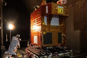
The CBERS-3 satellite at the China Space Center. Credit: Photo courtesy of INPE (Instituto Nacional de Pesquisas Espaciais)
PARIS — The Chinese-Brazilian CBERS-3 Earth observation satellite was destroyed Dec. 9 following a failure of a Chinese Long March 4B rocket launched from China’s Taiyuan Satellite Launch Center, the Brazilian Space Agency (AEB) announced.
AEB said the CBERS-3 satellite, built mainly in Brazil, appeared to have been in good health as the rocket launched, but that it likely fell to Earth when the rocket failed.
“Preliminary indications are that the satellite has returned” to Earth, AEB said. “There was a malfunction of the launch vehicle.”
AEB said that China and Brazil nonetheless are determined to pursue the CBERS program, which began in 1999 with the launch of CBERS-1. CBERS-2 was launched in 2003, and CBERS-2B followed in 2007. Work on a CBERS-4 satellite would start immediately, AEB said.
The Long March 4B rocket debuted in 2009. It has launched 19 times since then, with the Dec. 9 launch its 20th.
Quelle: SpaceNews
.
China's remote-sensing satellite fails to enter orbit
China's high-resolution remote-sensing satellite Ziyuan I-03 failed to enter orbit after its launch earlier Monday, military sources said.
"The rocket malfunctioned during the flight, and the satellite failed to enter orbit," said the sources, adding that Chinese and Brazilian experts are analyzing the cause of the failure.
The satellite, jointly developed by China and Brazil, was launched at 11:26 a.m. aboard a Long March 4B rocket from Taiyuan Satellite Launch Center in north China's Shanxi Province.
Quelle: ChinaNews
5576 Views