Scientists recently recorded the lowest temperatures on Earth at a desolate and remote ice plateau in East Antarctica, trumping a record set in 1983 and uncovering a new puzzle about the ice-covered continent.
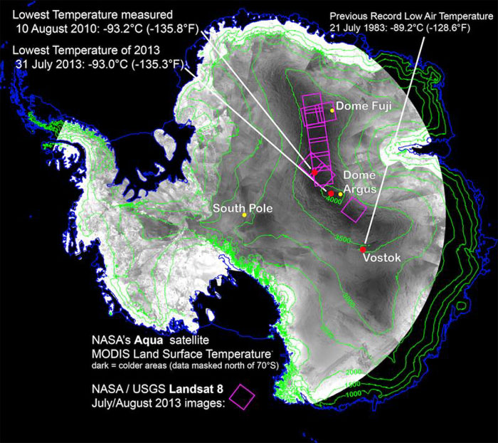
This image shows the location of record low temperature measurements for Antarctica. The red dots show where the record satellite-measured surface temperatures and the earlier record low air temperature occurred. Shades of gray are a compilation of the lowest MODIS-sensor land surface temperature readings made by NASA's Aqua satellite during 2003-2013, with darker grays representing the coldest areas. Landsat 8 thermal images acquired in July and August of 2013 provided more detail on the coldest areas (purple squares). Elevation of the Antarctic surface is shown in green lines, and a blue lines provide an outline of the Antarctic continent, its islands, and the edge of its floating ice sheet. (Credit: Ted Scambos, National Snow and Ice Data Center)
.
Ted Scambos, lead scientist at the National Snow and Ice Data Center (NSIDC), and his team found temperatures from −92 to −94 degrees Celsius (−134 to −137 degrees Fahrenheit) in a 1,000-kilometer long swath on the highest section of the East Antarctic ice divide.
The measurements were made between 2003 and 2013 by the Moderate Resolution Imaging Spectroradiometer (MODIS) sensor on board NASA's Aqua satellite and during the 2013 Southern Hemisphere winter by Landsat 8, a new satellite launched early this year by NASA and the U.S. Geological Survey.
"I've never been in conditions that cold and I hope I never am," Scambos said. "I am told that every breath is painful and you have to be extremely careful not to freeze part of your throat or lungs when inhaling."
The record temperatures are several degrees colder than the previous record of −89.2 degrees Celsius (−128.6 degrees Fahrenheit) measured on July 21, 1983 at the Vostok Research Station in East Antarctica. They are far colder than the lowest recorded temperature in the United States, measured at −62 degrees Celsius (−79.6 degrees Fahrenheit) in Alaska, in northern Asia at -68 degrees Celsius (−90.4 degrees Fahrenheit), or even at the summit of the Greenland Ice Sheet at -75 degrees Celsius (−103 degrees Fahrenheit).
Scambos said the record temperatures were found in several 5 by 10 kilometer (3 by 6 mile) pockets where the topography forms small hollows of a few meters deep (2 to 4 meters, or 6 to 13 feet). These hollows are present just off the ice ridge that runs between Dome Argus and Dome Fuji -- the ice dome summits of the East Antarctic Ice Sheet. Antarctic bases sit on each of the sites and are generally not occupied during Antarctic winters.
Under clear winter skies in these areas, cold air forms near the snow surface. Because the cold air is denser than the air above it, it begins to move downhill. The air collects in the nearby hollows and chills still further, if conditions are favorable.
"The record-breaking conditions seem to happen when a wind pattern or an atmospheric pressure gradient tries to move the air back uphill, pushing against the air that was sliding down," Scambos said. "This allows the air in the low hollows to remain there longer and cool even further under the clear, extremely dry sky conditions," Scambos said. "When the cold air lingers in these pockets it reaches ultra-low temperatures."
"Any gardener knows that clear skies and dry air in spring or winter lead to the coldest temperatures at night," Scambos said. "The thing is, here in the United States and most of Canada, we don't get a night that lasts three or four or six months long for things to really chill down under extended clear sky conditions."
Centuries-old ice cracks
Scambos and his team spotted the record low temperatures while working on a related study on unusual cracks on East Antarctica's ice surface that he suspects are several hundred years old.
"The cracks are probably thermal cracks -- the temperature gets so low in winter that the upper layer of the snow actually shrinks to the point that the surface cracks in order to accommodate the cold and the reduction in volume," Scambos said. "That led us to wonder what the temperature range was. So, we started hunting for the coldest places using data from three satellite sensors."
More than 30 years of data from the Advanced Very High Resolution Radiometer (AVHRR) on the NOAA Polar Orbiting Environmental Satellite (POES) series gave Scambos a good perspective on what the pattern of low temperatures looked like across Antarctica.
"Landsat 8 is still a new sensor, but preliminary work shows its ability to map the cold pockets in detail," Scambos said. "It's showing how even small hummocks stick up through the cold air."
Scambos suspected they would find one area that got extremely cold. Instead they found a large strip at high altitude where several spots regularly reach record low temperatures. Furthermore, dozens of these extremely cold areas reached about the same minimum temperatures of −92 to −94 degrees Celsius (−134 to −137 degrees Fahrenheit) on most years.
"This is like saying that on the coldest day of the year a whole strip of land from International Falls, Minnesota to Duluth, Minnesota to Great Falls, Montana reached the exact same temperature, and more than once," Scambos said. "And that's a little odd."
A physical limit
The scientists suspect that a layer in the atmosphere above the ice plateau reaches a certain minimum temperature and is preventing the ice plateau's surface from getting any colder.
"There seems to be a physical limit to how cold it can get in this high plateau area and how much heat can escape," Scambos said. Although an extremely cold place, Antarctica's surface radiates heat or energy out into space, especially when the atmosphere is dry and free of clouds.
"The levels of carbon dioxide, nitrogen oxide, traces of water vapor and other gases in the air may impose a more or less uniform limit on how much heat can radiate from the surface," Scambos said.
Scambos and his team will continue to refine their map of Earth's coldest places using Landsat 8 data. "It's a remarkable satellite and we've repeatedly been impressed with how well it works, not just for mapping temperature but for mapping crops and forests and glaciers all over the world," Scambos said.
"The uses for Landsat 8 data are broad and diverse," said James Irons, Landsat 8 project scientist at NASA's Goddard Space Flight Center in Greenbelt, Md. "And Scambos' work is an example of some of the intriguing science that can be done using Landsat 8."
In the longer term, Scambos and his team will try to design weather stations and set them up in the area where the record temperatures occur to confirm the data from Landsat 8 and MODIS. Currently, most of the automated weather stations in the vicinity do not work properly in the dead of winter.
"The research bases there don't have people that stay through the winter to make temperature measurements," Scambos said. "We will need to investigate electronics that can survive those temperatures."