
-
A close look at pebble-filled layers of rock has convinced scientists that NASA's Curiosity rover is driving through a dried-up stream bed on Mars where water flowed vigorously billions of years ago. They say it's the kind of place that just might have supported life when the planet was young.
"This is a rock that was formed in the presence of water," Caltech's John Grotzinger, project scientist for the $2.5 billion Mars Science Laboratory mission, said today during a televised news conference at NASA's Jet Propulsion Laboratory in Pasadena, Calif.
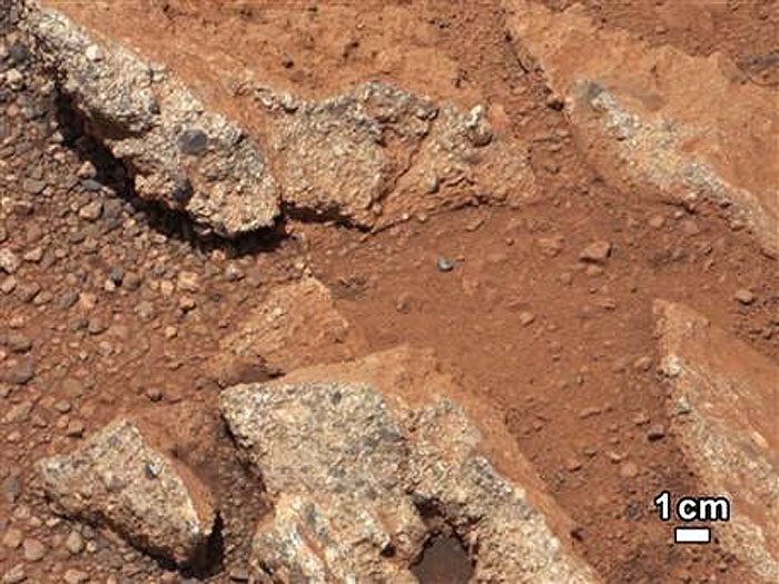
The evidence is in the shape, size and composition of the rocks that Curiosity came across at multiple sites during its landing on Aug. 5. Conglomerate rocks, consisting of pebbles cemented together within layers of sediment, were seen at three sites:
Goulburn, a bedrock formation that was exposed by the blast from Curiosity's descent.
Link, a rock outcrop that was seen once Curiosity headed out from the landing site.
Hottah, an uplifted slab of craggy rock that was given a visual inspection two weeks ago.
Hottah in particular showed clear evidence of rounded pebbles that were too big to be smoothed by the action of the wind. Some of the rocks are as big as golf balls. The best explanation for the gravelly pebbles was that they were eroded by the vigorous flow of water, said Curiosity science team member Rebecca Williams, a senior scientist at the Arizona-based Planetary Science Institute.
The Hottah slab, which measures 4 to 6 inches (10 to 15 centimeters) thick, looks as if "somebody came along the surface of Mars with a jackhammer and lifted up a sidewalk that you might see in downtown LA, sort of like in a construction site," Grotzinger said.
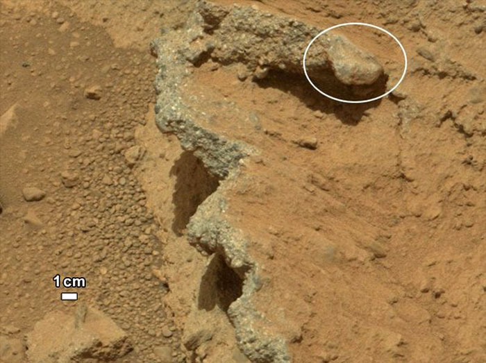
A closeup view of the "Hottah" rock outcrop shows the characteristic pebbly rock that is associated with the action of a flowing stream. Broken surfaces of the outcrop have rounded, gravel clasts, such as the one circled in white, which is about 1.2 inches (3 centimeters) across. The rock formation was named after Hottah Lake in Canada's Northwest Territories.
-
-
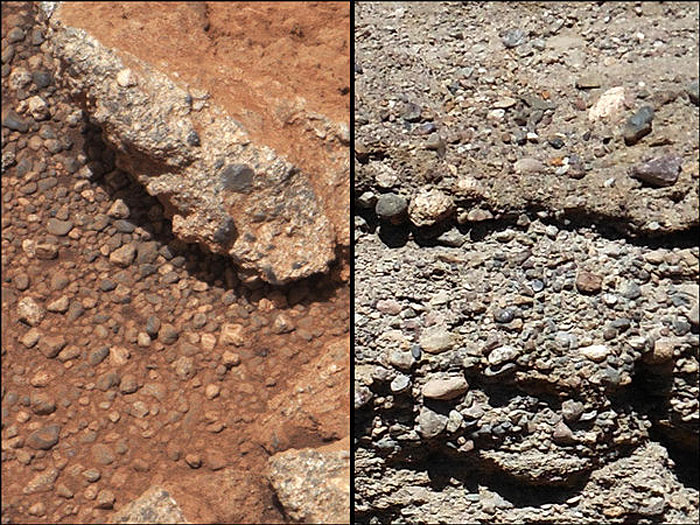
This set of images compares the Link outcrop of rocks on Mars (left) with similar rocks seen on Earth (right). The image of Link, obtained by NASA's Curiosity rover, shows rounded gravel fragments, or clasts, up to a couple of inches (few centimeters) wide, within the rock outcrop. In accordance with the Mars mission's tradition, Link takes its name from a rock formation in Canada's Northwest Territories.
-
The evidence from the ground meshes well with the evidence from orbit indicating that Curiosity is near an 11-mile-wide (18-kilometer-wide) fan of material that may have washed down a channel in ancient times, when Mars was warmer and wetter, according to William Dietrich, a planetary scientist at the University of California at Berkeley.
"These stones ... are very, very revealing to us about the process," Dietrich said. Some previous research has suggested that water flowed on Mars only for brief periods, separated by long, cold, dry spells. That scenario might not have provided enough time for life to get a foothold on the Red Planet in ancient times. But Dietrich said the patterning of the channels within the fan suggested that water streamed through the area for well beyond a thousand-year time scale.
"We can step away from the idea that there was a single burst of water ... that built it all in a day," he told reporters.
Based on the size of the gravel seen by Curiosity, Dietrich estimated that the water moved at a speed of about 3 feet (1 meter) per second, at a depth somewhere between ankle and hip deep.
"Plenty of papers have been written about channels on Mars with many different hypotheses about the flows in them," Dietrich said in a NASA news release. "This is the first time we're actually seeing water-transported gravel on Mars. This is a transition from speculation about the size of streambed material to direct observation of it."
So far, the scientists' conclusions are based exclusively on visual observations by Curiosity's high-resolution Mastcam imager. Further imagery, along with chemical readings from other instruments on the rover, will likely be used to fill out the story of the ancient stream bed, Grotzinger said.
The main goal of Curiosity's two-year primary mission is to assess how habitable Mars was in ancient times. That's why mission managers chose 96-mile-wide (154-kilometer-wide) Gale Crater as Curiosity's landing site. It has that alluvial fan, which appears to issue forth from a channel that has now officially been designated Peace Vallis. It also has a 3-mile-high (5-kilometer-high) mountain, known as Aeolis Mons or Mount Sharp, which could preserve billions of years' worth of Mars' geological record.
Grotzinger noted that the three requirements for habitability typically listed by astrobiologists are the presence of liquid water, the availability of an energy source (such as sunlight) and the presence of carbon-based compounds that can be used as the building blocks of life.
"Now we've got a hall pass for the water examination," Grotzinger joked.
Theoretically, a long-flowing stream could be a habitable environment. "It is not our top choice as an environment for preservation of organics, though," Grotzinger said in NASA's news release. "We're still going to Mount Sharp, but this is insurance that we have already found our first potentially habitable environment."
Even if the rover's instruments detect the right kinds of carbon compounds, that would not serve as confirmation of ancient life on Mars. That would "have to wait for another mission," Grotzinger said.
Quelle: NASA
6660 Views