
17.11.2019
Media representatives and mission partners gathered today in Germany to see a new satellite, which will take the lead in charting sea-level change, before it undergoes final testing and is packed up for shipment to the US for lift-off next year.
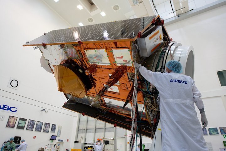
Copernicus Sentinel-6 was on full display at the IABG space test centre near Munich, giving media and partners in the mission a unique opportunity to see this remarkable new satellite up close.
ESA’s Director of Earth Observation Programmes, Josef Aschbacher, said, “We are all extremely proud to see the complete satellite on show here in the cleanroom. With global sea level rising at shocking rates, Copernicus Sentinel-6 will take the lead in providing systematic measurements of sea level so that the worrying trend in sea-level rise can be closely monitored and key information provided for important policy decisions.”
Sentinel-6 is realised thanks to cooperation between ESA, NASA, the European Commission, EUMETSAT and NOAA.
“The mission has been developed thanks to the outstanding international cooperation with our US partners. Sentinel-6 is indeed a model case of pan-European and US–European cooperation, taking advantage of a 26-year history in altimetry measurements from space on both sides of the Atlantic.”
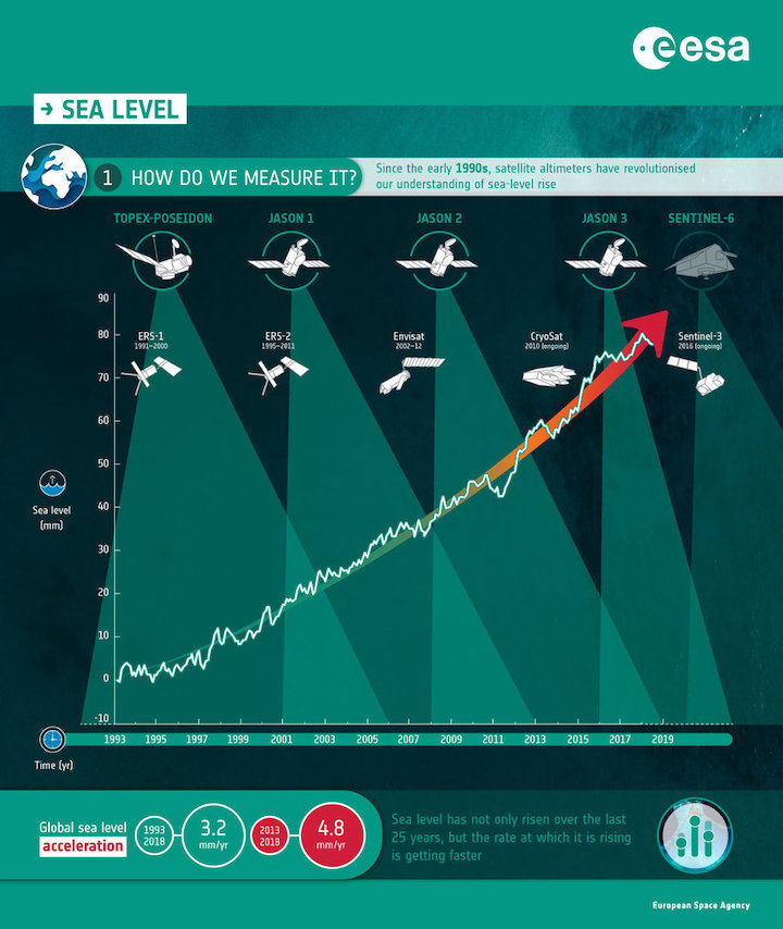
Sentinel-6 builds on heritage from previous ocean topography satellites, including the French–US Topex-Poseidon and Jason missions, previous ESA missions such as the ERS satellites, Envisat and CryoSat, as well as Copernicus Sentinel-3.
These missions have shown how sea level rose by about 3.2 mm on average a year between 1993 and 2018, but more alarmingly, that the rate of rise has been accelerating over the last few years. It is now rising at 4.8 mm a year.
Caused mainly by warming ocean waters, melting glaciers and diminishing ice sheets, sea-level rise is one of the most severe consequences of climate change. With millions of people around the world at risk from rising seas, it is essential to continue measuring the changing height of the sea surface so that decision-makers are equipped to take appropriate mitigating action.
The Copernicus Sentinel-6 satellite will map up to 95% of Earth’s oceans every 10 days. The mission will use a radar altimeter to observe changes in sea-surface topography with centimetre precision, providing insights into global sea levels, the speed and direction of ocean currents and ocean heat storage.
These measurements are not only critical for monitoring our rising seas, but also for climate forecasting, sustainable ocean-resource management, coastal management and environmental protection, the fishing industry, and more.
The Copernicus Sentinel-6 satellite will be launched in November 2020 from the Vandenberg Air Force Base in California, US on a Falcon-9. It will be the first time ESA cooperates, through NASA, with the private US aerospace manufacturer SpaceX, which was founded in 2002 by Elon Musk.
Quelle: ESA
+++
Copernicus Sentinel-6A ready for testing
Dedicated to measuring changes in global sea level, the Copernicus Sentinel-6A satellite is now equipped with some of its measuring instruments and ready to be tested in preparation for liftoff at the end of next year.
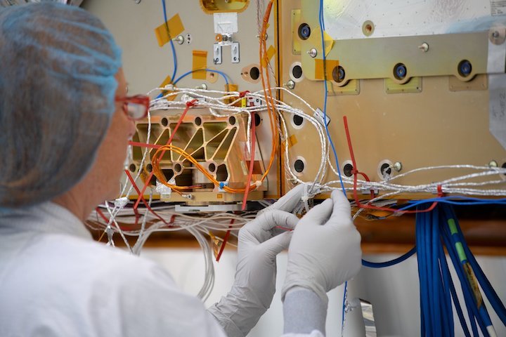
Engineers at Airbus in Friedrichshafen, Germany, have spent the last months fitting out the satellite with state-of-the-art sensors to measure the changing height of the sea surface.
And, since the Copernicus Sentinel-6 mission is a two-satellite constellation they have been working on both Sentinel-6A and Sentinel-6B. The two identical satellites will be launched sequentially, starting with Copernicus Sentinel-6A in November 2020.
Having reached a milestone in its development, this satellite is being shipped to IABG near Munich. Here, Sentinel-6 will spend the next six months being thoroughly tested to ensure that it will withstand the rigours of launch and the harsh environment of space during its life in orbit around Earth.
Pierrik Vuilleumier, ESA’s Copernicus Sentinel-6 project manager, said, “Thanks to Airbus we have passed an important step in the technical development of the mission. The satellite’s altimeter will also be fitted in October.
“While it is one of the European Union’s family of Copernicus satellite missions, which all deliver a wealth of information for a number of environmental services, Copernicus Sentinel-6 is a huge collaborative effort being realised thanks to cooperation between ESA, NASA, NOAA and Eumetsat.”
Over the next decade, the Copernicus Sentinel-6A and then Sentinel-6B will assume roles as reference missions to provide critical data for the long-term record of sea-surface height measurements that have so far been supplied by the French–US Topex-Poseidon and Jason missions.
The 25-year record of altimetry data allows scientists to determine trends. For example, between 1993 and 2018 the global ocean rose 3.2 mm every year, on average.
However, hidden within this average is the fact that the rate of rise has been accelerating – over the last five years the global ocean has risen, on average, 4.8 mm a year.
The Copernicus Sentinel-6 satellites will each carry a radar altimeter, which works by measuring the time it takes for radar pulses to travel to Earth’s surface and back again to the satellite. Combined with precise satellite location data, altimetry measurements yield the height of the sea surface.
The satellites’ instrument package also includes an advanced microwave radiometer that accounts for the amount of water vapour in atmosphere, which affects the speed of the altimeter’s radar pulses.
Copernicus Sentinel-6A is scheduled to be launched on a Falcon-9 rocket from Vandenberg California, US.
Quelle: ESA