
22.03.2022
Exclusive: Experts say the $150m project, due to be de-orbited next year, provides vital data on forests and the carbon stored in them
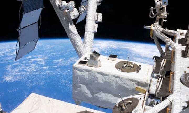
Nasa's Global Ecosystem Dynamics Investigation (Gedi) sensor provided the first 3D map of the world’s forests, providing insights into land-use change, a key driver of biodiversity loss.Photograph: Nasa
Forest experts and scientists are asking Nasa to extend the life of a “key” climate and biodiversity sensor due to be destroyed in the Earth’s atmosphere early next year.
The Global Ecosystem Dynamics Investigation (Gedi) mission – pronounced like Jedi in Star Wars – was launched from the Kennedy Space Center in Florida to the International Space Station (ISS) in December 2018, and has provided the first 3D map of the world’s forests.
Data from the Nasa mission, which has used billions of laser beam signals to measure the height, shape and health of the Earth’s trees since April 2019, has been helping scientists answer questions about land-use change, a key driver of the climate crisis and biodiversity loss, including how much carbon trees store and the effect of forest fires on the atmosphere.
The $150m project is scheduled to be “de-orbited” from the ISS early next year and the sensor – roughly the size of a fridge – will be incinerated in the Earth’s atmosphere.
Researchers overseeing the project, based at the University of Maryland, have asked for an extension to allow Gedi to finish its work and calibrate the results with other satellites due to launch this decade that will monitor the planet’s ecosystems. Early results from the project indicate there could be much more carbon stored on land than previously thought.

While they acknowledge Gedi’s lifetime has already been extended once, in March 2021, the researchers say extensions on the ISS are common and the tool is providing crucial data, including helping to monitor the Cop26 commitment from 142 countries to halt and reverse deforestation by 2030.
“The biggest uncertainty we have in terms of atmospheric CO2 concentrations driving climate change is the balance between deforestation and subsequent regrowth. Gedi is helping us address that,” said Prof Ralph Dubayah, principal investigator on the mission. “If you want to plant a trillion trees, go ahead. But you have to know what you’re starting with to know what kind of impact that’s going to have.”
Leading forest experts have backed calls for a stay of execution. They called the sensor a “key tool” for understanding global heating and described its pending destruction as a waste of money.
When contacted by the Guardian, Nasa said Gedi has already been extended beyond its prime mission to allow for additional data collection and is scheduled to be replaced by another sensor early next year.
Although scientists know the planet’s trees are an enormous carbon store holding the equivalent of nearly a century’s worth of annual fossil fuel emissions at the current rate, basic questions about the size and structure of forests remain unanswered.
