Signs of Life on Mars? NASA’s Perseverance Rover Begins the Hunt
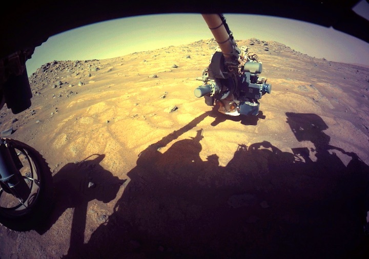
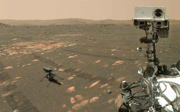
The robotic arm on NASA’s Perseverance rover reached out to examine rocks in an area on Mars nicknamed the “Cratered Floor Fractured Rough” area in this image captured on July 10, 2021 (the 138th sol, or Martian day, of its mission).
Credit: NASA/JPL-Caltech
After testing a bristling array of instruments on its robotic arm, NASA’s latest Mars rover gets down to business: probing rocks and dust for evidence of past life.
NASA’s Mars 2020 Perseverance rover has begun its search for signs of ancient life on the Red Planet. Flexing its 7-foot (2-meter) mechanical arm, the rover is testing the sensitive detectors it carries, capturing their first science readings. Along with analyzing rocks using X-rays and ultraviolet light, the six-wheeled scientist will zoom in for closeups of tiny segments of rock surfaces that might show evidence of past microbial activity.
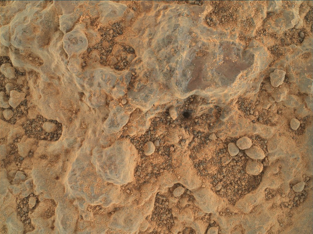
NASA’s Perseverance Mars rover took this close-up of a rock target nicknamed “Foux” using its WATSON camera on the end of the rover’s robotic arm. The image was taken July 11, 2021, the 139th Martian day, or sol, of the mission.
Credit: NASA/JPL-Caltech/MSSS
Called PIXL, or Planetary Instrument for X-ray Lithochemistry, the rover’s X-ray instrument delivered unexpectedly strong science results while it was still being tested, said Abigail Allwood, PIXL’s principal investigator at NASA’s Jet Propulsion Laboratory in Southern California. Located at the end of the arm, the lunchbox-size instrument fired its X-rays at a small calibration target – used to test instrument settings – aboard Perseverance and was able to determine the composition of Martian dust clinging to the target.
“We got our best-ever composition analysis of Martian dust before it even looked at rock,” Allwood said.
That’s just a small taste of what PIXL, combined with the arm’s other instruments, is expected to reveal as it zeroes in on promising geological features over the weeks and months ahead.
“If life was there in Jezero Crater, the evidence of that life could be there,” said Allwood, a key member of the Perseverance “arm science” team.
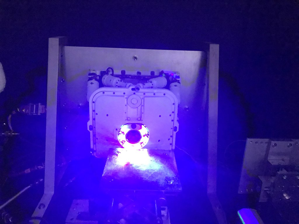
PIXL, one of seven instruments aboard NASA's Perseverance Mars rover, is equipped with light diodes circling its opening to take pictures of rock targets in the dark. Using artificial intelligence, PIXL relies on the images to determine how far away it is from a target to be scanned.
Credit: NASA/JPL-Caltech
To get a detailed profile of rock textures, contours, and composition, PIXL’s maps of the chemicals throughout a rock can be combined with mineral maps produced by the SHERLOCinstrument and its partner, WATSON. SHERLOC – short for Scanning Habitable Environments with Raman & Luminescence for Organics & Chemicals – uses an ultraviolet laser to identify some of the minerals in the rock, while WATSON takes closeup images that scientists can use to determine grain size, roundness, and texture, all of which can help determine how the rock was formed.
Early WATSON closeups have already yielded a trove of data from Martian rocks, the scientists said, such as a variety of colors, sizes of grains in the sediment, and even the presence of “cement” between the grains. Such details can provide important clues about formation history, water flow, and ancient, potentially habitable Martian environments. And combined with those from PIXL, they can provide a broader environmental and even historical snapshot of Jezero Crater.
“What is the crater floor made out of? What were the conditions like on the crater floor?” asks Luther Beegle of JPL, SHERLOC’s principal investigator. “That does tell us a lot about the early days of Mars, and potentially how Mars formed. If we have an idea of what the history of Mars is like, we’ll be able to understand the potential for finding evidence of life.”
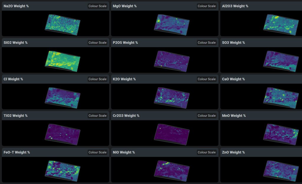
This data shows chemicals detected within a single rock on Mars by PIXL, one of the instruments on the end of the robotic arm aboard NASA’s Perseverance Mars rover. PIXL allows scientists to study where specific chemicals can be found within an area as small as a postage stamp.
Credit: NASA/JPL-Caltech
The Science Team
While the rover has significant autonomous capabilities, such as driving itself across the Martian landscape, hundreds of earthbound scientists are still involved in analyzing results and planning further investigations.
“There are almost 500 people on the science team,” Beegle said. “The number of participants in any given action by the rover is on the order of 100. It’s great to see these scientists come to agreement in analyzing the clues, prioritizing each step, and putting together the pieces of the Jezero science puzzle.”
That will be critical when the Mars 2020 Perseverance rover collects its first samples for eventual return to Earth. They’ll be sealed in superclean metallic tubes on the Martian surface so that a future mission could collect them and send back to the home planet for further analysis.
Despite decades of investigation on the question of potential life, the Red Planet has stubbornly kept its secrets.
“Mars 2020, in my view, is the best opportunity we will have in our lifetime to address that question,” said Kenneth Williford, the deputy project scientist for Perseverance.
The geological details are critical, Allwood said, to place any indication of possible life in context, and to check scientists’ ideas about how a second example of life’s origin could come about.
Combined with other instruments on the rover, the detectors on the arm, including SHERLOC and WATSON, could make humanity’s first discovery of life beyond Earth.
More About the Mission
A key objective for Perseverance’s mission on Mars is astrobiology, including the search for signs of ancient microbial life. The rover will characterize the planet’s geology and past climate, pave the way for human exploration of the Red Planet, and be the first mission to collect and cache Martian rock and regolith (broken rock and dust).
Subsequent NASA missions, in cooperation with ESA (European Space Agency), would send spacecraft to Mars to collect these sealed samples from the surface and return them to Earth for in-depth analysis.
The Mars 2020 Perseverance mission is part of NASA’s Moon to Mars exploration approach, which includes Artemis missions to the Moon that will help prepare for human exploration of the Red Planet.
JPL, which is managed for NASA by Caltech in Pasadena, California, built and manages operations of the Perseverance rover.
Quelle: NASA
----
Update: 23.07.2021
.
NASA Perseverance Mars Rover to Acquire First Sample
A light-colored “paver stone,” like the ones seen in this mosaic image, will be the likely target for first sampling by the Perseverance rover. This image was taken July 8, 2021, in the “Cratered Floor Fractured Rough” geologic unit at Jezero Crater.
Credits: NASA/JPL-Caltech/ASU/MSSS
NASA is making final preparations for its Perseverance Mars rover to collect its first-ever sample of Martian rock, which future planned missions will transport to Earth. The six-wheeled geologist is searching for a scientifically interesting target in a part of Jezero Crater called the “Cratered Floor Fractured Rough.”
This important mission milestone is expected to begin within the next two weeks. Perseverance landed in Jezero Crater Feb. 18, and NASA kicked off the rover mission’s science phase June 1, exploring a 1.5-square-mile (4-square-kilometer) patch of crater floor that may contain Jezero’s deepest and most ancient layers of exposed bedrock.
“When Neil Armstrong took the first sample from the Sea of Tranquility 52 years ago, he began a process that would rewrite what humanity knew about the Moon,” said Thomas Zurbuchen, associate administrator for science at NASA Headquarters. “I have every expectation that Perseverance’s first sample from Jezero Crater, and those that come after, will do the same for Mars. We are on the threshold of a new era of planetary science and discovery.”
It took Armstrong 3 minutes and 35 seconds to collect that first Moon sample. Perseverance will require about 11 days to complete its first sampling, as it must receive its instructions from hundreds of millions of miles away while relying on the most complex and capable, as well as the cleanest, mechanism ever to be sent into space – the Sampling and Caching System.
Precision Instruments Working Together
The sampling sequence begins with the rover placing everything necessary for sampling within reach of its 7-foot (2-meter) long robotic arm. It will then perform an imagery survey, so NASA’s science team can determine the exact location for taking the first sample, and a separate target site in the same area for “proximity science.”
“The idea is to get valuable data on the rock we are about to sample by finding its geologic twin and performing detailed in-situ analysis,” said science campaign co-lead Vivian Sun, from NASA's Jet Propulsion Laboratory in Southern California. “On the geologic double, first we use an abrading bit to scrape off the top layers of rock and dust to expose fresh, unweathered surfaces, blow it clean with our Gas Dust Removal Tool, and then get up close and personal with our turret-mounted proximity science instruments SHERLOC, PIXL, and WATSON.”
SHERLOC (Scanning Habitable Environments with Raman & Luminescence for Organics & Chemicals), PIXL (Planetary Instrument for X-ray Lithochemistry), and the WATSON (Wide Angle Topographic Sensor for Operations and eNgineering) camera will provide mineral and chemical analysis of the abraded target. Perseverance’s SuperCam and Mastcam-Z instruments, both located on the rover’s mast, will also participate. While SuperCam fires its laser at the abraded surface, spectroscopically measuring the resulting plume and collecting other data, Mastcam-Z will capture high-resolution imagery.
Working together, these five instruments will enable unprecedented analysis of geological materials at the worksite.
“After our pre-coring science is complete, we will limit rover tasks for a sol, or a Martian day,” said Sun. “This will allow the rover to fully charge its battery for the events of the following day.”
Sampling day kicks off with the sample-handling arm within the Adaptive Caching Assembly retrieving a sample tube, heating it, and then inserting it into a coring bit. A device called the bit carousel transports the tube and bit to a rotary-percussive drill on Perseverance’s robotic arm, which will then drill the untouched geologic “twin” of the rock studied the previous sol, filling the tube with a core sample roughly the size of a piece of chalk.
Perseverance’s arm will then move the bit-and-tube combination back into bit carousel, which will transfer it back into the Adaptive Caching Assembly, where the sample will be measured for volume, photographed, hermetically sealed, and stored. The next time the sample tube contents are seen, they will be in a clean room facility on Earth, for analysis using scientific instruments much too large to send to Mars.
“Not every sample Perseverance is collecting will be done in the quest for ancient life, and we don’t expect this first sample to provide definitive proof one way or the other,” said Perseverance project scientist Ken Farley, of Caltech. “While the rocks located in this geologic unit are not great time capsules for organics, we believe they have been around since the formation of Jezero Crater and incredibly valuable to fill gaps in our geologic understanding of this region – things we’ll desperately need to know if we find life once existed on Mars.”
More About the Mission
A key objective for Perseverance’s mission on Mars is astrobiology, including the search for signs of ancient microbial life. The rover will characterize the planet’s geology and past climate, pave the way for human exploration of the Red Planet, and be the first mission to collect and cache Martian rock and regolith.
The Mars 2020 Perseverance mission is the first step in NASA’s Mars Sample Return Campaign. Subsequent NASA missions, now in development in cooperation with the European Space Agency, would send spacecraft to Mars to collect these sealed samples from the surface and return them to Earth for in-depth analysis.
The Mars 2020 Perseverance mission is part of NASA’s Moon to Mars exploration approach, which includes Artemis missions to the Moon that will help prepare for human exploration of the Red Planet.
Quelle: NASA
----
Update: 30.07.2021
.
Ingenuity completes 10th flight on Mars, Perseverance starts search for life
On July 24, 2021, NASA’s Ingenuity Mars helicopter successfully completed its 10th and most daring flight on the red planet — a major milestone for the Ingenuity mission. The helicopter, originally expected to only perform five flights on Mars, continues to assist the Perseverance rover as hoped.
Meanwhile, Perseverance itself recently began full science operations at Jezero Crater. Rover teams are finalizing testing onboard the science platform and beginning the search for signs of life on Mars.
Perseverance placed Ingenuity onto the surface of Mars on April 3 at a location designated “Wright Brothers Field.” Ingenuity teams then began a series of tests with the helicopter to ensure it was in good shape to begin flying.
After completing rotor tests and surviving Martian nights, Perseverance drove to Van Zyl Overlook to observe Ingenuity’s first flight. Overcoming a command sequence issue, Ingenuity performed the first powered flight of any aircraft on another planet on April 19, 2021.
Flight 1, a demonstration hop, consisted of a simple vertical takeoff, an ascent to three meters, a stable hover for 30 seconds, a 90-degree turn, and a descent back to the surface. The flight lasted a total of 39.1 seconds and was a complete success.
Ingenuity (left, center), seen after landing on May 7 by Perseverance’s Mastcam-Z imager. (Credit: NASA/JPL-Caltech/ASU/MSSS)
Ingenuity’s teams began preparing for the second flight, and just three days after the first flight, the helicopter successfully performed its second.
Flight 2 consisted of a vertical takeoff, an ascent to five meters, a hover, a sideways divert of two meters to the east, a 276 degree counterclockwise turn, a divert maneuver two meters to the west, and a descent. The flight lasted 51.9 seconds, and Ingenuity traveled at a speed of 0.5 m/s.
In a continued effort to try and stay within the helicopter’s 30 day test window, Ingenuity teams began preparing for the third flight — the third in less than a week.
Flight 3 was performed on April 25 and consisted of a vertical ascent to five meters, a hover, a northward divert of 50 meters, a hover, a southward divert of 50 meters, a hover, and a descent. The flight lasted 80.3 seconds with Ingenuity traveling at 2 m/s over a total distance of 100 meters.
During the flight, Ingenuity was able to capture an image of Perseverance observing it in the distance. With this flight, JPL announced that Ingenuity had met or surpassed all of the test goals set for the helicopter’s tech demonstration and that it would begin performing more daring flights to push the limits of its design.
Ingenuity’s fourth flight was scheduled for April 29; however, no flight occurred. Upon investigation, Ingenuity teams found that the helicopter did not successfully transition into flight mode. As a result, Flight 4 was rescheduled for April 30.
Flight 4 eventually consisted of a takeoff, an ascent to five meters, a hover, a southward divert of 133 meters, a hover, a northward divert of 133 meters, a hover, and a descent. Ingenuity traveled 266 meters roundtrip at a top speed of 3.5 m/s over 117 seconds.
Up through flight four, the helicopter performed all of its takeoffs and landings at the same location: Wright Brothers Field. However, Flight 5 would see Ingenuity land in a separate location.
On May 7, Ingenuity successfully performed this flight with a 110 second travel time and a maximum velocity of 2 m/s across 129 meters distance while maintaining 10 meters altitude above the local terrain.
This flight also marked the end of Ingenuity’s technology demonstration phase, as the helicopter had not just met but surpassed all of its pre-mission planned objectives.
Flight 6 marked the first time Ingenuity landed in an area it had not previously surveyed from the air.
When Ingenuity lands in previously not surveyed regions, teams rely on HiRISE camera image data from the Mars Reconnaissance Orbiter to ensure the location meets the helicopter’s landing and take off specifications.
However, during Flight 6, Ingenuity encountered an in-flight anomaly. The first southwesterly divert was performed as planned, but approximately 54 seconds into flight, the vehicle began rapidly changing velocity and became somewhat unstable as well.
Ingenuity was able to self-correct, stay airborne, and later land just five meters from its intended touchdown area. The anomaly was traced to the helicopter’s camera navigation system marking images with the incorrect timestamps.
Following the in-flight anomaly, Flight 7 occurred on June 8, after a failed attempt on June 6 due to the same reason Flight 4 failed.
Flight 7 consisted of a takeoff, an ascent to 10 meters, a 106 meter divert to the south, a descent, and a landing in a new location, Airfield D. This flight did not use the helicopter’s camera navigation system to avoid the glitch that caused the Flight 6 anomaly.
Two weeks after Flight 7, Ingenuity successfully performed its eighth flight on June 22. The flight, which lasted 78 seconds, consisted of a takeoff from Airfield D, an ascent to 10 meters, a divert of 160 meters to the southeast, a descent, and a landing.
Like Flight 7, Ingenuity’s camera navigation system was not used during flight 8 to avoid the Flight 6 anomaly.
In pursuit of pushing the envelope even more, Flight 9 was set to be Ingenuity’s most daring flight to that time.
The helicopter, which had only traveled 266 meters in a single flight, was set to travel 625 meters southwest across the Séítah area. The flight consisted of a takeoff from Airfield E, ascent to 10 meters, a southwesterly divert of 625 meters in which a maximum velocity of 5 m/s was recorded, a descent, and a landing.
Ingenuity successfully completed the prolonged flight on July 5, and although it landed slightly short of its intended touchdown location, it managed, with this flight, to exceed the total distance the Perseverance rover itself had travel across the Martian terrain since landing.
At the completion of Flight 9, Ingenuity had an odometer reading of just over 1,600 meters, just slightly edging out Perseverance.
Flight 10 sought to introduce more complication into the flight plan, with Ingenuity set to travel to 10 different waypoints to allow its camera to gather images of an outcrop the rover team is looking to investigate.
Flight 10 occurred on July 24 and consisted of a takeoff, an ascent to 12 meters (a new Mars altitude record), a 50 meter divert to the southwest, a sideways translation to the west, a northwesterly divert, a divert to the northeast, a descent, and a landing in a new airfield.
According to Ingenuity’s teams, the helicopter remains in good health and is expected to keep flying until a major anomaly or issue prevents the rotorcraft from doing so.
“We are putting the rover’s commissioning phase as well as the landing site in our rearview mirror and hitting the road,” said Jennifer Trosper, Perseverance project manager at NASA’s Jet Propulsion Laboratory.
The two locations scientists are looking to study first are the Séítah area and the Crater Floor Fractured Rough area. Séítah, meaning “amidst the sand” in Navajo, is a unique geologic area with various characteristics including dunes, bedrock, ridges, and layered rocks.
The Crater Floor Fractured Rough area is comprised of bedrock and is the crater-filled floor of Jezero Crater. Here, Perseverance is expected to drill and collect its first sample of the Martian soil.
A diagram with the instrument locations on Perseverance (Credit: NASA/JPL)
Once the rover has finished investigating these two areas, it will return to its landing site, where it will then drive north to begin its second science campaign.
Throughout the early portions of its mission, Perseverance will be aided by Ingenuity, which at this point is functioning as a scout for the rover. As part of Ingenuity’s operations demonstration phase, the helicopter has so far provided useful color imagery of areas of geologic interest to scientists.
One such area is “Raised Ridges” — a rocky outcrop of a geologic fracture system. During Ingenuity’s ninth flight, it flew over the area and took high-definition imagery of the outcrop. Using these images, Perseverance’s planning teams now have a better understanding of where to go and where to look for certain features on the Rocky Ridges that may be of biological importance or significance.
Part of Perseverance’s unique ability to travel and perform science stems from its 2-meter long robotic arm. At the end of this arm is a suite of instruments — including a drill, camera, and X-ray — that Perseverance can use to study the Martian surface in extreme detail.
Following extensive checkouts on Mars, the robotic arm has been cleared for full science operations, allowing Perseverance to begin fulfilling its purpose — investigating, in-situ, the Martian environment with a specific goal of searching for signs of past and present life on the Red Planet.
To fulfill this goal, Perseverance will use its drill and robotic arm to collect and store samples of the Martian surface. Using its plethora of instruments, Perseverance will analyze the area of the surface where the sample will be collected before the rover’s Adaptive Caching Assembly retrieves a sample tube from inside the rover.
The Adaptive Caching Assembly will heat the tube and then insert it into a coring bit. The bit will then be transferred to the drill on the robotic arm. The drill will then slowly lower to the surface and extract a portion of material. Meanwhile, the sample tube will collect the soil, dust, and rock. Once complete, the sample in the tube should be roughly the size of a piece of chalk.
The tube will then be inserted back into the rover, where instruments will analyze it before storing it safely inside Perseverance.
The sample tubes collected by the Sample Fetch Rover will be returned to Earth via a Northrop Grumman-built Mars Ascent Vehicle (a solid motor rocket that will be launched with the Sample Fetch Rover) which will meet a ESA-provided Earth Return Orbiter and capsule in Martian orbit. The orbiter will then collect the samples and return them to Earth where they can be examined thoroughly with unique instruments Perseverance cannot carry.
The ESA Earth Return Orbiter, the third of the three Mars Sample Return flights, is slated to launch in October 2026 on an Ariane 6 rocket from French Guiana three months after the Mars Ascent Vehicle and Sample Fetch Rover are scheduled to be launched from the United States.
Quelle: NS
----
Update: 6.08.2021
.
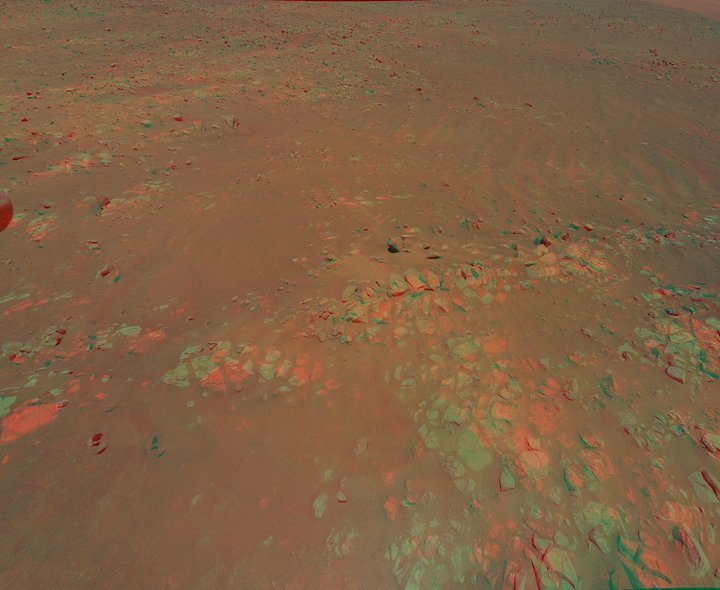
My Favorite Martian Image: Helicopter Scouts Ridge Area for Perseverance
This 3D view of geologic feature the Mars Perseverance rover team calls Raised Ridges was generated from data collected by Ingenuity during its 10th flight at Mars, on July 24, 2021.
Credit: NASA/JPL-Caltech
A member of the Perseverance rover’s science team explains why the aerial image offers science advantages over ground-level images.
Ask any space explorer, and they’ll have a favorite photo or two from their mission. For Kevin Hand, a scientist at NASA’s Jet Propulsion Laboratory in Southern California and co-lead of the Perseverance rover’s first science campaign, his latest favorite is a 3D image of low-lying wrinkles in the surface of Jezero Crater. The science team calls this area “Raised Ridges.” NASA’s Ingenuity Mars Helicopter captured the two shots for this stereo image on July 24 during its 10th flight.
“Ingenuity is allowing the Perseverance science team to be in two places at once,” said Hand. “Right now, we are at the ‘Crater Floor Fractured Rough,’ where the rover is preparing for the mission’s first sample acquisition on Mars. Yet at the same time, Ingenuity is providing a detailed preview of a potentially intriguing geologic features hundreds of meters away from us.”
The Return to Earth camera on NASA's Ingenuity Mars Helicopter snapped this picture of geologic feature the Mars Perseverance rover team calls "Raised Ridges" during its 10th flight at Mars, on July 24, 2021.
The Raised Ridges intrigue Hand and his colleagues because they consist of three distinct surface fractures that converge at a central point. On Earth, similar fractures in desert environments might be a clue to past liquid water activity and thus past habitability. The Perseverance science team wants to know if what is good for the third rock from the Sun is good for Mars – and if so, whether the Raised Ridges tell them something significant about Mars’ watery past.
“If you look closely, you can see some curious lines across the surfaces of several rocks.”
Perseverance science team member Kevin Hand
Ingenuity captured the images during its most complex flight yet. After taking off from its seventh airfield, it climbed to a new record altitude of 40 feet (12 meters). The helicopter then made four heading changes and took 10 images with the rotorcraft’s color camera before landing at a new airfield. The 3D image was created by combining two of those images, offering the rover team a richer perspective as they plan the next steps in their science campaign.
“In 3D it almost feels like you can reach out and touch the Raised Ridges,” said Hand. “But along with its immersive beauty, the image provides great detail. If you look closely, you can see some curious lines across the surfaces of several rocks. Are these just made by eons of wind and dust blowing over the rocks, or might those features tell the story of water? We just don’t know yet.”
Those details are important. In their search for signs of ancient life on Mars, the team is considering drilling a rock or sediment sample in the Raised Ridges, which would take several Martian days, or sols, of driving to reach. With Ingenuity’s images, the rover team now has a much better idea of what to expect if they were to go there and the science value of doing so. In the weeks to come, the science team will pour over this and other 3D images from Ingenuity and debate the merits of such a visit.
“Since landing at Jezero Crater, it’s clear to all of us that there is an abundance of geologic riches for us to explore. It’s a good problem to have,” said Ken Williford, deputy project scientist for Perseverance at JPL. “These aerial previews from Ingenuity provide the kind of actionable data that allow us to whittle down our options and get on with the business of exploring our corner of Mars.”
More About the Mission
A key objective for Perseverance’s mission on Mars is astrobiology, including the search for signs of ancient microbial life. The rover will characterize the planet’s geology and past climate, pave the way for human exploration of the Red Planet, and be the first mission to collect and cache Martian rock and regolith (broken rock and dust).
Subsequent NASA missions, in cooperation with ESA (European Space Agency), would send spacecraft to Mars to collect these sealed samples from the surface and return them to Earth for in-depth analysis.
The Mars 2020 Perseverance mission is part of NASA’s Moon to Mars exploration approach, which includes Artemis missions to the Moon that will help prepare for human exploration of the Red Planet.
JPL, which is managed for NASA by Caltech in Pasadena, California, built and manages operations of the Perseverance rover.
Quelle: NASA
----
Update: 6.08.2021
.
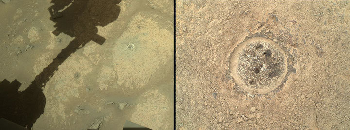
On the Eve of Perseverance’s First Sample Written by Louise Jandura, Chief Engineer for Sampling & Caching at NASA/JPL
NASA's Mars Perseverance rover acquired the left image using its onboard Right Navigation Camera (Navcam). The right image was acquired using its onboard SHERLOC WATSON camera. Both images were taken on Aug. 2, 2021 (Sol 160). Credits: NASA/JPL-Caltech. Left image | Right image
A few sols ago Perseverance performed the first science abrasion on the target Guillaumes. All reveled in the engineering success but what was revealed below the surface of the rock after the dust was cleared away surprised us. The science team has been intrigued and excited as they study this patch – what more could we as engineers have hoped for!
So now we are poised to take the first sample nearby this abraded patch – the first of about 35 rock samples that we hope will be brought back to Earth by future missions. I am the Sampling & Caching Chief Engineer and I have been thinking about and preparing for this day for nearly 8 years now but today it feels like just yesterday we were figuring out the design architecture for Sampling & Caching that we would take forward into the detailed design process. In reality it was a long, intense, challenging, and exhilarating road that resulted in the sophisticated robotic hardware that is Perseverance. Traveling that tough road together molded our partnership with the science team and formed the amazing group of people that are able to operate this marvelous machine on a daily basis in the service of science. The team never ceases to amaze me. They are brilliant and hardworking, dedicated to excellence, and above all joyful to be a part of this historic mission. I am so proud to be a part of this team.
Today we are hard at work planning for the first sample acquisition and end-to-end processing resulting in a sample enclosed in its hermetically sealed tube. Later today the commands to Perseverance will be sent and the waiting begins. The data will begin to trickle in during the middle of the night and the team will be up anxiously awaiting the first bits of information on how things have gone up to that point. The waiting will extend well into tomorrow until the final bits are down.
I do not wait alone and that comforts me…stay tuned and we will give you an update tomorrow afternoon.
Quelle: NASA
----
Update: 8.08.2021
.
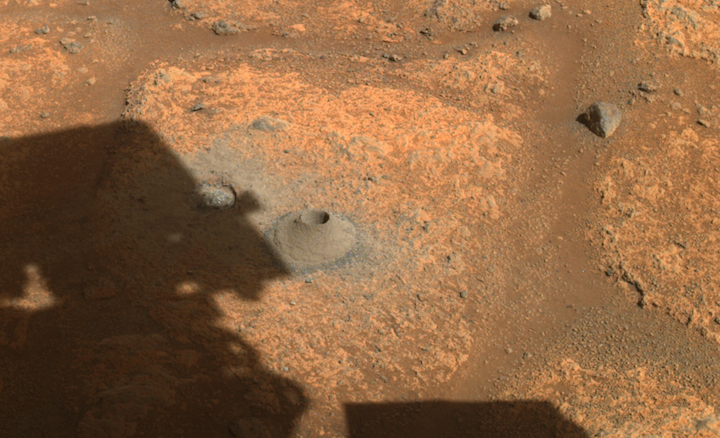
NASA’s Perseverance Team Assessing First Mars Sampling Attempt
This image taken by one the hazard cameras aboard NASA’s Perseverance rover on Aug. 6, 2021, shows the hole drilled in what the rover’s science team calls a “paver rock” in preparation for the mission’s first attempt to collect a sample from Mars.
Credits: NASA/JPL-Caltech
Data sent to Earth by NASA’s Perseverance rover after its first attempt to collect a rock sample on Mars and seal it in a sample tube indicate that no rock was collected during the initial sampling activity.
The rover carries 43 titanium sample tubes, and is exploring Jezero Crater, where it will be gathering samples of rock and regolith (broken rock and dust) for future analysis on Earth.
“While this is not the ‘hole-in-one’ we hoped for, there is always risk with breaking new ground,” said Thomas Zurbuchen, associate administrator of NASA’s Science Mission Directorate in Washington. “I’m confident we have the right team working this, and we will persevere toward a solution to ensure future success.”
Perseverance’s Sampling and Caching System uses a hollow coring bit and a percussive drill at the end of its 7-foot-long (2-meter-long) robotic arm to extract samples. Telemetry from the rover indicates that during its first coring attempt, the drill and bit were engaged as planned, and post-coring the sample tube was processed as intended.
“The sampling process is autonomous from beginning to end,” said Jessica Samuels, the surface mission manager for Perseverance at NASA’s Jet Propulsion Laboratory in Southern California. “One of the steps that occurs after placing a probe into the collection tube is to measure the volume of the sample. The probe did not encounter the expected resistance that would be there if a sample were inside the tube.”
The Perseverance mission is assembling a response team to analyze the data. One early step will be to use the WATSON (Wide Angle Topographic Sensor for Operations and eNgineering) imager – located at the end of the robotic arm – to take close-up pictures of the borehole. Once the team has a better understanding of what happened, it will be able to ascertain when to schedule the next sample collection attempt.
“The initial thinking is that the empty tube is more likely a result of the rock target not reacting the way we expected during coring, and less likely a hardware issue with the Sampling and Caching System,” said Jennifer Trosper, project manager for Perseverance at JPL. “Over the next few days, the team will be spending more time analyzing the data we have, and also acquiring some additional diagnostic data to support understanding the root cause for the empty tube.”
Previous NASA missions on Mars have also encountered surprising rock and regolith properties during sample collection and other activities. In 2008, the Phoenix mission sampled soil that was "sticky" and difficult to move into onboard science instruments, resulting in multiple tries before achieving success. Curiosity has drilled into rocks that turned out to be harder and more brittle than expected. Most recently, the heat probe on the InSight lander, known as the “mole,” was unable to penetrate the Martian surface as planned.
“I have been on every Mars rover mission since the beginning, and this planet is always teaching us what we don’t know about it,” said Trosper. “One thing I’ve found is, it’s not unusual to have complications during complex, first-time activities.”
First Science Campaign
Perseverance is currently exploring two geologic units containing Jezero Crater’s deepest and most ancient layers of exposed bedrock and other intriguing geologic features. The first unit, called the “Crater Floor Fractured Rough,” is the floor of Jezero. The adjacent unit, named “Séítah” (meaning “amidst the sand” in the Navajo language), has Mars bedrock as well, and is also home to ridges, layered rocks, and sand dunes.
Recently, the Perseverance science team began using color images from the Ingenuity Mars Helicopter to help scout for areas of potential scientific interest and to look for potential hazards. Ingenuity completed its 11th flight Wednesday, Aug. 4, traveling about 1,250 feet (380 meters) downrange of its current location so that it could provide the project aerial reconnaissance of the southern Séítah area.
The rover’s initial science foray, which spans hundreds of sols (or Martian days), will be complete when Perseverance returns to its landing site. At that point, Perseverance will have traveled between 1.6 and 3.1 miles (2.5 and 5 kilometers) and may have filled up to eight of its sample tubes.
Next, Perseverance will travel north, then west, toward the location of its second science campaign: Jezero Crater’s delta region. The delta is the fan-shaped remains of the confluence of an ancient river and a lake within Jezero Crater. The region may be especially rich in carbonate minerals. On Earth, such minerals can preserve fossilized signs of ancient microscopic life and are associated with biological processes.
More About the Mission
A key objective for Perseverance’s mission on Mars is astrobiology, including the search for signs of ancient microbial life. The rover will characterize the planet’s geology and past climate, pave the way for human exploration of the Red Planet, and be the first mission to collect and cache Martian rock and regolith.
Subsequent NASA missions, in cooperation with ESA (European Space Agency), would send spacecraft to Mars to collect these sealed samples from the surface and return them to Earth for in-depth analysis.
The Mars 2020 Perseverance mission is part of NASA’s Moon to Mars exploration approach, which includes Artemis missions to the Moon that will help prepare for human exploration of the Red Planet.
JPL, which is managed for NASA by Caltech in Pasadena, California, built and manages operations of the Perseverance rover.