
.
The 701 Club
Case #8388 - June 15, 1963
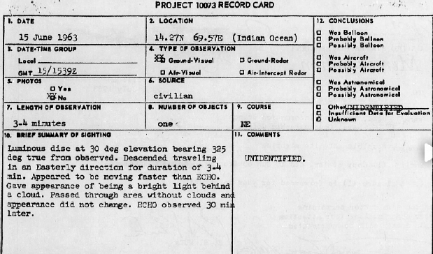
The Blue Book record
The file is rather small. Besides the record card, there is a letter with a sketch from the witness. A memo was also enclosed asking NASA to look into the matter as a possible satellite sighting. Apparently, NASA did not respond or the response was lost.1
While there is not much in the file, the witness’ sketch and description contained specific information that could help solve the case.
How UFOlogists list the case
The two main listings of the Blue Book unknowns were compiled by Brad Sparks and Don Berliner. Berliner’s list on the NICAP web site describes the case as follows:
June 15, 1963; 200 miles north of Venezuela (14° 27’ N., 69° 57’ E.). 10:39 a.m. Witness: 3rd Mate R.C. Chamberlin, of S/ Thetis. One luminous
disc traveled at 1.5 times the speed of satellite for 3-4 minutes. 2
Brad Sparks’ catalogue can be found at the CUFOS web site. His description is almost the same as Berliner’s:
June 15, 1963. About 200 miles N of Venezuela (at 14°17’ N, 69°57’ W). 10:39 a.m. 3rd Mate . C. Chamberlin, of S/ [SS?] Thetis saw luminous disc travel at 1.5 times the angular speed of a satellite. (Sparks; Berliner) 3-4 mins 3
Sparks appears to have copied Berliner’s entry but also listed his own personal research on this case as a source. As one can see above, there is a gross error here regarding the location of the witness in both entries. The Blue Book record card clearly states that the longitude was East longitude and the ship was in the Indian Ocean. Berliner got the longitude correct but seems to have plotted it incorrectly giving a postion north of Venezuela. Sparks seems to have then noted the descrepency regarding Venezuela and East longitude. As a result, he appears to have changed the longitude to West longitude (I assume changing the latitude from 27’ to 17’ was a typo) to match this location. It was a case of compounding errors instead of looking at the source documentation. There is no doubt that the witness was in the Indian Ocean as his letter, dated June 19th, is addressed from Ras Tanura, Saudia Arabia. He also gave his location of the sighting as East longitude.
Analysis
Reading the statement of the witness, he describes the following:
At 151539GMT a luminous disc was observed at an altitude of approximately 30 degrees bearing about 325 degrees true from the observer. It was descending traveling in an easterly direction and was in sight for about three to four minutes from the time of the first sighting. When first seen it was close below Dubhe and passed close west of Polaris disappearing beyond the horizon almost directly below Polaris. It was difficult to estimate the height but appeared very high. It appeared to be traveling a little faster than the US satellite “Echo” behind a light filiment(sic) of cloud. However, it was observed to be passing through an area with no clouds but never changing its first appearance. About 30 minutes after it passe (sic) “Echo” passed over and disappeared in nearly the same location. 4
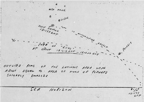
He added that three others saw the event and all agreed with the statement. The witness included the following sketch with his report: 5
It is interesting to see how the witness’ description of the UFO is interpreted by the UFOlogists in their catalogues. Both Sparks and Berliner declare that the object had 1.5 times the angular speed of a satellite. That just means the object, if it was in orbit, was at a lower orbit than Echo-I. What seems to have been missed by these UFOlogists, is the fact that the Echo-1 Satellite had an orbit with an altitude of about 1000 miles! Its angular speed was slower than most satellites visible to the naked eye. This indicates the claim that it had an angular speed 1.5 times a satellite was misleading. It gave the false impression that it was not a satellite when the actual angular speed was what one would expect from a satellite in low earth orbit.
The observations of the witness did not indicate the pin point of light one would expect from a satellite. Instead, his sketch indicated an angular size of about one-quarter to one-half of a degree. To me, his observations sounded like a rocket venting fuel in low earth orbit.
.
Following this idea, I checked the Astronautix chronology to see if there were any recent rocket launches.
Astronautix web site to the rescue
I was pleasantly surprised to see this entry:
1963 June 15 - . 14:29 GMT - . Launch Site: Vandenberg. Launch Complex: Vandenberg SLC2E. LV Family: Delta. Launch Vehicle: Thor Agena D. LV Configuration: Thor Agena D 378 / Agena D 2353.
Lofti 2A - . Mass: 26 kg (57 lb). Nation: USA. Agency: USN. Class: Technology. Type: Communications technology satellite. Spacecraft: • Lofti. Decay Date: 1963-07-18 . USAF Sat Cat: 601 . COSPAR: 1963-021B. Apogee: 876 km (544 mi). Perigee: 170 km (100 mi). Inclination:
69.9000 deg. Period: 95.10 min. Summary: VLF experiments. Space craft engaged in investigation of spaceflight techniques and technology (US Cat A). .
USN satellite - . Payload: NRL PL130?. Mass: 35 kg (77 lb). Nation: USA. Agency: USN. Program: ELINT. Class: Military. Type: Military na•
val signals reconnaisance satellite. Spacecraft: NRL ELINT. Decay Date: 1963-07-27 . USAF Sat Cat: 598 . COSPAR: 1963-021E. Apogee: 859 km (533 mi). Perigee: 170 km (100 mi). Inclination: 69.9000 deg. Period: 94.90 min. Summary: Identified by McDowell as probable NRL ELINT satellite..

RADOSE 112 - . Payload: NRL PL 112. Mass: 25 kg (55 lb). Nation: USA. Agency: USN. Class: Earth. Type: Magnetosphere satellite. Space•
craft: RADOSE. Decay Date: 1963-07-30 . USAF Sat Cat: 600 . COSPAR: 1963-021D. Apogee: 875 km (543 mi). Perigee: 170 km (100 mi). Inclination: 69.9000 deg. Period: 95.10 min. Summary: Radiation dosimeter measurements. Space craft engaged in investigation of spaceflight techniques and technology (US Cat A). .
SURCAL 1B - . Mass: 3.00 kg (6.60 lb). Nation: USA. Agency: USN. Class: Military. Type: Radar calibration target. Spacecraft: SURCAL. • Decay Date: 1963-07-05 . USAF Sat Cat: 597 . COSPAR: 1963-021F. Apogee: 802 km (498 mi). Perigee: 172 km (106 mi). Inclination: 69.9000 deg. Period: 94.40 min. Summary: Surveillance Calibration. Space craft engaged in investigation of spaceflight techniques and technology (US Cat A). .
SOLARED-Satellite
Solrad 6A - . Mass: 39 kg (85 lb). Nation: USA. Agency: USN. Class: Military. Type: Military naval signals reconnaisance satellite. Space•
craft: GRAB. Decay Date: 1963-08-01 . USAF Sat Cat: 599 . COSPAR: 1963-021C. Apogee: 869 km (539 mi). Perigee: 170 km (100 mi). Inclination: 69.9000 deg. Period: 95.10 min. Summary: Solar radiation data. Space craft engaged in investigation of spaceflight techniques and technology (US Cat A). 6
This rocket launch was half-a-world away (roughly 190 degrees of longitude) and roughly seventy minutes before the sighting. Considering the inclination of 69.9 degrees, the time for the rocket to get up to orbital speed, and the final orbit being 95 minutes, I considered it very likely that the rocket would be in the vicinity of the ship at the time of the sighting.
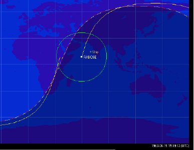
My next step was to run a rough model using the TLE (Two line elements) from one of the satellites (in this case the RADOSE) and Orbitron software. I obtained results, which indicated the satellite was over the Indian ocean at the time of the event. This appeared to indicate I was on the right track.
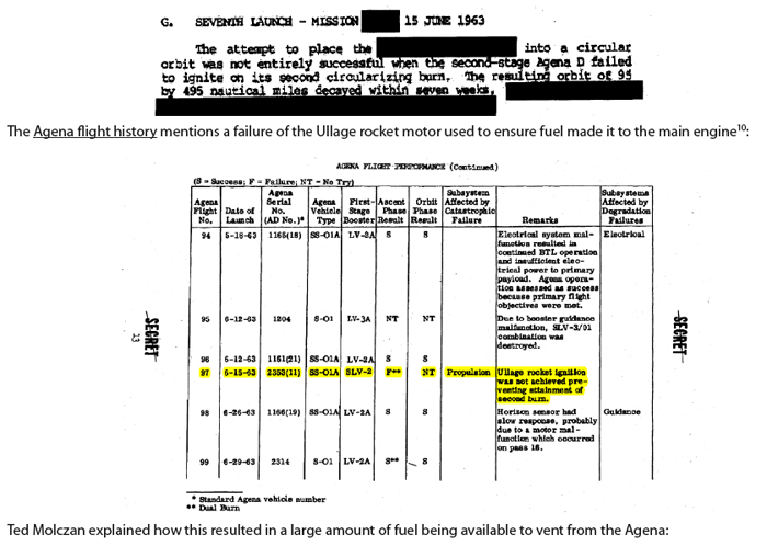
After a bit of looking through several documents on the web, I discovered that the launch was not a complete success. 7
The failure to reach proper orbit inidcated a failed second stage, which would have been on a similar ground track as the satellites this early after launch. Looking for additional information, I asked for help from James Oberg and Robert Sheaffer, who forwarded my request to Ted Molczan.
The solution confirmed
Ted Molczan’s response was to congratulate me on my find and gave me several references to examine as well as a TLE for the Agena stage and the Echo satellite. He stated:
I have obtained the TLEs of the 1963-021 launch and Echo 1, closest in epoch to the reported time of the sighting, and they correlate with the description and sketch beautifully.8
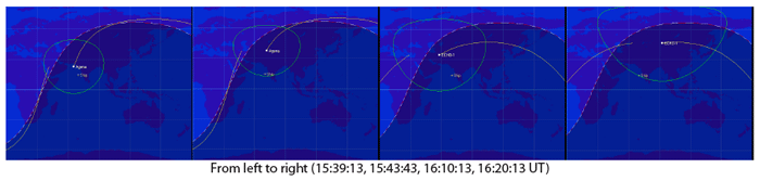
When using this TLEs for the Agena and the Echo-1 satellite, we see the following tracks:
Ted pointed out to me that the only object that would have been visible would have been the Agena stage because the satellites themselves were too small. He also discovered more information about the problems with the second stage. In the TOP SECRET History of the POPPY satellite system (one of the satellites that was launched), we read the following9:
The launch in question was a partial failure, in that the second stage (Agena D 2353) failed to circularize the orbit at apogee….The first passage through apogee occurred at about 15:24 UTC, just 15 min prior to the sighting. Based on the description, I speculate that the observed phenomenon may have been the venting of unspent propellant….A quick review of a few technical documents from the mid to late ‘60s reveals that an optional propellant dump package was available for the Agena D. Whether that was installed on Agena D 2353, I do not know. If it was, then I believe that the dump would have been in progress by the time of the sighting, and given the failure to perform the final burn, there would have been plenty of oxidizer and fuel to vent.11
The resultant cloud of gas surrounding the Agena would create an object of significant angular size that would appear as a “luminous disc” to the observer on the ship.
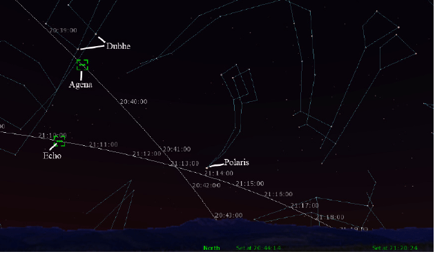
Heavensat’s track across the sky
Using Heavensat, I was able to visualize the tracks across the sky of both the Echo and Agena to see how well they compared with the sketch provided by the witness (times are local time - GMT + 5 hours):
Seeing this plot sealed the deal for me. In my opinion, the UFO was the Agena stage venting fuel.
Why didn’t Blue Book solve this?
As always, it seems that complacency and lack of manpower may have prevented the identification of this source. Blue Book suspected
that it might be a satellite but could not verify it. Because the satellites were classified (POPPY was not declassified until 2005), NASA may have chosen not to inform Blue Book. It is also possible that NASA may have not bothered to do a through check and ignored the possiblity that the Agena stage was visible.
Is it solved?
Unless somebody can produce a coherent counter-argument, I consider this case closed.
Quelle: SUNlite 2/2013
6093 Views