
.
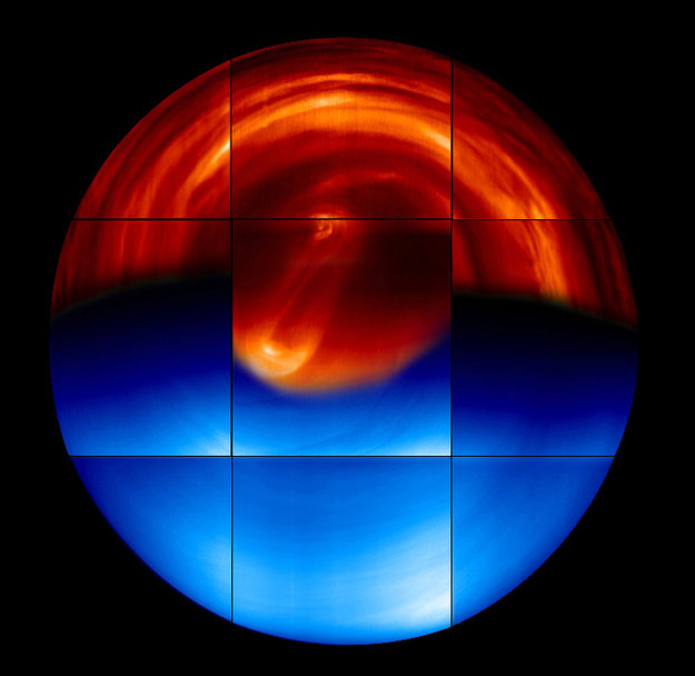
This global view of the southern hemisphere of Venus is a mosaic of images obtained by the Visible and Infrared Thermal Imaging Spectrometer (VIRTIS) on board ESA’s Venus Express on 16 May 2006.
The night-side hemisphere (in red at the top) is made of infrared images taken at 1.74 micrometres, showing the lower layers of the cloud deck surrounding the planet at about 45-km altitude.
The day-side hemisphere (in blue at the bottom) is made of ultraviolet images taken at 480 nanometres. It shows the cloud top layer at about 65-km altitude.
The red part of the central panel was taken at 3.8 micrometres, and shows the double vortex at the south pole, at an altitude of about 60 km, surrounded by a collar of ‘cold’ air.
.
After eight years in orbit, ESA’s Venus Express has completed routine science observations and is preparing for a daring plunge into the planet’s hostile atmosphere.
Venus Express was launched on a Soyuz–Fregat from the Russian Baikonur Cosmodrome in Kazakhstan on 9 November 2005, and arrived at Venus on 11 April 2006.
It has been orbiting Venus in an elliptical 24-hour loop that takes it from a distant 66 000 km over the south pole – affording incredible global views – to an altitude of around 250 km above the surface at the north pole, close to the top of the planet’s atmosphere.
With a suite of seven instruments, the spacecraft has provided a comprehensive study of the ionosphere, atmosphere and surface of Venus.
“Venus Express has taught us just how variable the planet is on all timescales and, furthermore, has given us clues as to how it might have changed since its formation 4.6 billion years ago,” says Håkan Svedhem, ESA’s project scientist.
“This information is helping us decipher how Earth and Venus came to lead such dramatically different lives, but we’ve also noticed that there are some fundamental similarities.”
Venus has a surface temperature of over 450°C, far hotter than a normal kitchen oven, and an extremely dense, choking mixture of noxious gases for an atmosphere. But from the mission’s infrared survey of the chemical composition of the rocky surface, we have learned that Venus might have once had a plate tectonics system like Earth, and even an ocean of water.
Just like Earth, Venus is losing parts of its upper atmosphere to space and Venus Express measured twice as many hydrogen atoms escaping out of the atmosphere than oxygen. Because water is made of two hydrogen atoms and one oxygen atom, the observed escape indicates that water is being broken up in the atmosphere.
Today, the total amount of water on Earth is 100 000 times that on Venus. But because the two planets are about the same size and formed at the same time, both may have had similar amounts of the precious liquid in their early years.
Meanwhile, the spacecraft’s cameras have tracked thousands of features in the cloud tops some 70 km above the planet’s surface, including an enormous swirling vortex at the planet’s south pole that shares similarities with hurricanes on Earth. The spacecraft also recorded bursts of lightning – identified by their electromagnetic signature – generated in clouds of sulphuric acid.
.
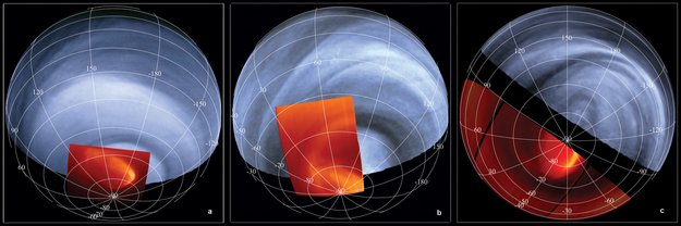
In this mosaic, infrared images taken at a wavelength of 5 micrometres (in red) are overlaid on ultraviolet images, taken at 0.365 micrometres.
The bright areas in the infrared images represent the temperatures at the cloud tops (dark regions denote lower temperatures). The oval feature that stands out in these images is the giant eye of a hurricane, or the polar vortex, at the planet’s south pole. Its centre is displaced from the south pole and the structure measures about 2000 km across, rotating around the pole in about 2.5 days. The atmosphere rotates anticlockwise in the figure.
Quelle: ESA
.
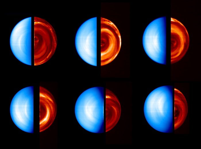
Views of Venus day and night side
This sequence of images was taken by the Ultraviolet/Visible/Near-Infrared spectrometer (VIRTIS) on board ESA’s Venus Express spacecraft between 12 and 19 April 2006, during the first orbit (capture orbit) around the planet.
The images were obtained at six different time slots and different distances from the planet (top left: 12 April, from 210 000 kilometres; top centre: 13 April, from 280 000 kilometres; top right: 14 April, from 315 000 kilometres; bottom left:16 April, from 315 000 kilometres; bottom centre: 17 April, from 270 000 kilometres; bottom right: 19 April, from 190 000 kilometres), while the spacecraft moved along a long ellipse around Venus
.
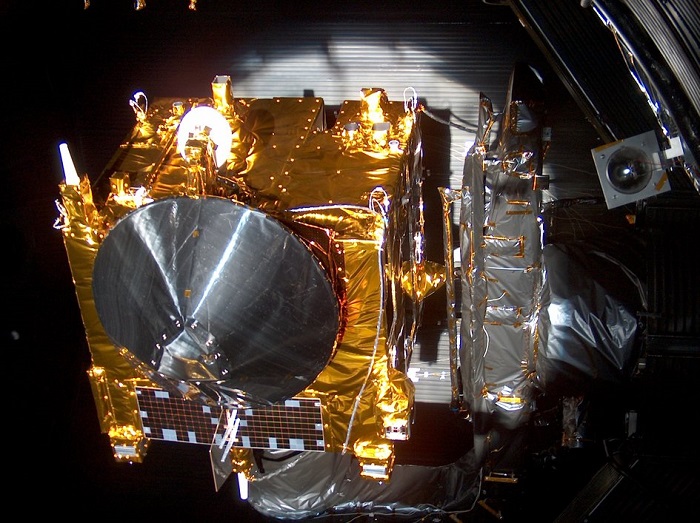
Venus Express undergoing thermal vacuum tests
Before launch – Venus Express undergoing thermal vacuum testing with simulated Sun exposure, by INTESPACE, Toulouse.
.
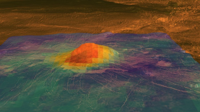
The volcanic peak Idunn Mons
This figure shows the volcanic peak Idunn Mons (at 46°S, 214.5°E) in the Imdr Regio area of Venus. The topography derives from data obtained by NASA’s Magellan spacecraft, with a vertical exageration of 30 times. Radar data (in brown) from Magellan has been draped on top of the topographic data. Bright areas are rough or have steep slopes. Dark areas are smooth.
The coloured overlay shows the heat patterns derived from surface brightness data collected by the visible and infrared thermal imaging spectrometer (VIRTIS) aboard ESA’s Venus Express spacecraft. Temperature variations due to topography were removed. The brightness signals the composition of the minerals that have been changed due to lava flow. Red-orange is the warmest area and purple is the coolest. The warmest area is situated on the summit, which stands about 2.5 km above the plains, and on the bright flows that originate there. Idunn Mons has a diameter of about 200 km.
The VIRTIS data was collected from May 2006 to the end of 2007.
Quelle: ESA
.
Update: 7.06.2014
.
Wetterbericht von Venus
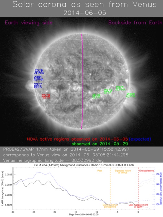
This image is part of the Venus space weather report issued 5 June 2014.
During May-August 2014, ground controllers flying ESA's Venus Express will receive daily reports on solar activity issued by experts at ESA’s Space Weather Coordination Centre (SSCC), at the Space Pole in Belgium. The weather updates will deliver the best information from a variety of sources – including ESA’s Proba-2 and solar-orbiting ESA and NASA spacecraft – to the control team as rapidly as possible.
.
For the first time, ESA is providing regular space-weather reports for a spacecraft orbiting another planet.
When your spacecraft is surfing deep into the atmosphere of an alien world, you need the latest information on conditions that could affect your trajectory.
If that planet is Venus, that means knowing what’s happening on our Sun in real time, because solar activity can greatly influence conditions like atmospheric density and the radiation environment at Earth’s closest neighbour.
Since May, ground controllers flying Venus Express have been receiving daily reports on solar activity issued by experts at ESA’s Space Weather Coordination Centre (SSCC), at the Space Pole in Belgium.
The centre was established by the Agency’s Space Situational Awareness (SSA) programme office, and it began delivering precursor space-weather services for terrestrial clients in last year.
Now that Venus Express has completed its eight-year scientific mission, the reports are especially important as the control team take the satellite through an extraordinary multi-week ‘aerobraking’ campaign.
“Aerobraking means lowering the spacecraft so that for part of each orbit it dips down very low and skims through the very uppermost reaches of the Venusian atmosphere,” notes Adam Williams, Deputy Spacecraft Operations Manager.
“We know that the current state of our Sun can affect Venus’ atmosphere, which could in turn impact the planned orbit of Venus Express as it passes through the atmosphere.”
Adam says that the team do not expect to replan any of the aerobraking orbits based on ‘typical’ solar activity levels.
“The space weather reports will, however, allow us to better understand anomalous behaviour that we may subsequently observe on the spacecraft.
“And in extreme cases, we would be more ready to react to a serious situation. For example, if our startrackers were to be overloaded by radiation.”
The weather updates will deliver the best information from a variety of sources – including ESA’s Proba-2 and solar-orbiting ESA and NASA spacecraft – to the control team as rapidly as possible.
“The aim is to report on current conditions and give a short-term forecast of solar activity and radiation conditions, tailored for Venus,” says Juha-Pekka Luntama, responsible for space weather in the SSA programme office.
“We’re used to doing this for Earth-orbiting spacecraft, but it’s quite a challenge for Venus due to both its location and the complexity of that planet’s environment.
“Venus is currently 59° ahead of Earth on its orbit around the Sun, and we do not have a spacecraft between the Sun and Venus as we have for Earth.
“So, we need to adapt and extend space weather forecasts we regularly provide towards the direction of Venus.”
The first Venus space-weather report was issued on 19 May, and included analysis and forecasts based on data not only from the fleet of solar monitors but also from a new network of Expert Service Centres on the ground operated by ESA member states in the SSA programme.
Juha-Pekka says that ESA’s network will be expanded later this year to include the Heliospheric Weather Expert Service Centre, which will provide dedicated space-weather information for missions travelling to other locations in the Solar System.
In the meantime, the SSCC will continue providing daily reports to the Venus Express team.
“We’ll also issue special bulletins during the day if there is a significant solar event that might affect the Venus space environment.
“If we’ve learned anything about forecasting space weather, it’s that there can always be surprises we were not able to predict.”
.
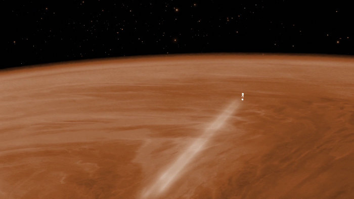
Visualisation of Venus Express during the aerobraking manoeuvre, which will see the spacecraft orbiting Venus at an altitude of around 130 km from 18 June to 11 July. In the month before, the altitude will gradually be reduced from around 200 km to 130 km. If the spacecraft survives and fuel permits, the elevation of the orbit will be raised back up to approximately 450 km, allowing operations to continue for a further few months. Eventually, however, the spacecraft will plunge back into the atmosphere and the mission will end.
.
Quelle: ESA