
6.08.2021
It will be country’s first sky eye to be placed in geo-stationary orbit
Chennai: Three days prior to the celebration of its Independence Day, India will be sending up its earth observation satellite EOS-03 earlier named or the Geo Imaging Satellite-1 (GISAT-1), said the Indian space agency.
The GISAT-1 will be the country’s first sky eye or earth observation satellite to be placed in geo-stationary orbit.
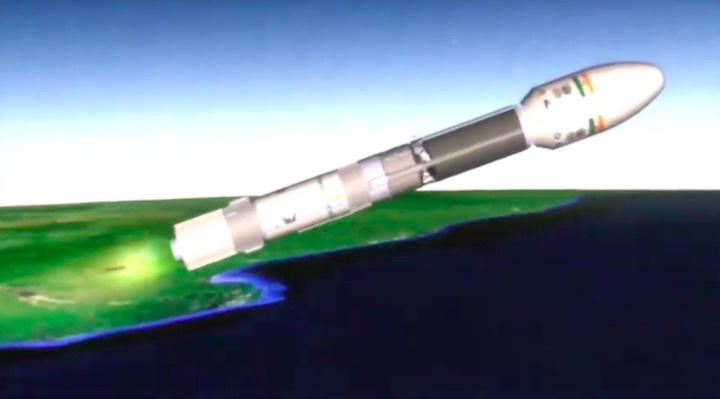
The GISAT-1 will be launched by the rocket Geosynchronous Satellite Launch Vehicle-F10 (GSLV-F10) on August 12. The rocket is expected to blast off at 5.43am on that day from the second launch pad, said Indian Space Research Organisation (ISRO).
India’s rocket port is located at Sriharikota in Andhra Pradesh.
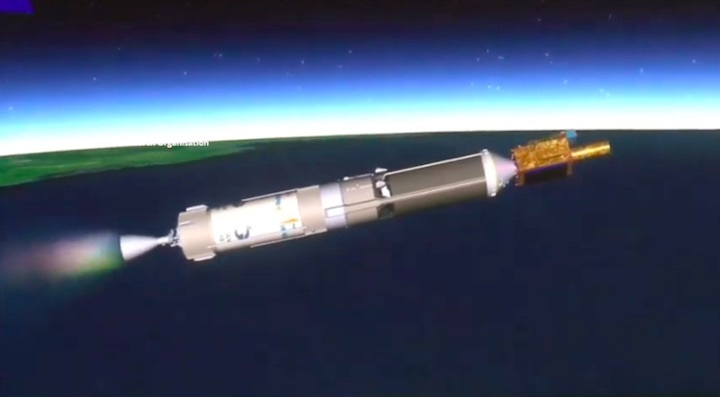
The GSLV-F10 rocket will leave the GISAT-1 at the geosynchronous transfer orbit from where the satellite will be taken up to its final position firing its onboard motors.
Once placed in geostationary orbit, the satellite will have a steady eye on the areas of interest (the satellite will move in sync with the rotation of the earth and hence would look stationary) unlike other remote sensing satellites placed in lower orbit that can come to a spot only at regular intervals.
Originally the GISAT-1 was slated for launch on March 5, 2020, but hours before the launch ISRO announced postponement of the mission owing to some technical glitch.
Soon after the Covid-19 pandemic and the lockdown delayed the mission. The rocket had to be dismantled and cleaned up.
Subsequently, the GISAT-1 launch was slated for March 2021 but due to problems in the satellite’s battery side, the flight got delayed.
With the replacement of the battery the satellite and the rocket were being readied for their flight at Sriharikota when the second wave of COVID-19 swept in affecting many at the rocket launch centre.
Strategic role in the nation’s defence
The Indian space agency had earlier said the 2,268kg GISAT-1 would provide a real time image of a large area of region of interest at frequent intervals. It will also enable quick monitoring of natural disasters, episodic events and any short-term events.
The satellite will have payload imaging sensors of six band multi-spectral visible and near infra-red with 42 metres resolution; 158 bands hyper-spectral visible and near infra-red with 318 metres resolution and 256 bands hyper-spectral short wave infra-red with 191 metres resolution.
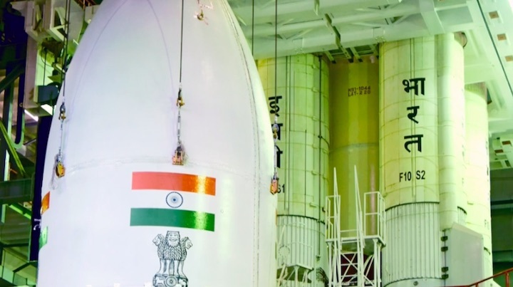
A four metre diameter Ogive shaped payload fairing (heat shield) has been used in the rocket for the first time, ISRO had said.
According to ISRO, after GISAT-1 launch, the other satellite to go up will be EOS-4 or Risat-1A is a radar imaging satellite with Synthetic Aperture Radar (SAR) that can take pictures during day and night looking through the clouds.
The satellite weighing over 1,800 kg will be carried by the Polar Satellite Launch Vehicle (PSLV) this September, said ISRO.
The EOS-4 is a repeat microwave remote sensing satellite of Risat-1 and is configured to ensure continuity of SAR in C-Band providing microwave data to the user community for operational services.
The satellite will play a strategic role in the nation’s defence with its capability to operate in day, night and all weather conditions with a mission life of five years.
The satellite has high data handling systems and high storage devices among other things.
According to ISRO, the satellite will provide imaging data for various applications related to land, water and environment which find useful inputs for agriculture, forestry and water resource management, said ISRO.
An ISRO official had earlier said an earth observation satellite will send pictures which will be used by different agencies as per their needs.
The Risat-1 weighing 1,858 kg was launched in 2012 using a PSLV rocket. Its mission life was five years.
Quelle: Gulf News
----
Update: 9.08.2021
.
EXPLAINED: India In Real-Time And Hi-Res. How Isro's Gisat-1 Will Be A 'Game-Changer'
Indian space scientists are set to add another feather to their caps with the launch of the country’s first state-of-the-art agile Earth Observation Satellite (EOS) on August 12. Perched in an orbit high above the Earth, this “eye in the sky" will allow real-time monitoring of the entire subcontinent, helping with everything from agriculture to defence.
WHAT IS GISAT-1?
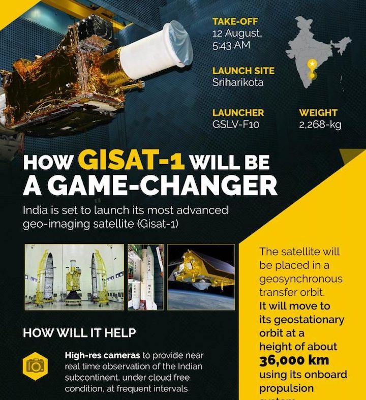
Developed by the Indian Space Research Organisation (ISRO), Gisat is an imaging satellite that will be launched via the indigenously made Geosynchronous Satellite Launch Vehicle-F10 (GSLV-F10) from the Satish Dhawan Space Centre at Sriharikota in Andhra Pradesh. The tentative take-off is at 5.43 am on August 12, 2021, weather permitting.
The satellite weighs more than 2 tonnes and ISRO will for the first time be using an Ogive-shaped fairing — basically, a classic bullet-shaped pointed curved surface casing — with the view to accommodating a larger payload.
The satellite will be placed by GSLV-F10 in a geosynchronous transfer orbit following which it will climb to its geostationary orbit at a height of about 36,000 km above the Earth’s surface using its onboard propulsion system.
WHAT ARE THE ADVANTAGES OF A GEOSTATIONARY SATELLITE?
Geostationary implies that the satellite will be located above the Equator and always appear to be fixed at one point in the sky. But such satellites aren’t motionless. All that happens is that the high orbit they are placed in “makes the satellite travel at the same rate as the Earth’s spin“. With its movement thus synchronised with the rotation of the Earth, Gisat-1 will be circling the Earth once every 24 hours.
How such satellites help on-ground receiving stations is that they can be pointed to a fixed location in the sky and don’t have to constantly readjust — which would be the case with low-Earth satellites, which need to be tracked across the sky.
ISRO says that India now “has one of the largest constellations of remote sensing satellites" for Earth observation with data from these satellites used for “several applications covering agriculture, water resources, urban planning, rural development, mineral prospecting, environment, forestry, ocean resources and disaster management".
HOW WILL GISAT-1 HELP?
Reports say that the advanced imaging satellite has been described as a “game changer" for India with its high resolution cameras allowing constant, real-time monitoring of the Indian landmass and the oceans. Among the key areas where it can prove its utility is defence, enabling “special attention to the country’s borders for security reasons".
Further, when it comes to natural disasters, monitoring by the satellite can ensure that precautions are taken well in advance to reduce their impact. Apart from disaster warning, ISRO said the satellite will also provide “spectral signatures for agriculture, forestry, mineralogy, cloud properties, snow and glaciers and oceanography" and will be carrying multispectral and hyperspectral cameras in different bands “with improved spatial and temporal resolution".
However, the satellite needs cloud-free conditions to capture images. Union minister Jitendra Singh has told Rajya Sabha that the satellite can accomplish imaging of the whole country 4-5 times daily.
WHY WAS ITS LAUNCH DELAYED?
From technical glitches to the Covid-19 pandemic, the Gisat-1 launch has had to suffer multiple delays and will be only the second launch by ISRO so far in 2021 following the February launch of 18 small satellites.
It was originally slated for launched on March 5, 2020, but that was cancelled due to technical reasons. Right after followed the pandemic and the lockdowns it brought along with it, which meant the the Gisat-1 launch suffered a lengthy delay. Rescheduled for March 28 this year, “a minor issue" first led the launch to be put off till April and, then, as the second wave broke, to May.
Quelle: NEWS18
+++
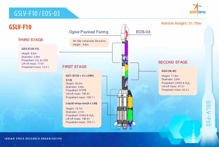
GSLV-F10 / EOS-03

GSLV-F10 is scheduled to launch EOS-03 on August 12, 2021 from Satish Dhawan Space Centre SHAR
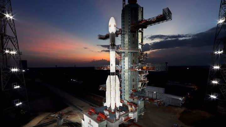
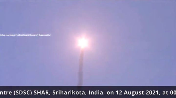
Geosynchronous Satellite Launch Vehicle-F10 (GSLV-F10) will launch Earth Observation Satellite, EOS-03 from the Second Launch Pad of Satish Dhawan Space Centre (SDSC) SHAR, Sriharikota. The launch is tentatively scheduled at 0543 Hrs IST on August 12, 2021, subject to weather conditions.
EOS-03 is a state-of-the-art agile Earth observation satellite which will be placed in a Geosynchronous Transfer Orbit by GSLV-F10. Subsequently, the satellite will reach the final geostationary orbit using its onboard propulsion system.
A 4 metre diameter Ogive shaped payload fairing is being flown for the first time in this GSLV flight. This is the fourteenth flight of GSLV.
+++

Quelle: ISRO
----
Update: 12.08.2021
.
Countdown begins for ISRO's launch of GISAT-1 EOS-03 satellite
ISRO began countdown for the launch of its Geosynchronous Satellite Launch Vehicle-F10 rocket carrying India's first earth observation satellite, EOS-03.
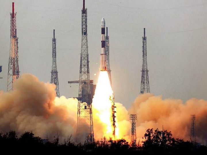
New Delhi: The Indian space agency early morning on Wednesday began the countdown for the launch of its Geosynchronous Satellite Launch Vehicle-F10 rocket carrying the country`s first Geo Imaging Satellite-1 (GISAT-1) earth observation satellite, EOS-03.
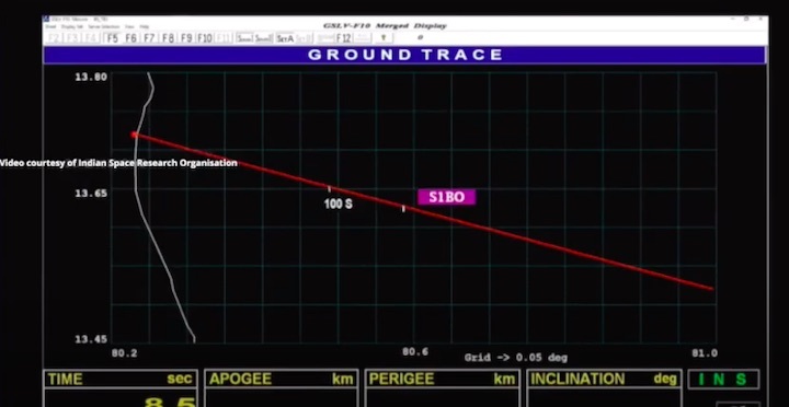
The 51.70 metre tall weighing 416 ton Geosynchronous Satellite Launch Vehicle-F10 (GSLV-F10) is scheduled to blast off from the second launch pad at the Sriharikota rocket port in Andhra Pradesh on Thursday at 5.43 am. The rocket will be carrying the 2,268 kg and just over 18 minutes into its flight, the satellite will be placed at the geosynchronous transfer orbit (GTO).
The India Space Research Organisation (ISRO) said the satellite will be taken up to its final position firing its onboard motors.
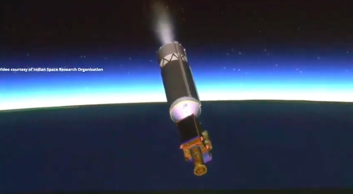
The GSLV is a three stage/engine rocket. The core of the first stage is fired with solid fuel and the four strap-on motors by liquid fuel. The second is the liquid fuel and the third is the cryogenic engine.
Quelle: ZEE NEWS
+++
India GSLV-F10 fails to launch EOS-03
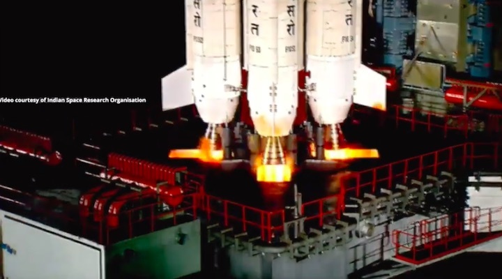
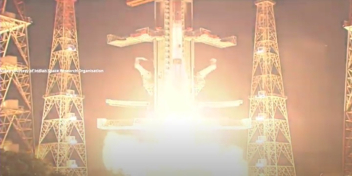

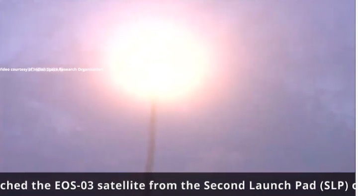
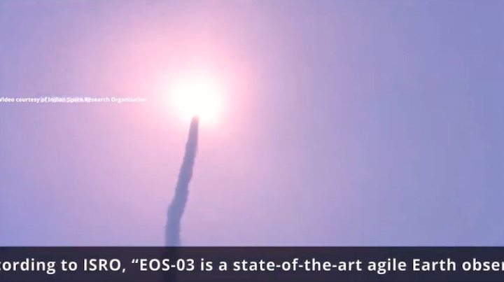
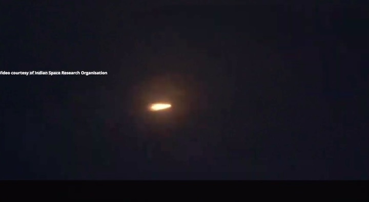
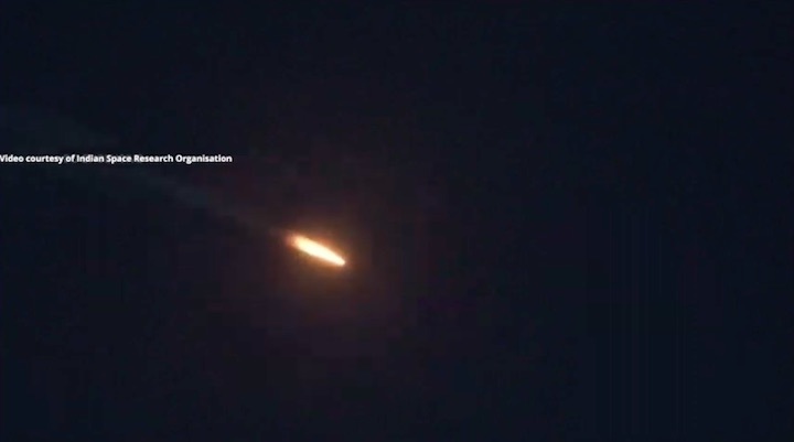
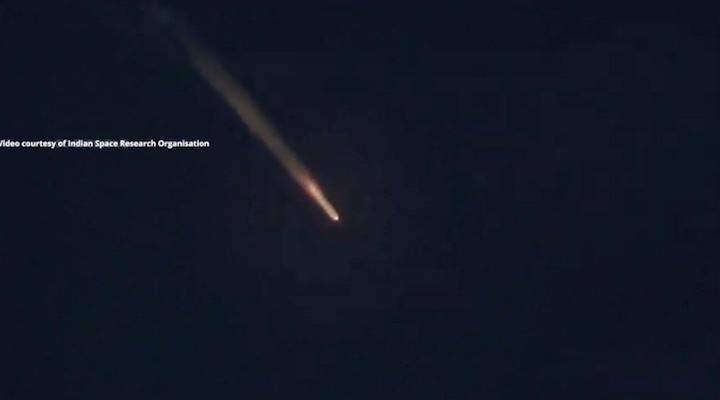
A Geosynchronous Satellite Launch Vehicle Mk II (GSLV-F10) launched the EOS-03 satellite from the Second Launch Pad (SLP) of the Satish Dhawan Space Centre (SDSC) SHAR, Sriharikota, India, on 12 August 2021, at 00:13 UTC (05:43 IST). The satellite was not placed into the desired orbit due to a problem with the third cryogenic stage. According to ISRO, “EOS-03 is a state-of-the-art agile Earth observation satellite”. The GSLV-F10 mission was the fourteenth flight of ISRO’s Geosynchronous Satellite Launch Vehicle (GSLV). Credit: Indian Space Research Organisation (ISRO) ISRO GSLV-F10 mission GSLV Mk II launches EOS-03
Quelle: ISRO
----
Update: 14.08.2021
.
Cryogenic engine fails, ISRO loses hi-tech satellite
The satellite was meant to give advance info on weather conditions, agriculture, forestry, natural disasters and water bodies.
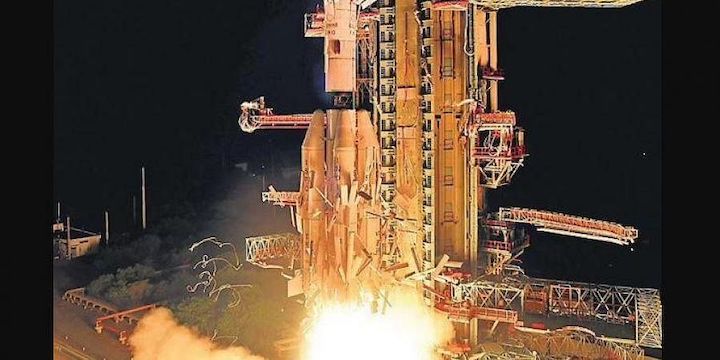
The ill-fated GSLV-F10 blasts off from Sriharikota spaceport on Thursday | PT
BENGALURU: At a time when the country is witnessing a spurt in natural disasters, the Indian Space Research Organisation (ISRO) on Thursday failed to put its state-of-the-art Earth observation satellite into orbit. The satellite was meant to give advance info on weather conditions, agriculture, forestry, natural disasters and water bodies.
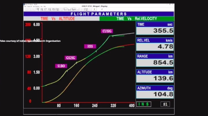
The Geostationary Satellite Launch Vehicle rocket took off at 5.43 am and accomplished the separation of the first two stages but the crucial cryogenic stage failed to release the satellite in its intended geosynchronous transfer orbit.
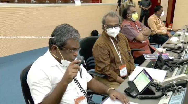
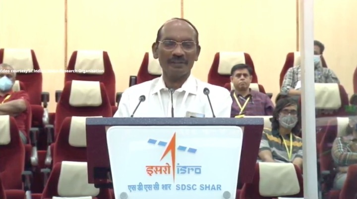
“The cryogenic upper stage ignition did not happen due to technical anomaly. The mission couldn’t be accomplished as intended,” ISRO Chairman K Sivan said. The rocket’s third stage carried a four-metre diameter Ogive payload fairing, encasing the EOS-03 satellite.
Union Minister Jitendra Singh, who held a detailed discussion with Sivan, said the mission can be rescheduled. The EOS-03 is the first state-of-the-art agile Earth observation satellite planned to be put in geostationary orbit to provide near real-time imaging of large regions of interest at frequent intervals, and was to serve in quick monitoring of natural disasters, episodic events and any short-term events. It was also equipped to obtain spectral signatures for agriculture, water bodies as well as for cloud burst/thunderstorm monitoring, etc.
Madhavan Nair shocked over cryogenic engine failure
Former IS RO chairman G Madhavan Nair, who expressed shock over the failure, said ISRO’s cryogenic engine track record was much better than Russia and the European countries which recorded a failure rate of about 20 per cent. He, however, expressed confidence that a “resilient ISRO” will bounce back. A senior ISRO scientist informed TNIE: “We have lost the mission.
However, it is not confirmed to be an ignition failure — as one cannot say ignition happened at all — it’s a little tricky. The team is yet to understand why and how it (the cryogenic stage failure) happened. However, the fact remains that the cryogenic stage did not function and that is very clear. If it had functioned as it should have, then the satellite would have been in orbit.
There must have been some problem at the ignition stage.” He said space scientists cannot speculate on the reasons for the failure of the cryogenic engine, the indigenous development and testing of which was lauded among space agencies. “The team at Sriharikota stayed up all night for the 5:43 am launch. The failure has made them very upset.
They want to have some cool-off time and start looking at data later,” the senior scientist said, requesting anonymity. “The problem obviously is not simple, but deciphering the mission failure depends on studying enormous data,” he added. The ISRO scientists now plan to analyse the videos and the telemetry and tracking data.
Quelle: THE NEW INDIAN EXPRESS