-14.12.2012
Twin NASA probes orbiting Earth's moon have generated the highest resolution gravity field map of any celestial body.
The new map, created by the Gravity Recovery and Interior Laboratory (GRAIL) mission, is allowing scientists to learn about the moon's internal structure and composition in unprecedented detail. Data from the two washing machine-sized spacecraft also will provide a better understanding of how Earth and other rocky planets in the solar system formed and evolved.
The gravity field map reveals an abundance of features never before seen in detail, such as tectonic structures, volcanic landforms, basin rings, crater central peaks and numerous simple, bowl-shaped craters. Data also show the moon's gravity field is unlike that of any terrestrial planet in our solar system.
These are the first scientific results from the prime phase of the mission, and they are published in three papers in the journal Science.
"What this map tells us is that more than any other celestial body we know of, the moon wears its gravity field on its sleeve," said GRAIL Principal Investigator Maria Zuber of the Massachusetts Institute of Technology in Cambridge. "When we see a notable change in the gravity field, we can sync up this change with surface topography features such as craters, rilles or mountains."
According to Zuber, the moon's gravity field preserves the record of impact bombardment that characterized all terrestrial planetary bodies and reveals evidence for fracturing of the interior extending to the deep crust and possibly the mantle. This impact record is preserved, and now precisely measured, on the moon.
The probes revealed the bulk density of the moon's highland crust is substantially lower than generally assumed. This low-bulk crustal density agrees well with data obtained during the final Apollo lunar missions in the early 1970s, indicating that local samples returned by astronauts are indicative of global processes.
"With our new crustal bulk density determination, we find that the average thickness of the moon's crust is between 21 and 27 miles (34 and 43 kilometers), which is about 6 to 12 miles (10 to 20 kilometers) thinner than previously thought," said Mark Wieczorek, GRAIL co-investigator at the Institut de Physique du Globe de Paris. "With this crustal thickness, the bulk composition of the moon is similar to that of Earth. This supports models where the moon is derived from Earth materials that were ejected during a giant impact event early in solar system history."
The map was created by the spacecraft transmitting radio signals to define precisely the distance between them as they orbit the moon in formation. As they fly over areas of greater and lesser gravity caused by visible features, such as mountains and craters, and masses hidden beneath the lunar surface, the distance between the two spacecraft will change slightly.
"We used gradients of the gravity field in order to highlight smaller and narrower structures than could be seen in previous datasets," said Jeff Andrews-Hanna, a GRAIL guest scientist with the Colorado School of Mines in Golden. "This data revealed a population of long, linear gravity anomalies, with lengths of hundreds of kilometers, crisscrossing the surface. These linear gravity anomalies indicate the presence of dikes, or long, thin, vertical bodies of solidified magma in the subsurface. The dikes are among the oldest features on the moon, and understanding them will tell us about its early history."
While results from the primary science mission are just beginning to be released, the collection of gravity science by the lunar twins continues. GRAIL's extended mission science phase began Aug. 30 and will conclude Dec. 17. As the end of mission nears, the spacecraft will operate at lower orbital altitudes above the moon.
When launched in September 2011, the probes were named GRAIL A and B. They were renamed Ebb and Flow in January by elementary students in Bozeman, Mont., in a nationwide contest. Ebb and Flow were placed in a near-polar, near-circular orbit at an altitude of approximately 34 miles (55 kilometers) on Dec. 31, 2011, and Jan. 1, 2012, respectively.
-
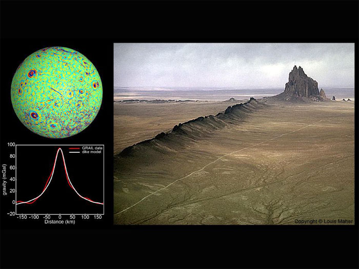
GRAIL Identifies Moon Dikes
A profile across one of the linear gravity anomalies found by NASA's GRAIL mission shows that it has higher gravity than the surroundings (the anomaly is the red line in graph at bottom left; its location is shown as a blue line in the center of the GRAIL gravity gradient map at top left). Models show that this gravity pattern indicates the presence of giant dikes beneath the surface of the moon (white line in graph at bottom left). A dike is a solidified magma filled crack that forms beneath the surface.
Dikes on Earth are sometimes exposed by erosion so that they are visible on the surface, as seen at Ship Rock, New Mexico, pictured here at right. The lunar dikes identified by GRAIL are 50 times longer and 1,000 times wider than the dike seen here.
Image credits, Left: NASA/JPL-Caltech/CSM, Right: Photo Copyright © Louis Maher
-
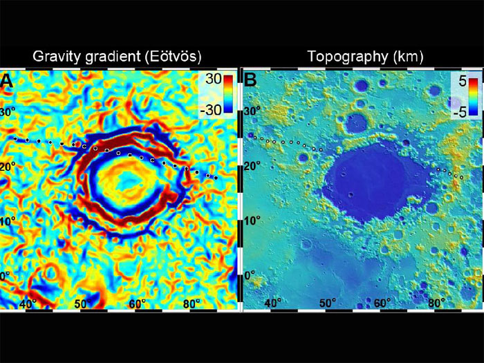
Gravity Anomaly Intersects Moon Basin
A linear gravity anomaly intersecting the Crisium basin on the nearside of the moon has been revealed by NASA's GRAIL mission. The GRAIL gravity gradient data are shown at left, with the location of the anomaly indicated. Red and blue correspond to stronger gravity gradients. Topography data over the same region from NASA's Lunar Reconnaissance Orbiter's Lunar Orbiter Laser Altimeter are shown at right; these data show no sign of the gravity anomaly.
The anomaly is truncated by the basin, indicating that it is older than the basin and was partially destroyed by the impact.
The units of the gravity gradients are Eötvös, and of the topography are kilometers.
-
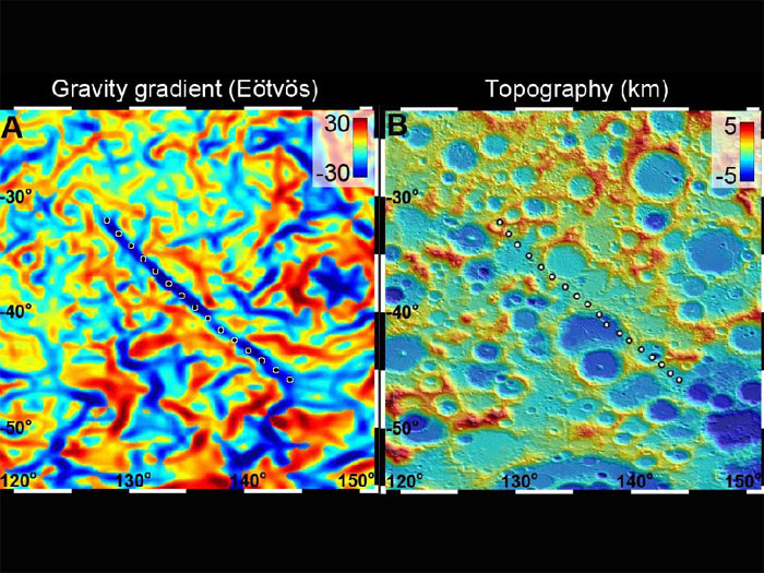
GRAIL Spots Gravity Anomaly
A 300-mile-long (500 kilometer-long) linear gravity anomaly on the far side of the moon has been revealed by gravity gradients measured by NASA's GRAIL mission. GRAIL data are shown on the left, with red and blue corresponding to stronger gravity gradients. Topography data from NASA's Lunar Reconnaissance Orbiter's Lunar Orbiter Laser Altimeter for the same region show a surface saturated with craters (red is higher terrain and blue is lower). The lack of any topographic signature over the gravity anomaly indicates that it is older than the craters, and thus is one of the oldest features on the moon.
The units of the gravity gradients are Eötvös, and of the topography are kilometers.
-
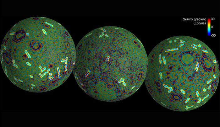
Linear Gravity Anomalies
These maps of the near and far side of the moon show the gravity gradients as measured by NASA's GRAIL mission, highlighting a population of linear gravity anomalies. The linear gravity anomalies are long blue streaks in the gradient maps. At least 22 anomalies with a combined length of more than 3,000 miles (4,800 kilometers) have been identified, with individual features having lengths up to and exceeding 300 miles (500 kilometers).
-
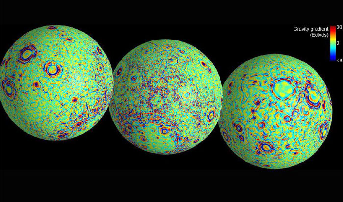
GRAIL's Gravity Gradients
These maps of the near and far side of the moon show gravity gradients as measured by NASA's GRAIL mission.
Red and blue areas indicate stronger gradients due to underlying mass anomalies.
-
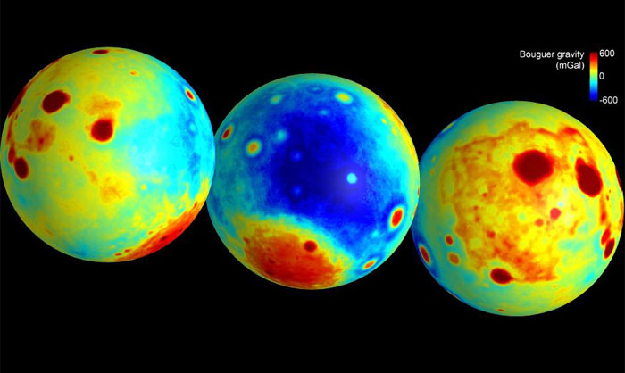
Gravity of the Moon's Crust
These maps of the moon show the "Bouguer" gravity anomalies as measured by NASA's GRAIL mission. Bouguer gravity is what remains from the gravity field when the attraction of surface topography is removed, and therefore represents mass anomalies inside the moon due to either variations in crustal thickness or crust or mantle density.
Red areas have stronger gravity, while blue areas have weaker gravity.
-
Quelle: NASA
-
Update: 12.12.2012
NASA's twin Grail spacecraft will crash into the lunar surface intentionally next week, bringing their gravity-mapping mission to a spectacular end.
The probes, known as Ebb and Flow, will be commanded to slam into the moon on Dec. 17, NASA officials said Monday (Dec. 10). The agency will host a press conference Thursday (Dec. 13) at 1:30 p.m. EST (1830 GMT) to discuss the impact and the events leading up to it.
The $496 million Grail mission — short for Gravity Recovery and Interior Laboratory — launched in September 2011 to map the moon's gravity field in unprecedented detail. Ebb and Flow arrived in orbit around the moon about one year ago — on New Year's Eve and New Year's Day, respectively.-
-
Update: 14.12.2012
Twin NASA Probes Prepare for Dec. 17 Mission-Ending Moon Impact
PASADENA, Calif. -- Twin lunar-orbiting NASA spacecraft that have allowed scientists to learn more about the internal structure and composition of the moon are being prepared for their controlled descent and impact on a mountain near the moon's north pole at about 2:28 p.m. PST (5:28 p.m. EST) Monday, Dec. 17.
Ebb and Flow, the Gravity Recovery and Interior Laboratory (GRAIL) mission probes, are being sent purposely into the lunar surface because their low orbit and low fuel levels preclude further scientific operations. The duo's successful prime and extended science missions generated the highest resolution gravity field map of any celestial body. The map will provide a better understanding of how Earth and other rocky planets in the solar system formed and evolved.
"It is going to be difficult to say goodbye," said GRAIL principal investigator Maria Zuber of the Massachusetts Institute of Technology in Cambridge. "Our little robotic twins have been exemplary members of the GRAIL family, and planetary science has advanced in a major way because of their contributions."
The mountain where the two spacecraft will make contact is located near a crater named Goldschmidt. Both spacecraft have been flying in formation around the moon since Jan. 1, 2012. They were named by elementary school students in Bozeman, Mont., who won a contest. The first probe to reach the moon, Ebb, also will be the first to go down, at 2:28:40 p.m. Flow will follow Ebb about 20 seconds later.
Both spacecraft will hit the surface at 3,760 mph (1.7 kilometers per second). No imagery of the impact is expected because the region will be in shadow at the time.
Ebb and Flow will conduct one final experiment before their mission ends. They will fire their main engines until their propellant tanks are empty to determine precisely the amount of fuel remaining in their tanks. This will help NASA engineers validate fuel consumption computer models to improve predictions of fuel needs for future missions.
"Our lunar twins may be in the twilight of their operational lives, but one thing is for sure, they are going down swinging," said GRAIL project manager David Lehman of NASA's Jet Propulsion Laboratory in Pasadena, Calif. "Even during the last half of their last orbit, we are going to do an engineering experiment that could help future missions operate more efficiently."
Because the exact amount of fuel remaining aboard each spacecraft is unknown, mission navigators and engineers designed the depletion burn to allow the probes to descend gradually for several hours and skim the surface of the moon until the elevated terrain of the target mountain gets in their way.
The burn that will change the spacecrafts' orbit and ensure the impact is scheduled to take place Friday morning.
"Such a unique end-of-mission scenario requires extensive and detailed mission planning and navigation," said Lehman. "We've had our share of challenges during this mission and always come through in flying colors, but nobody I know around here has ever flown into a moon mountain before. It'll be a first for us, that's for sure."
During their prime mission, from March through May, Ebb and Flow collected data while orbiting at an average altitude of 34 miles (55 kilometers). Their altitude was lowered to 14 miles (23 kilometers) for their extended mission, which began Aug. 30 and sometimes placed them within a few miles of the moon's tallest surface features.
JPL manages the GRAIL mission for NASA's Science Mission Directorate in Washington. The mission is part of the Discovery Program managed at NASA's Marshall Space Flight Center in Huntsville, Ala. Lockheed Martin Space Systems in Denver built the spacecraft.
-
Update: 17.12.2012
-
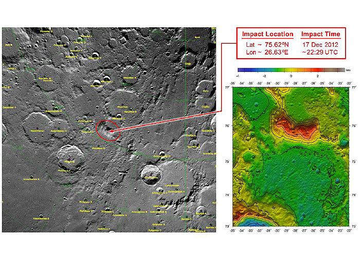
GRAIL's Final Resting Spot
These maps of Earth's moon highlight the region where the twin spacecraft of NASA's Gravity Recovery and Interior Laboratory (GRAIL) mission will impact on Dec. 17, marking the end of its successful endeavor to map the moon's gravity. The two washing-machine-sized spacecraft, named Ebb and Flow, will impact at an unnamed mountain near the moon's North Pole.
These maps are from NASA's Lunar Reconnaissance Orbiter.
-
PASADENA, Calif. -- Twin lunar-orbiting NASA spacecraft that have allowed scientists to learn more about the internal structure and composition of the moon are being prepared for their controlled descent and impact on a mountain near the moon's north pole at about 2:28 p.m. PST (5:28 p.m. EST) Monday, Dec. 17.
Ebb and Flow, the Gravity Recovery and Interior Laboratory (GRAIL) mission probes, are being sent purposely into the lunar surface because their low orbit and low fuel levels preclude further scientific operations. The duo's successful prime and extended science missions generated the highest-resolution gravity field map of any celestial body. The map will provide a better understanding of how Earth and other rocky planets in the solar system formed and evolved.
"It is going to be difficult to say goodbye," said GRAIL principal investigator Maria Zuber of the Massachusetts Institute of Technology in Cambridge. "Our little robotic twins have been exemplary members of the GRAIL family, and planetary science has advanced in a major way because of their contributions."
The mountain where the two spacecraft will make contact is located near a crater named Goldschmidt. Both spacecraft have been flying in formation around the moon since Jan. 1, 2012. They were named by elementary school students in Bozeman, Mont., who won a contest. The first probe to reach the moon, Ebb, also will be the first to go down, at 2:28:40 p.m. PST. Flow will follow Ebb about 20 seconds later.
Both spacecraft will hit the surface at 3,760 mph (1.7 kilometers per second). No imagery of the impact is expected because the region will be in shadow at the time.
Ebb and Flow will conduct one final experiment before their mission ends. They will fire their main engines until their propellant tanks are empty to determine precisely the amount of fuel remaining in their tanks. This will help NASA engineers validate fuel consumption computer models to improve predictions of fuel needs for future missions.
"Our lunar twins may be in the twilight of their operational lives, but one thing is for sure, they are going down swinging," said GRAIL project manager David Lehman of NASA's Jet Propulsion Laboratory in Pasadena, Calif. "Even during the last half of their last orbit, we are going to do an engineering experiment that could help future missions operate more efficiently."
Because the exact amount of fuel remaining aboard each spacecraft is unknown, mission navigators and engineers designed the depletion burn to allow the probes to descend gradually for several hours and skim the surface of the moon until the elevated terrain of the target mountain gets in their way.
The burn that will change the spacecrafts' orbit and ensure the impact is scheduled to take place Friday morning, Dec. 14.
"Such a unique end-of-mission scenario requires extensive and detailed mission planning and navigation," said Lehman. "We've had our share of challenges during this mission and always come through in flying colors, but nobody I know around here has ever flown into a moon mountain before. It'll be a first for us, that's for sure."
During their prime mission, from March through May, Ebb and Flow collected data while orbiting at an average altitude of 34 miles (55 kilometers). Their altitude was lowered to 14 miles (23 kilometers) for their extended mission, which began Aug. 30 and sometimes placed them within a few miles of the moon's tallest surface features.
-
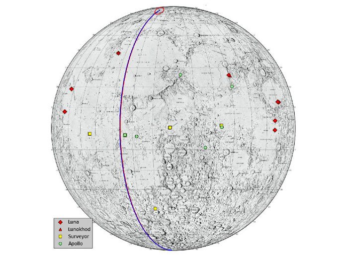
Lunar Heritage Sites and GRAIL's Final Mile
This graphic highlights locations on the moon NASA considers "lunar heritage sites" and the path NASA's Gravity Recovery and Interior Laboratory spacecraft will take on their final flight. Navigators on the GRAIL team have designed an end of mission plan that rules out the extremely remote possibility of either of the two GRAIL spacecraft impacting near any of these historic locations. The Apollo 11, 12, 14, 16 and 17 landing sites are indicated with green circles. The Surveyor sites are indicated with yellow squares. The Soviet Union's Luna and Lunakhod landing sites are indicated with red diamonds and red squares, respectively.
The ground track for the Ebb and Flow spacecraft during their final half-orbits is shown in black. The maps are color-coded by topography. Red and white indicate the high areas. Blue and violet indicate low areas.
-
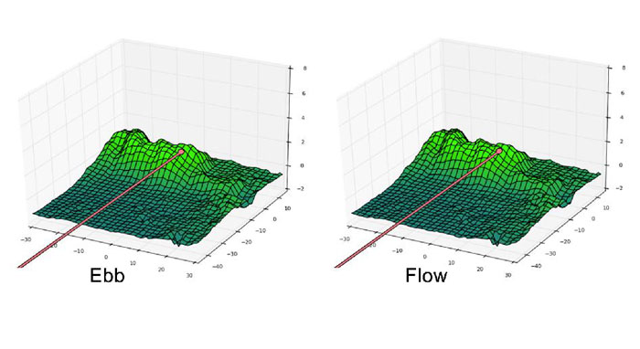
Ebb and Flow's Final Moments
These side-by-side, 3-D comparisons depict the unnamed lunar mountain targeted by the NASA's Gravity Recovery and Interior Laboratory (GRAIL) mission for controlled impact of the Ebb and Flow spacecraft. They also include the ground tracks the spacecraft are expected to follow into the lunar terrain. These graphics were generated using data from the Lunar Orbiter Laser Altimeter instrument aboard NASA's Lunar Reconnaissance Orbiter spacecraft.
On the left is the mountain with the ground track and mission termination point for the Ebb spacecraft. On the right is the mountain, ground track and mission termination point for the Flow spacecraft.
-
Quelle: NASA
-
Update: 18.12.2012
Die Zwillingssonden "Ebb" und "Flow" (Ebbe und Flut) der US-Raumfahrtbehörde NASA sind am späten Montagabend planmäßig über dem Mond abgestürzt. Die knapp waschmaschinengroßen Sonden hatten fast ein Jahr lang den Erdtrabanten erkundet. Die Roboter-Zwillinge waren für ein letztes Experiment nochmals auf Vollgas geschaltet worden, um den restlichen Treibstoff in ihren Tanks zu verbrennen.
"Ebb" und "Flow" trafen mit einer Geschwindigkeit von etwa 1,7 Kilometern pro Sekunde kurz hinter einander auf einen kleinen Berg des Mondes nahe dem Goldschmidt-Krater.
6065 Views
