
.
After completing an eventful year, ISRO is gearing up for some satellite launches this year, with the IRNSS 1D being the first, which would put in place India's own navigation system on par with the Global Positioning System of the US.
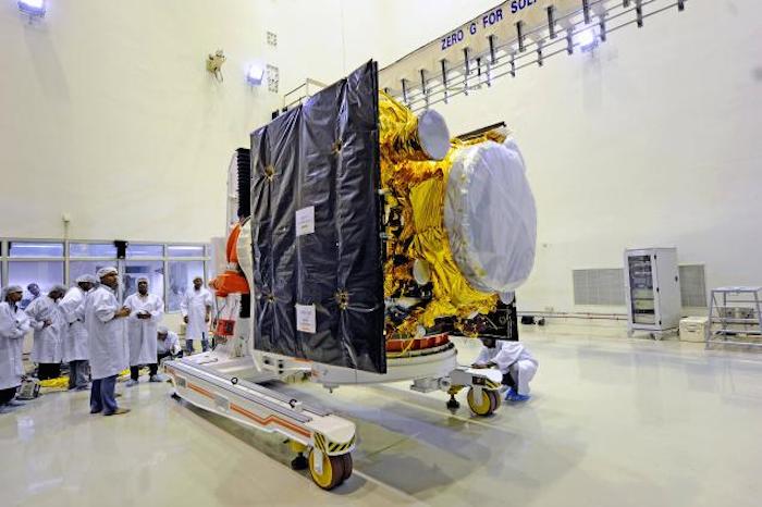
"The launch campaign for IRNSS 1D has come, which starts on January 16. Within two months, all components from other ISRO labs have to reach Sriharikota. The launch is likely after March 15," a senior ISRO official told PTI.
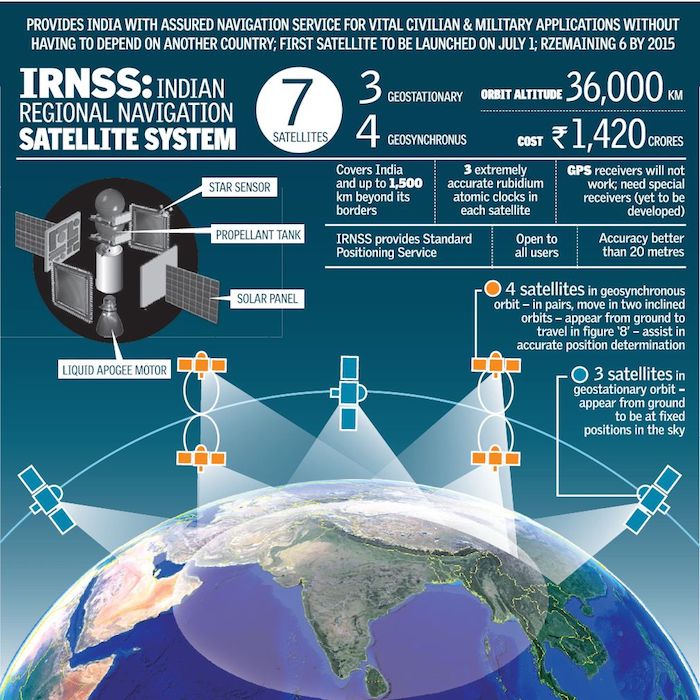
IRNSS 1D is the fourth in the series of seven satellites, the national space agency is planning to launch to put in place the Indian Regional Navigation Satellite System (IRNSS). While four satellites would be sufficient to start operations of the system, the remaining three satellites would make it more accurate and efficient.
The other launches also relate to the IRNSS series with the IRNSS1E and IRNSS1-F satellites to be launched before the year end, he said.
The first three satellites in the IRNSS series were launched from Sriharikota on July 1, 2013, April 4 and October 16 last year respectively.
The fully deployed IRNSS would consist of three and four satellites in GEO stationary and in inclined geosynchronous orbits respectively, about 36,000 km above the Earth.
The system would provide two types of services -- Standard Positioning Service, which is provided to all the users and Restricted Service, which is an encrypted service provided only to the authorised users.
The IRNSS system was targeted to be completed by this year at a total cost of Rs 1420 crore.
IRNSS is designed to provide accurate position information service to users in the country as well as the region extending up to 1,500 km from its boundary, which is its primary service area.
A select group of countries have their own navigation systems --Russia's Global Orbiting Navigation Satellite System (GLONASS), United States' Global Positioning System (GPS), European Union's Galileo (GNSS), China's BeiDou satellite navigation system and the Quasi-Zenith Satellite System.
ISRO not only launched a GLSV rocket, a GSLV Mk III, besides two PSLVs during 2014 but also successfully inserted its Mars orbiter into the Martian atmosphere and tested the re-entry of unmanned crew module from space.
Quelle: Outlook
.
ISRO to launch new satellite IRNSS 1D

ISRO will be launching a new satellite in space that will facilitate a GPS like navigation system centred towards India's needs. The satellite IRNSS 1D will be launched sometime in the first half of March this year. This mission will be the fourth satellite sent off as a part of an ongoing plan to create a navigation system for India.
IRNSS 1A, IRNSS 1B and IRNSS 1C were sent off in July 2013, April 2014 and October 2014, respectively. IRNSS 1D will be the fourth one to be launched into space and will finally inaugurate the IRNSS (Indian Regional Navigation Satellite System).
The entire navigational system will only be complete with a total of seven such satellites functioning simultaneously. Two more named according to the series IRNSS 1E and IRNSS 1F are expected to be launched into the orbit before 2015 is over.
According to the ISRO's plan to establish the navigation system, four satellites are meant to be inclined in geosynchronous orbit and three in geostationary orbit, all about 36000km above the Earth. The components of IRNSS 1D will start making their way to the allocated position at Sriharikota starting from January 16.
The US has its NAVSTAR Global Positioning System (GPS) which was initially launched by US for military purpose but was allowed to the general public in its full capability only from 2000, Russia is behind the Global Orbiting Navigation Satellite System (GLONASS) and China uses two similar systems of its own. India will soon be joining the list with its IRNSS satellite after the successful positioning of all seven satellites.
This navigational system will permit exclusive location based services for India. Services like live and accurate directions for drivers, providing visuals of India's geographic expanse, manoeuvre devices using the location signals, disaster management and all the common services that are provided by the current GPS system that are commonly used, but with greater accuracy. The total cost of this space program is estimated around Rs 1420 crores.
Quelle: indiatoday
.
4724 Views