
.
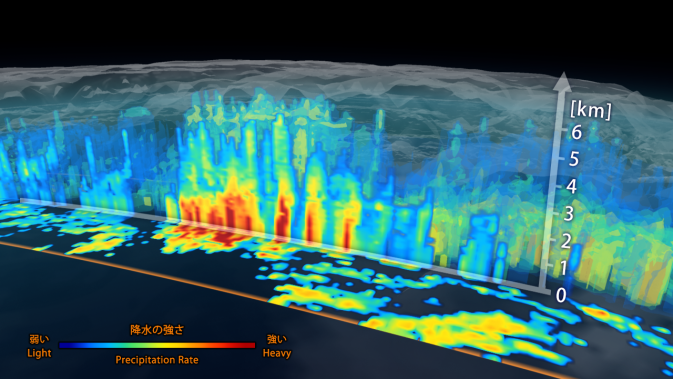
3D view inside an extra-tropical cyclone observed off the coast of Japan, March 10, 2014, by GPM's Dual-frequency Precipitation Radar. The vertical cross-section approx. 4.4 mi (7 km) high show rain rates: red areas indicate heavy rainfall while yellow and blue indicate less intense rainfall.
Image Credit: JAXA/NASA
.
NASA and the Japan Aerospace Exploration Agency (JAXA) have released the first images captured by their newest Earth-observing satellite, the Global Precipitation Measurement (GPM) Core Observatory, which launched into space Feb. 27.
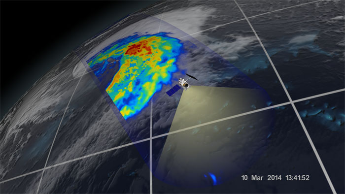
The images show precipitation falling inside a March 10 cyclone over the northwest Pacific Ocean, approximately 1,000 miles east of Japan. The data were collected by the GPM Core Observatory's two instruments: JAXA's Dual-frequency Precipitation Radar (DPR), which imaged a three-dimensional cross-section of the storm; and, NASA's GPM Microwave Imager (GMI), which observed precipitation across a broad swath.
"It was really exciting to see this high-quality GPM data for the first time," said GPM project scientist Gail Skofronick-Jackson at NASA's Goddard Spaceflight Center in Greenbelt, Md. "I knew we had entered a new era in measuring precipitation from space. We now can measure global precipitation of all types, from light drizzle to heavy downpours to falling snow."
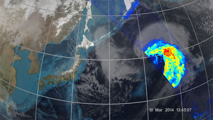
The satellite's capabilities are apparent in the first images of the cyclone. Cyclones such as the one imaged -- an extra-tropical cyclone -- occur when masses of warm air collide with masses of cold air north or south of the tropics. These storm systems can produce rain, snow, ice, high winds, and other severe weather. In these first images, the warm front ahead of the cyclone shows a broad area of precipitation -- in this case, rain -- with a narrower band of precipitation associated with the cold front trailing to the southwest. Snow is seen falling in the northern reaches of the storm.
The GMI instrument has 13 channels that measure natural energy radiated by Earth's surface and also by precipitation itself. Liquid raindrops and ice particles affect the microwave energy differently, so each channel is sensitive to a different precipitation type. With the addition of four new channels, the GPM Core Observatory is the first spacecraft designed to detect light rain and snowfall from space.
In addition to seeing all types of rain, GMI's technological advancements allow the instrument to identify rain structures as small as about 3 to 9 miles (5 to 15 kilometers) across. This higher resolution is a significant improvement over the capability of an earlier instrument flown on the Tropical Rainfall Measurement Mission in 1997.
"You can clearly see them in the GMI data because the resolution is that much better," said Skofronick-Jackson.
The DPR instrument adds another dimension to the observations that puts the data into high relief. The radar sends signals that bounce off the raindrops and snowflakes to reveal the 3D structure of the entire storm. Like GMI, its two frequencies are sensitive to different rain and snow particle sizes. One frequency senses heavy and moderate rain. A new, second radar frequency is sensitive to lighter rainfall and snowfall.
"Both return independent measurements of the size of raindrops or snowflakes and how they are distributed within the weather system," said DPR scientist Bob Meneghini at Goddard. "DPR allows scientists to see at what height different types of rain and snow or a mixture occur -- details that show what is happening inside sometimes complicated storm systems."
The DPR data, combined with data from GMI, also contribute to more accurate rain estimates. Scientists use the data from both instruments to calculate the rain rate, which is how much rain or snow falls to Earth. Rain rate is one of the Core Observatory's essential measurements for understanding where water is on Earth and where it's going.
"All this new information comes together to help us better understand how fresh water moves through Earth's system and contributes to things like floods and droughts," said Skofronick-Jackson.
.
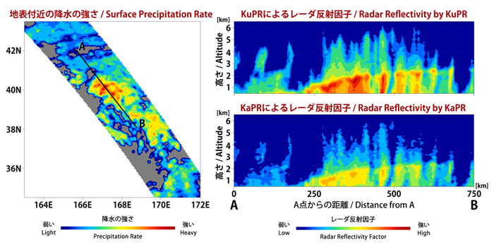
The Dual-frequency Precipitation Radar observes rainfall and snowfall that occurs within clouds in three dimensions, across the surface of Earth and upward into the atmosphere. An extra-tropical cyclone was observed over the northwest Pacific Ocean off the coast of Japan on March 10, 2014.
.
An extra-tropical cyclone seen off the coast of Japan, March 10, 2014, by the GPM Microwave Imager. The colors show the rain rate: red areas indicate heavy rainfall, while yellow and blue indicate less intense rainfall. The upper left blue areas indicate falling snow.
.
On March 10 the Core Observatory passed over an extra-tropical cyclone about 1,055 miles (1,700 km) east of Japan's Honshu Island. Formed when a cold air mass wrapped around a warm air mass near Okinawa on March 8, it moved NE drawing cold air over Japan before weakening over the North Pacific.
.
Quelle: NASA
6261 Views