
15.01.2020
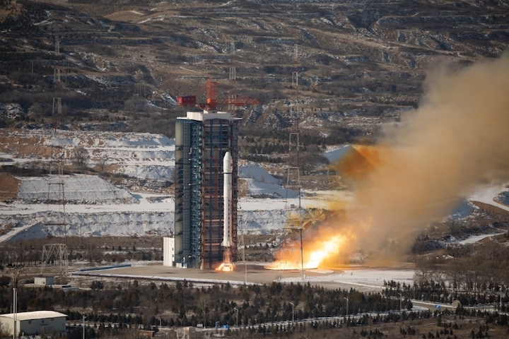
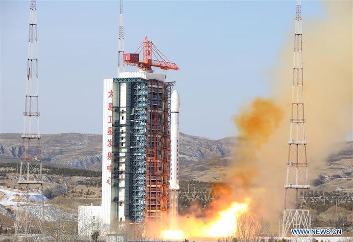
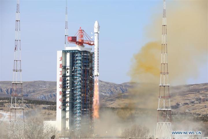
China launched another satellite for its Jilin-1 remote sensing constellation orbiting the Kuanfu-1 (Wideband-1) satellite from the Taiyuan Satellite Launch Center on January 15. The launch took place at around 02:53 UTC from the LC9 launch complex using the Long March-2D (Y58) rocket.
Together with Jilin-1 Kuanfu-1, the first mission from Taiyuan in 2020 orbited two new satellites for the Argentinian Aleph-1 constellation and the Chinese micro-satellite Renmin-1, although post launch information shows that was apparently replaced by Tianqi-5.
The Jilin-1 constellation:
The Jilin-1 satellite constellation was developed on China’s Jilin Province and is the country’s first self-developed remote sensing satellite for commercial use. Data will be provided to commercial clients to help them forecast and mitigate geological disasters, as well as shorten the time scale for the exploration of natural resources.
The satellites were developed by the Chang Guang Satellite Technology Co., Ltd under the Changchun Institute of Optics, Fine Mechanics and Physics, Chinese Academy of Sciences.
The satellite, Jilin-1 Gaofen-2B, is the 15th satellite of the constellation and is similar to the Jilin-1 Gaofen-2A orbited on November 13 by the Kuaizhou-1A (Y11) launched from the Jiuquan Satellite Launch Center. The new satellite will be operational at an altitude of 535 km orbit and it can obtain a static push-scan image with a full-color resolution better than 0.76 meters and a multi-spectral resolution better than 3.1meters. Images width is greater than 40 km. The images are transmitted to the ground stations via a digital transmission with a rate of 1.8Gbps. The launch weight is 230 kg.
Jilin, one of the country’s oldest industrial bases, is developing its satellite industry as a new economic driver. The province plans to launch 60 satellites by 2020 and 137 by 2030.
The first phase saw the launch of the first four Jilin-1 satellites on October 7, 2015. Jilin-1 Optical-A, LQSat (Jilin-1 Smart Verification Satellite), Lingqiao-A and Lingqiao-B were launched by the Long March-2D (Y37) from the Jiuquan Satellite Launch Center.
The fifth satellite, Jilin-1 Video-03, was launched on January 9, 2017. This was a remote sensing satellite for high definition video able to acquire visible light video data for high-resolution Earth observation. The satellite was launched by the Kuaizhou-1A (Y1) launcher from Jiuquan.
On November 21, 2017, three more satellites for the Jilin-1 constellations were launched. The Jilin-1 Video-4, 5 and 6 were launched by the Long March-6 (Y2) launch vehicle from the LC16 Launch Complex of the Taiyuan Satellite Launch Center. The three satellites featured a dual-imager with a 1-meter ground resolution for gaze video imaging, push-broom imaging, shimmer imaging and inertial space imaging.
Two more satellites were launched on January 19, 2018. Designated Deqing-1 (Jilin-1 Video-7) and Jilin Linye-2 (Jilin-1 Video-8), the two satellites were launched by the Long March-11 (Y20011703/Y3) from Jiuquan and were similar to the previous Video satellites.
Two hyperspectral satellites were launched on January 21, 2019. The Jilin Lincao-1 (Jilin-1 Hyperspectral-01) and Wenchang Chaosaun-1 (Jilin-1 Hyperspectral-02) featured a hyperspectral imager, providing a ground resolution of 5 meters and a swath width of 150 km in 26 spectral bands. The satellites were launched by the Long March-11 (Y20011806/Y6) rocket from Jiuquan.
Jilin-1 Gaofen-3A was launched on June 5, 2019, onboard the Long March-11H from the Yellow Sea. The satellite was equipped with a lightweight imaging system with a resolution of 1 meter, an image swath of 17 km.
Jilin-1 Gaofen-02A was launched from Jiuquan using the Kuaizhou-1A (Y11) and the similar Jilin-1 Gaofen-02B was launched on December 7 using the Kuaizhou-1A (Y2) from Taiyuan.
The original plan was to have 16 satellites in orbit until the end of 2019, completing a remote sensing network that will cover the entire globe and will be capable of a three to four hours update in the data provided. From 2020, the plans point to a 60 satellite orbital constellation capable of a 30 minutes update in the data provided.
From 2030 the Jilin constellation will have 138 satellites in orbit, forming an all-day, all-weather, full-spectrum acquisition segment data and a capability of observing any global arbitrary point with a 10 minutes revisit capability, providing the world’s highest spatial resolution and time resolution space information products.
The Aleph-1 satellites:
The Argentinian ÑuSat-7 ‘Sophie’ (Aleph-1 7) and ÑuSat-8 ‘Marie’ (Aleph-1 8) satellites are part of the Aleph-1 constellation that is being developed and operated by Satellogic S.A..
The Aleph-1 constellation will consist of up to 25 satellites.
The two satellites are almost identical to each other and have a mass of 37 kg, with dimensions 450mm x 450mm x 800mm. The primary objective of the mission is to commercially provide earth observation images to the general public in the visible and infrared parts of the spectrum.
The Aleph-1 constellation offers exclusive access to the insights the companies need with no capital outlay and no technical risk, offering uninterrupted coverage, rapid capability recovery and transparent hardware and software satellite updates.
The satellites allow for the management of forest lands, assets, and capital allocation, permitting the control over forest land use and track the evolution of any area frequently; preventing theft and illegal harvesting while receiving geo-alerts about impacted areas and their sizes anytime the changes are detected; will help define carbon stocks and fluxes for government reporting through empirical models that deliver a time series of carbon fluxes on a national scale; and help assess forest-stand variables while optimizing a company business operations and dynamically estimate forest-stand variables such as volume, yield, height, basal area, and DBH using predictive models.
In terms of agricultural management, the Aleph-1 constellation will help to manage agricultural land and assets, tracking land use, resources, and capital over time, while managing the supply chain efficiently and unlock market intelligence for the company’s business; it will prevent theft and illegal harvesting through geo-alerts about impacted areas and their sizes anytime changes are detected; will monitor crop health, pests, and weeds using Satellogic’s semantic segmentation technologies, to help clients to be able to see what they care about through augmentation lenses that can highlight everything from crop type and age, to the presence of pests; rationalize irrigation and use of chemicals and assess agricultural land characteristics with a tool specifically adapted to a company’s locations, experience, and expansion needs.
In the Energy Industries, the satellites will help to reduce operational costs and improve efficiency with automate pipeline integrity management, preventing illicit activities, comply with environmental regulations and to monitor infrastructure and assets.
In the fields of Finance and Insurance, the satellites will help to assess the impact and to monitor natural disasters and to access leading socioeconomic indicators for competitive intelligence.
Both satellites are equipped with cameras operating in visible light and infrared and will operate in 500 km SSO orbit with inclination at 97.5 degrees. The multispectral camera has a 1m resolution and the hyperspectral camera has a 30m resolution.
ÑuSat-7 is designated ‘Sophie’ in honor of Marie-Sophie Germain, (born April 1, 1776, Paris, France—died June 27, 1831, Paris), a French mathematician who contributed notably to the study of acoustics, elasticity, and the theory of numbers. ÑuSat-8 is designated ‘Marie’ in honor of Maria Salomea Skłodowska, (born November 7, 1867, Warsaw, Congress Kingdom of Poland, Russian Empire—died July 4, 1934, near Sallanches, France), a Polish-born French physicist, famous for her work on radioactivity and twice a winner of the Nobel Prize.
With Henri Becquerel and her husband, Pierre Curie, she was awarded the 1903 Nobel Prize for Physics. She was the sole winner of the 1911 Nobel Prize for Chemistry. She was the first woman to win a Nobel Prize, and she is the only woman to win the award in two different fields.
Tianqi-4:
The Renmin-1 satellite was supposed to be launching on this mission. However, some confusion was observed post-launch when this satellite wasn’t listed as separated. Instead a satellite called Tianqi-4 was cited as launching.
Tianqi-5, also designated Xinzhou/Yunjiang, is a low-orbit communication satellite operated by Guodian Gaoke for IoT communications, which is also carrying a camera for educational purposes.
The satellite is part of the “Apocalypse Constellation” that provides users with much-needed data collection and transmission services for terrestrial network coverage blind areas, which are widely used in marine, environmental protection, meteorological, forestry, geological, emergency, rescue and smart city industries to enhance China’s global data network coverage and application capabilities are of strategic importance.
Launch Vehicle and Launch Site:
The Long March-2D launch vehicle is a two-stage rocket developed by the Shanghai Academy of Spaceflight Technology. With storable propellants, it is mainly used to launch a variety of low earth orbit satellites.
The development of LM-2D was started in February 1990. From 2002, to meet the demand of SSO satellites, the payload fairing of 3350mm in diameter and attitude control engine for the second stage have been successfully developed; and the discharge of remaining propellant and de-orbit of the second stage have been realized. This launcher is mainly used for launching LEO and SSO satellites. It is characterized by high reliability, wide application and mature technology.
The LM-2D can launch a 1,300 kg cargo in a 645 km SSO. The rocket is 41.056m long and the first, second stages and payload fairing are all 3.35m in diameter.

Long March 2D during a previous mission
Its first stage is the same as the Long March-4. The second stage is based on LM-4 second stage with an improved equipment bay. Lift-off mass is 232,250 kg, total length 41,056 meters, diameter 3.35 meters and fairing length 6.983 meters. At launch, it develops 2961.6kN engine thrust.
The first stage has a 27.910 meter length with a 3.35 meter diameter, consuming 183,200 kg of N2O4 / UDMH (launch mass of the first stage is 192,700 kg). Equipped with a YF-21C engine capable of a ground thrust of 2,961.6 kN and a ground specific impulse of 2,550 m/s. Burn time is 170 seconds.
The second stage has a 10.9 meter length with a 3.35 meter diameter, launch mass of 39,550 kg and consuming 35,550 kg of N2O4 / UDMH. Equipped with a YF-24C cluster engine with a main engine vacuum thrust of 742.04 kN and a vernier engine with a vacuum thrust of 47.1 kN (specific impulses of 2,942 m/s and 2,834 m/s, respectively).
The LM-2D can use two types of fairings depending on the cargo. Type A fairing has a 2.90 meters diameter (total launch vehicle length is 37.728 meters) and Type B fairing with a diameter of 3.35 meters – total launch vehicle length is 41.056 meters.
The first launch of the LM-2D was on August 9th, 1992 from the Jiuquan Satellite Launch Center orbiting the Fanhui Shei Weixing FSW-2-1 (22072 1992-051A) recoverable satellite.
The launch took place from the Taiyuan Satellite Launch Center (TSLC). Situated in the Kelan County in the northwest part of the Shanxi Province, TSLC is also known by the Wuzhai designation. It is used mainly for polar launches (meteorological, Earth resources and scientific satellites).
The launch center has two single-pad launch complexes, a technical area for rocket and spacecraft preparations, a communications center, a mission command and control center, and a space tracking center.

Taiyuan Satellite Launch Center
The stages of the rocket were transported to the launch center by railway and offloaded at a transit station south of the launch complex. They were then transported by road to the technical area for checkout procedures.
The launch vehicles were assembled on the launch pad by using a crane at the top of the umbilical tower to hoist each stage of the vehicle in place. Satellites were airlifted to the Taiyuan Wusu Airport about 300km away and then transported to the center by road.
The TT&C Centre, also known as Lüliang Command Post, is headquartered in the city of Taiyuan, It has four subordinate radar tracking stations in Yangqu (Shanxi), Lishi (Shanxi), Yulin (Shaanxi), and Hancheng (Shaanxi).
Quelle: NS
+++
China launches new remote-sensing satellite
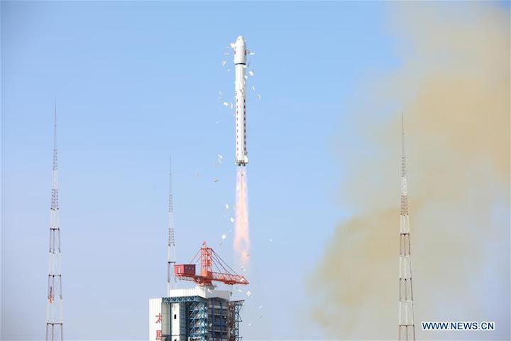
The new optical remote-sensing satellite for commercial use Red Flag-1 H9, along with three small satellites, is launched by a Long March-2D carrier rocket from the Taiyuan Satellite Launch Center in north China's Shanxi Province, Jan. 15, 2020. China sent a new optical remote-sensing satellite for commercial use into planned orbit from the Taiyuan Satellite Launch Center in north China's Shanxi Province on Wednesday morning. The satellite, belonging to the Jilin-1 satellite family, also named Red Flag-1 H9, was launched by a Long March-2D carrier rocket at 10:53 a.m. Beijing time. The new satellite, developed by the Chang Guang Satellite Technology Co., Ltd., has a super-wide coverage and a resolution at the sub-meter level. It is also capable of high-speed data storage and transmission. Via the same carrier rocket, three small satellites including NewSat7 and NewSat8 developed by an Argentinian company were also sent into space. (Photo by Lu Xing/Xinhua)
China sent a new optical remote-sensing satellite for commercial use into planned orbit from the Taiyuan Satellite Launch Center in north China's Shanxi Province on Wednesday morning.
The satellite, belonging to the Jilin-1 satellite family, also named Red Flag-1 H9, was launched by a Long March-2D carrier rocket at 10:53 a.m. Beijing time.
The new satellite, developed by the Chang Guang Satellite Technology Co., Ltd., has a super-wide coverage and a resolution at the sub-meter level. It is also capable of high-speed data storage and transmission.
It will work with the 15 satellites of the Jilin-1 family already sent into orbit to form a constellation that will provide remote-sensing data and services for governmental and industrial users.
Via the same carrier rocket, three small satellites including NewSat7 and NewSat8 developed by an Argentinian company were also sent into space.
The Long March-2D carrier rocket was developed by the Shanghai Academy of Spaceflight Technology under the China Aerospace Science and Technology Corporation.
Wednesday's launch was the 325th mission of the Long March series carrier rockets.
Quelle: Xinhua