15.01.2022

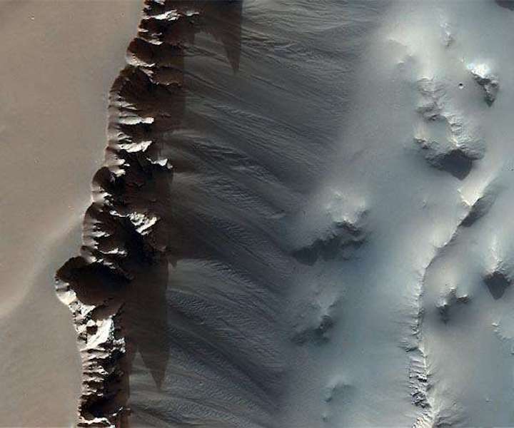
The image was taken over the easternmost part of Noctis Labyrinthus at 265.8E/8.70S in the Phoenicis Lacus Quadrangle, near the intersection with Lus Chasma of Valles Marineris - the 'grand canyon' of Mars.
There's more to this image of Mars than first meets the eye: nestled in the detail of the cliff face that cuts through this scene are signs of geology in motion. Zooming in reveals several boulders that have fallen from the cliff edge, leaving small dimples in the soft material as they tumbled down-slope.
The image was taken by the CaSSIS camera onboard the ESA/Roscosmos ExoMars Trace Gas Orbiter on 3 August 2020, and captures a slice through the maze-like system of the aptly named Noctis Labyrinthus.
The cliff-like feature running through the central portion of the image is part of a horst-graben system, which comprises raised ridges and plateaus (horst) either side of sunken valleys (graben) created as a result of tectonic processes that pulled the planet's surface apart. The entire network of plateaus and trenches making up Noctis Labyrinthus spans some 1200 km, with individual cliffs reaching 5 km above the surface below.
Elsewhere in this image and in particular towards the right-hand side are patches of linear ripples that have been shaped by the wind. A few small impact craters also pockmark the scene.
The image was taken over the easternmost part of Noctis Labyrinthus at 265.8E/8.70S in the Phoenicis Lacus Quadrangle, near the intersection with Lus Chasma of Valles Marineris - the 'grand canyon' of Mars.
TGO arrived at Mars in 2016 and began its full science mission in 2018. The spacecraft is not only returning spectacular images, but also providing the best ever inventory of the planet's atmospheric gases, and mapping the planet's surface for water-rich locations. It will also provide data relay services for the second ExoMars mission comprising the Rosalind Franklin rover and Kazachok platform, when it arrives on Mars in 2023.
Quelle: SD
