
23.08.2025
NASA’s Perseverance rover captures stunning Mars vista
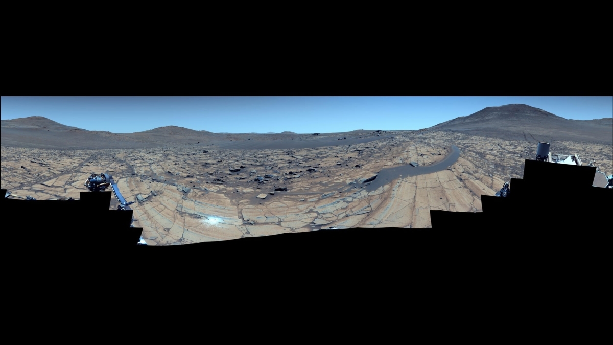
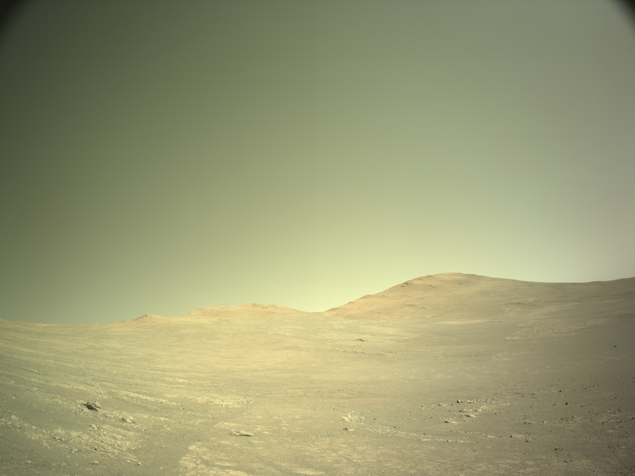
The imaging team of NASA’s Perseverance Mars rover took advantage of clear skies on the red planet to capture one of the sharpest panoramas of its mission so far.
Visible in the mosaic, which was stitched together from 96 images taken at a location the science team calls “Falbreen,” is a rock that appears to lie on top of a sand ripple, a boundary line between two geologic units and hills as distant as 40 miles away. The enhanced-color version shows the Martian sky to be remarkably clear and deceptively blue, while in the natural-color version, it’s reddish.
“Our bold push for human space exploration will send astronauts back to the moon,” said Sean Duffy, acting NASA administrator. “Stunning vistas like that of Falbreen, captured by our Perseverance rover, are just a glimpse of what we’ll soon witness with our own eyes. NASA’s groundbreaking missions, starting with Artemis, will propel our unstoppable journey to take human space exploration to the Martian surface. NASA is continuing to get bolder and stronger.”
The rover’s Mastcam-Z instrument captured the images on May 26, the 1,516th Martian day, or sol, of Perseverance’s mission, which began in February 2021 on the floor of Jezero Crater. Perseverance reached the top of the crater rim late last year.
“The relatively dust-free skies provide a clear view of the surrounding terrain,” said Jim Bell, Mastcam-Z’s principal investigator at Arizona State University in Tempe. “And in this particular mosaic, we have enhanced the color contrast, which accentuates the differences in the terrain and sky.”
Buoyant boulder
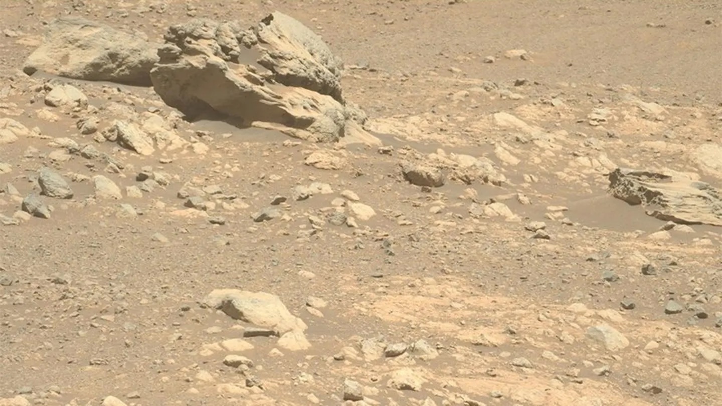
One detail that caught the science team’s attention is a large rock that appears to sit atop a dark, crescent-shaped sand ripple to the right of the mosaic’s center, about 14 feet from the rover. Geologists call this type of rock a “float rock” because it was more than likely formed someplace else and transported to its current location. Whether this one arrived by a landslide, water or wind is unknown, but the science team suspects it got here before the sand ripple formed.
The bright white circle just left of center and near the bottom of the image is an abrasion patch. This is the 43rd rock Perseverance has abraded since it landed on Mars. Two inches wide, the shallow patch is made with the rover’s drill and enables the science team to see what’s beneaththe weathered, dusty surface of a rock before deciding to drill a core sample that would be stored in one of the mission’s titanium sample tubes.
The rover made this abrasion on May 22 and performed proximity science (a detailed analysis of Martian rocks and soil) with its arm-mounted instruments two days later. The science team wanted to learn about Falbreen because it’s situated within what may be some of the oldest terrain Perseverance has ever explored — perhaps even older than Jezero Crater.
Tracks from the rover’s journey to the location can be seen toward the mosaic’s right edge. About 300 feet away, they veer to the left, disappearing from sight at a previous geologic stop the science team calls “Kenmore.”
A little more than halfway up the mosaic, sweeping from one edge to the other, is the transition from lighter-toned to darker-toned rocks. This is the boundary line, or contact, between two geologic units. The flat, lighter-colored rocks nearer to the rover are rich in the mineral olivine, while the darker rocks farther away are believed to be much older clay-bearing rocks.
Quelle: Arizona State University
----
Update: 30.08.2025
.
Perseverance Mars rover stumbles upon wind-carved 'megaripples' on the Red Planet
"On Mars, the past is written in stone — but the present is written in sand."
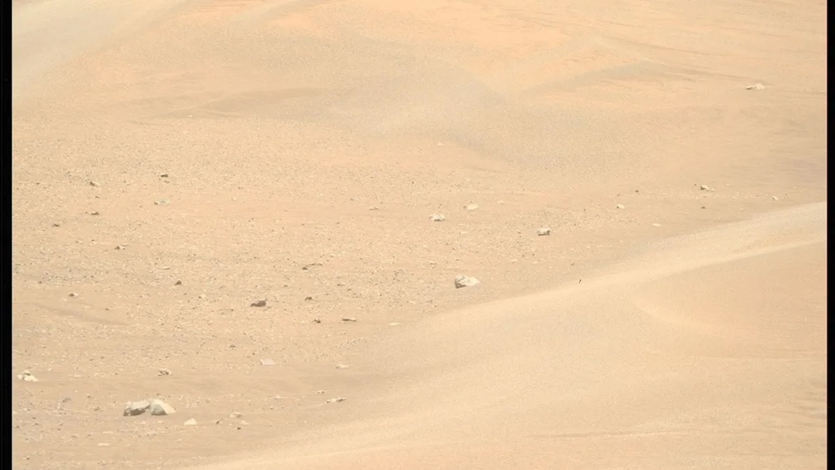
NASA's Perseverance rover captured this image of inactive megaripples at a site called "Kerrlaguna" on Aug. 13, 2025 as part of the rover's exploration of wind-shaped features on Mars. (Image credit: NASA/JPL-Caltech/ASU)
NASA's Perseverance rover has captured a striking new image of massive, wind-carved sand formations known as "megaripples" during its latest exploration stop on the Red Planet.
The photo, taken on Aug. 13, reveals a field of these ridges at a site called Kerrlaguna, where Perseverance is investigating how Martian winds continue to shape the landscape. According to a recent NASA statement, this work is part of a broader effort to better understand Mars' modern environment.
"On Mars, the past is written in stone — but the present is written in sand," the statement says.
Megaripples are sandy ridges that rise up to about three feet (one meter) high. Found across much of the Martian surface, they fall in size between smaller ripples and larger sand dunes. Many are thought to be remnants from a time when Mars had a thicker atmosphere and stronger winds, possibly indicating shifts in climate over millions of years. Some even show signs of fractured crests, hinting at long-term exposure to changing conditions.
At Kerrlaguna, the megaripples are considered "inactive," meaning they haven't visibly shifted in recent years. Previous research has shown that unlike ripples on Earth, which shift constantly under the influence of wind and water, Martian megaripples consist of fine sand beneath a layer of coarse grains. This makes them more resistant to drifting by wind.
Still, high-resolution satellite observations have shown that some megaripples across Mars do move — albeit slowly, creeping about one meter every nine Earth years. While sluggish compared to active dunes, this movement is still evidence that the Martian surface is not geologically dead as was once thought, scientists say.
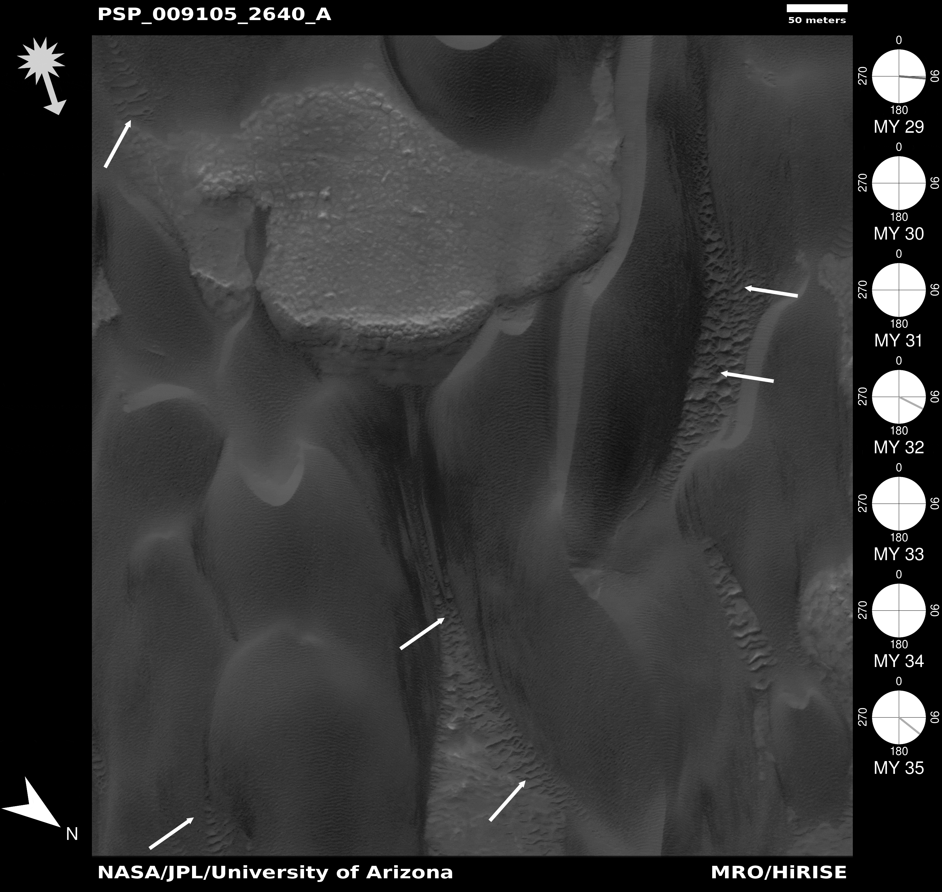
A gif showing the change in wind patterns over the sand dunes of Mars
"The field is evolving in the sense that high-resolution images have finally been obtained over a long enough time span to allow the megaripple movement to be detected," Jim Zimbelman, a planetary geologist at the Smithsonian's National Air and Space Museum, previously told Astronomy Magazine.
Some of the most dynamic examples have been observed in Mars' north polar region, where wintertime carbon dioxide ice temporarily cements dunes and ripples. When spring arrives, the ice sublimates and summertime winds reawaken the movement of the sand.
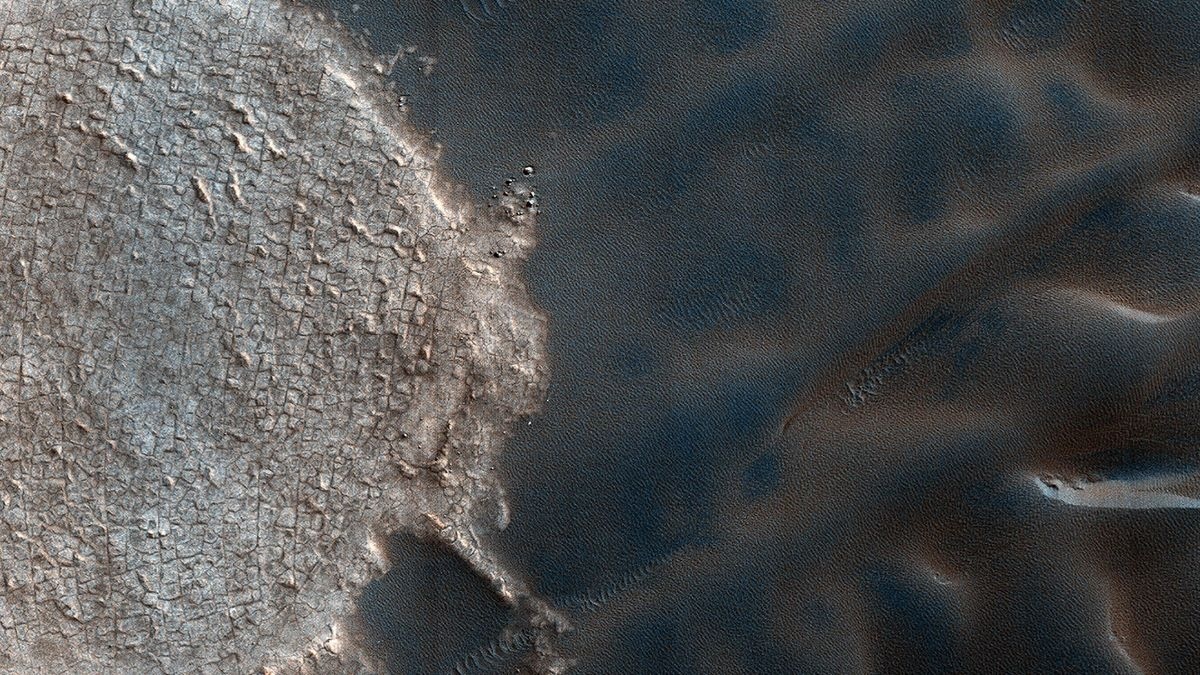
Ripple patterns can be seen in the sand dunes on the surface of Mars. (Image credit: NASA/JPL-Caltech/University of Arizona)
To investigate the features at Kerrlaguna, Perseverance deployed several of its science instruments, including cameras and tools for analyzing the chemistry and structure of rock and soil. These help scientists study the size, layering and composition of sand grains, as well as detect salty crusts that may have formed over time.
Such crusts could hold clues about past interactions with water, and may even offer valuable resources for future human missions. These findings "help us prepare for the day when astronauts explore the Red Planet and need resources held within Martian soils to help them survive," the statement says.
The rover's stop at Kerrlaguna follows an earlier attempt to climb a rocky slope toward a site called Midtoya, where Perseverance struggled to make progress over loose, uneven terrain and ultimately turned back, the agency said.
Still, the effort yielded valuable data after the rover analyzed several rocks that likely rolled down from Midtoya, including one rock dubbed "Horneflya," which drew attention online for its unusual, medieval helmet-like shape.
This isn't NASA's first encounter with Martian sand formations. Nearly a decade ago, the Curiosity rover studied active dunes at "Namib Dune" and took one of its most iconic selfiesthere. But while active dunes provide dynamic views of surface change, scientists now see just as much value in studying the slower-moving, dust-covered megaripples like those at Kerrlaguna that help reveal how Mars has changed over time.
Perseverance's investigation at Kerrlaguna is only a preview, according to the statement. The rover is expected to continue south toward a larger field of megaripples at a site called "Lac de Charmes," where NASA plans a more in-depth campaign.
"While often the rover's attention is focused on studying processes in Mars' distant past that are recorded in ancient rocks, we still have much to learn about the modern Martian environment," the statement says.
Quelle: SC
----
Update: 10.09.2025
.
Perseverance Meets the Megabreccia
Written by By Henry Manelski, Ph.D. student at Purdue University
Last week, the Perseverance rover began an exciting new journey. Driving northwest of theSoroya ridge, Perseverance entered an area filled with a diverse range of boulders that the science team believes could hold clues to Mars’ early history. The terrain we are exploring is known as megabreccia: a chaotic mixture of broken rock fragments likely produced during ancient asteroid impacts. Some blocks may have originated in the gargantuan Isidis impact event, which created a 1,200-mile-wide crater (about 1,930 kilometers) just east of Jezero. Studying megabreccia could help us link Jezero’s geology to the wider region around Isidis Basin, tying local observations to Mars’ global history.
The rover is now beginning a systematic exploration of these rocks, starting at Scotiafjellet. If they are truly megabreccia, they could contain pieces of deep crustal material, offering a rare glimpse into Mars’ interior. These rocks likely predate the deltaic and volcanic deposits we explored earlier in Jezero Crater, making them some of the oldest accessible rocks Perseverance will ever encounter. They may therefore reveal to what extent water was present on ancient Mars — a key question as we continue our search for signs of past life on the Red Planet. In short, by venturing into this jumbled terrain, Perseverance is giving us a front-row seat to the earliest chapters of Mars’ story.
Quelle: NASA
+++
NASA to Share Details of New Perseverance Mars Rover Finding
NASA will host a media teleconference at 11 a.m. EDT Wednesday, Sept. 10, to discuss the analysis of a rock sampled by the agency’s Perseverance Mars rover last year, which is the subject of a forthcoming science paper.
The sample, called “Sapphire Canyon,” was collected in July 2024 from a set of rocky outcrops on the edges of Neretva Vallis, a river valley carved by water rushing into Jezero Crater long ago.
Audio and visuals of the call will stream on the agency’s website at:
Participants in the teleconference include:
- Acting NASA Administrator Sean Duffy
- Nicky Fox, associate administrator, Science Mission Directorate, NASA Headquarters in Washington
- Lindsay Hays, Senior Scientist for Mars Exploration, Planetary Science Division, NASA Headquarters
- Katie Stack Morgan, Perseverance Project Scientist, NASA’s Jet Propulsion Laboratory in Southern California
- Joel Hurowitz, planetary scientist, Stony Brook University, New York
To ask questions by phone, members of the media must RSVP no later than two hours before the start of the event to: rexana.v.vizza@jpl.nasa.gov. NASA’s media accreditation policy is available online.
Since landing in the Red Planet’s Jezero Crater in February 2021, Perseverance has collected 30 samples. The rover still has six empty sample tubes to fill, and it continues to collect detailed information about geologic targets that it hasn’t sampled by using its abrasion tool. Among the rover’s science instruments is a weather station that provides environmental information for future human missions, as well as swatches of spacesuit material so that NASA can study how it fares on Mars.
Managed for NASA by Caltech, JPL built and manages operations of the Perseverance rover on behalf of the agency’s Science Mission Directorate as part of NASA’s Mars Exploration Program portfolio.
Quelle: NASA
----
Update: 21.11.2025
.
Perseverance rover spots mysterious 'visitor from outer space' rock on Mars surface after 4 years
Shiny rock nicknamed 'Phippsaksla' shows high iron and nickel levels suggesting meteorite origin
NASA’s Perseverance rover may have stumbled on a visitor from outer space – a strange, shiny rock on Mars that scientists think could be a meteorite forged in the heart of an ancient asteroid.
According to a new blog post on the rover’s mission page, the rock – nicknamed "Phippsaksla" – stood out from the flat, broken terrain around it, prompting NASA scientists to take a closer look.
Tests revealed high levels of iron and nickel, the same elements found in meteorites that have crashed onto both Mars and Earth.
While this isn’t the first time a rover has spotted a metallic rock on Mars, it could be the first for Perseverance. Earlier missions – including Curiosity, Opportunity and Spirit – discovered iron-nickel meteorites scattered across the Martian surface, making it all the more surprising that Perseverance hadn’t seen one until now, NASA said.
NASA’s Perseverance rover discovered a shiny metallic rock that scientists believe could be a meteorite forged in the heart of an ancient asteroid. (NASA
Now, just beyond the crater’s rim, the rover may have finally found one – a metallic rock perched on ancient impact-formed bedrock. If confirmed, the discovery would place Perseverance alongside the other Mars rovers that have examined fragments of cosmic visitors to the red planet.
To learn more about the rock, the team aimed Perseverance’s SuperCam – an instrument that fires a laser to analyze a target’s chemical makeup – at Phippsaksla. The readings showed unusually high levels of iron and nickel, a combination NASA said strongly suggests a meteorite origin.
Mounted atop the rover’s mast, SuperCam uses its laser to vaporize tiny bits of material, so sensors can detect the elements inside from several meters away.
The shiny rock nicknamed "Phippsaksla," discovered by NASA’s Perseverance rover, showed high levels of iron and nickel consistent with meteorites found on Mars and Earth. (NASA)
The finding is significant, NASA noted, because iron and nickel are typically found together only in meteorites formed deep within ancient asteroids – not in native Martian rocks.
If confirmed, Phippsaksla would join a long list of meteorites identified by earlier missions, including Curiosity’s "Lebanon" and "Cacao" finds, as well as metallic fragments spotted by Opportunity and Spirit. NASA said each discovery has helped scientists better understand how meteorites interact with the Martian surface over time.
Because Phippsaksla sits atop impact-formed bedrock outside Jezero crater, NASA scientists said its location could offer clues about how the rock formed and how it ended up there.
NASA scientists say the metallic rock spotted by Perseverance may be a meteorite formed deep within an ancient asteroid before crashing onto Mars. (NASA)
For now, the agency said its team is continuing to study Phippsaksla’s unusual makeup to confirm whether it truly came from beyond Mars.
If proven to be a meteorite, the find would mark a long-awaited milestone for Perseverance – and another reminder that even on a planet 140 million miles away, there are still surprises waiting in the dust.
Perseverance, NASA’s most advanced robot to date, traveled 293 million miles to reach Mars after launching on a United Launch Alliance Atlas V rocket from Cape Canaveral Space Station in Florida on July 30, 2020. It touched down in Jezero crater on Feb. 18, 2021, where it has spent nearly four years searching for signs of ancient microbial life and exploring the planet’s surface.
Built at NASA’s Jet Propulsion Laboratory in Pasadena, California, the $2.7 billion rover is about 10 feet long, 9 feet wide and 7 feet tall – roughly 278 pounds heavier than its predecessor, Curiosity.
Powered by a plutonium generator, Perseverance carries seven scientific instruments, a seven-foot robotic arm and a rock drill that allows it to collect samples that could one day return to Earth.
The mission will also help NASA prepare for future human exploration of Mars in the 2030s.