12.12.2024

Less than a week after its launch, the Copernicus Sentinel-1C satellite has delivered its first radar images of Earth – offering a glimpse into its capabilities for environmental monitoring. These initial images feature regions of interest, including Svalbard in Norway, the Netherlands, and Brussels, Belgium.
Launched on 5 December from Europe’s Spaceport in French Guiana aboard a Vega-C rocket, Sentinel-1C is equipped with a state-of-the-art C-band synthetic aperture radar (SAR) instrument. This cutting-edge technology allows the satellite to deliver high-resolution imagery day and night, in all weather conditions, supporting critical applications such as environmental management, disaster response and climate change research.
Now, the new satellite has delivered its initial set of radar images over Europe, flawlessly processed by the Copernicus Ground Segment. These images showcase an exceptional level of data quality for initial imagery, highlighting the outstanding efforts of the entire Sentinel-1 team over the past years.
The first image, captured just 56 hours and 23 minutes after liftoff, features Svalbard, a remote Norwegian archipelago in the Arctic Ocean.

This image demonstrates Sentinel-1C’s ability to monitor ice coverage and environmental changes in harsh and isolated regions. These capabilities are essential for understanding the effects of climate change on polar ecosystems and for enabling safer navigation in Arctic waters.
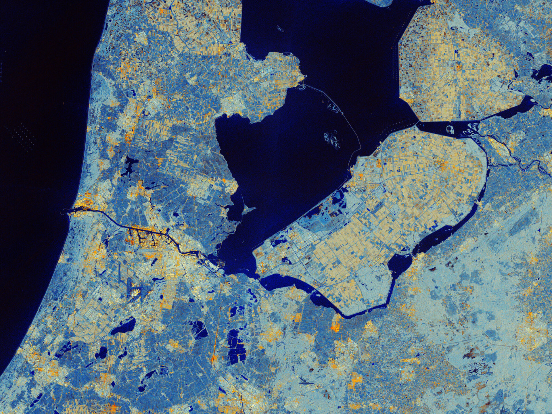
Moving to mainland Europe, the second image showcases part of the Netherlands, including Amsterdam and the region of Flevoland, renowned for its extensive farmland and advanced water management systems.
Sentinel-1C’s advanced radar captures intricate details of this region, providing invaluable data for monitoring soil moisture and assessing crop health. These insights are essential for enhancing agricultural productivity and ensuring sustainable resource management in one of Europe’s key farming areas.

This Sentinel-1C image of the Netherlands echoes the very first SAR image acquired by the legacy European Remote-Sensing (ERS) mission in 1991, which captured the Flevoland polder and the Ijsselmeer – marking the first European radar image ever taken from space.
Finally, the third image highlights Brussels, Belgium, where Sentinel-1C’s radar technology vividly depicts the dense urban landscape in bright white and yellow tones, contrasting with the surrounding vegetation. Waterways and low-reflective areas, such as airport runways, appear in darker hues.

Interestingly, Brussels holds historical significance for the Sentinel programme, as it was the subject of the first radar image captured by Sentinel-1A in April 2014.
The European Commission oversees Copernicus, coordinating diverse services aimed at environmental protection and enhancing daily life. While ESA, responsible for the Sentinel satellite family, ensures a steady flow of high-quality data to support these services.
ESA’s Director of Earth Observation Programmes, Simonetta Cheli, commented, “These images highlight Sentinel-1C’s remarkable capabilities. Although it’s early days, the data already demonstrate how this mission will enhance Copernicus services for the benefit of Europe and beyond.”
Since its launch, Sentinel-1C has undergone a series of complex deployment procedures, including the activation of its 12-meter-long radar antenna and solar arrays.

While the satellite is still in its commissioning phase, these early images underscore its potential to deliver actionable insights across a range of environmental and scientific applications.
Reflecting on the Sentinel-1C launch, Ramon Torres, ESA’s Project Manager for the Sentinel-1 mission, said: “Sentinel-1C is now poised to continue the critical work of its predecessors, unveiling secrets of our planet—from monitoring the movements of ships on vast oceans to capturing the dazzling reflections of sea ice in polar regions and the subtle shifts of Earth's surface. These first images embody a moment of renewal for the Sentinel-1 mission.’”
Sentinel-1 data contributes to numerous Copernicus services and applications, including Arctic sea-ice monitoring, iceberg tracking, routine sea-ice mapping and glacier-velocity measurements. It also plays a vital role in marine surveillance, such as oil-spill detection, ship tracking for maritime security and monitoring illegal fishing activities.
Additionally, it is widely used for observing ground deformation caused by subsidence, earthquakes and volcanic activity, as well as for mapping forests, water and soil resources. The mission is crucial in supporting humanitarian aid and responding to crises worldwide.
All Sentinel-1 data are freely available via the Copernicus Data Space Ecosystem, providing instant access to a wide range of data from both the Copernicus Sentinel missions and the Copernicus Contributing Missions.
Quelle: ESA
