15.11.2023

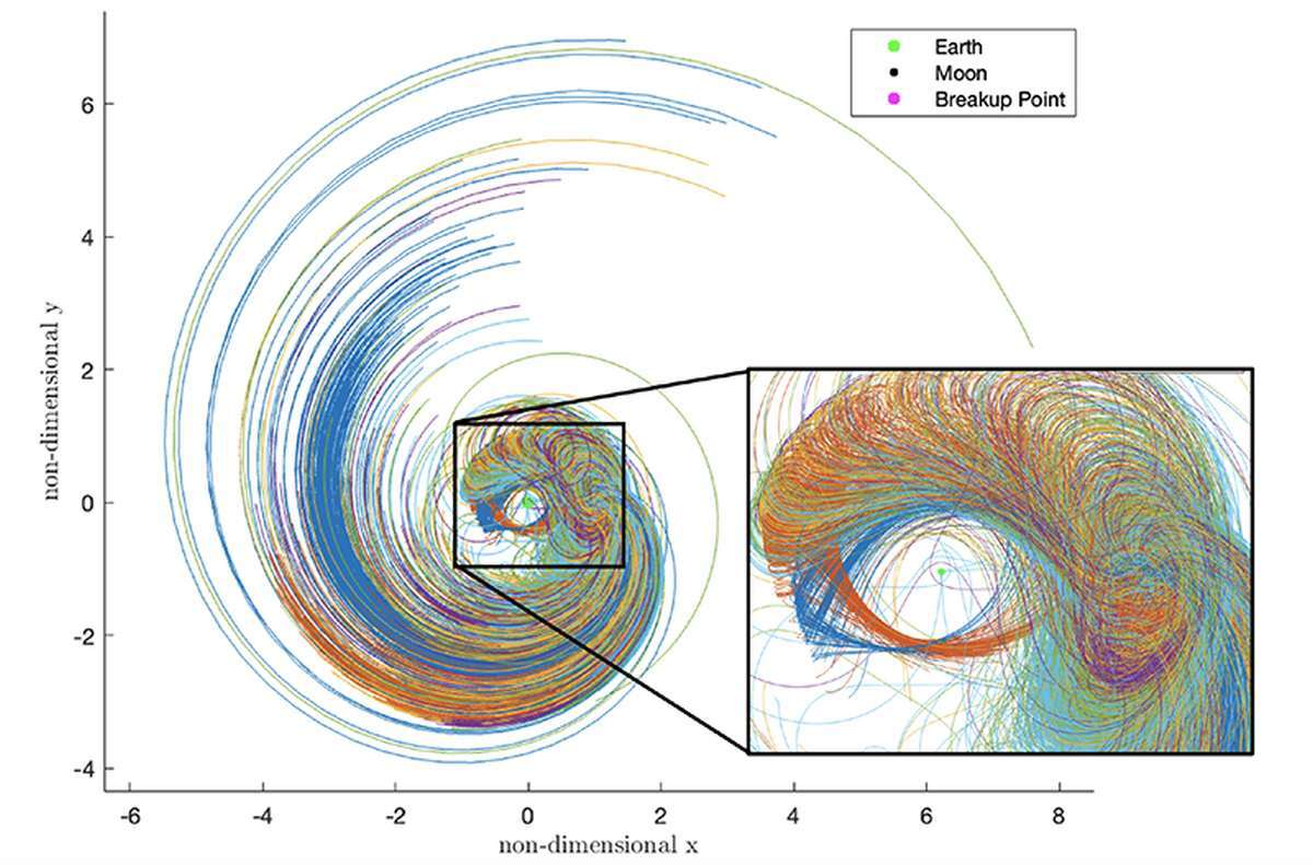
In this chart, fragments of an exploded spacecraft near the moon are predicted to disperse millions of miles away within just a month’s time depending on the orbit where the explosion took place. The length of each coloured line in this chart indicates how far fragments could spread in 30 days from one explosion point on an orbit of the Lyapunov orbit family around a location called the second Lagrange "L2" point. These orbits are being considered for cislunar missions. On each orbit, the explosion point is assumed to be in line with Earth and the moon. (Purdue University image/Ariel Black and Carolin Frueh)
As low-Earth orbits get increasingly crowded, businesses and governments are looking up. At the same time, the race to establish an outpost on the Moon is speeding up. Together, they represent a rapidly emerging new headache for space traffic control.
Adelaide-based Saber Astronautics has won a $1.2 million contract from the US Space Force (USSF) to produce a new navigation tool tailored to account for the gravitational eddies and riptides of this CisLunar (between the Earth and the Moon) frontier.
“We’ve got all these gravitational effects we’ve got to deal with,” says CEO and founder Dr Jason Held. “It’s pretty cool, actually – the orbits end up looking like flowers as the Moon grabs you at one point and then the Earth at another.”
The thousands of objects hurtling about in relatively simple circles between 160km and 1000km above the Earth present a difficult enough challenge for space domain awareness operators as it is. But predicting potential collisions and detecting unusual movements in any orbit is both a commercial and national security imperative.
And higher orbits are getting busier.

“There’s two trends,” Held told Cosmos. “The civilian trend is quite simple: people see revenue opportunities in the space between GEO (35,785km) and Lunar (384,400 km) orbits. I’ve seen about half a dozen business plans and proposals to build something to do something in that CisLunar space. It’s a good place for observation satellites, for example, whether looking down on the Earth or outwards as a space observatory.
“The military use has been around for about 3-5 years already, and that’s the dance we see between nation states in the GEO belt doing ‘inspection’ orbits.”
Held says most sensors and telescopes are designed to track spacecraft movements up to GEO orbits – the domain of multi-billion-dollar communications, weather, spy and some navigation satellites. And that means operators who want to slip out of view send their craft into CisLunar space for a while, where it can manoeuvre unobserved before returning from an unanticipated direction.
And then there’s the looming “rush” of satellites, space stations, and landers headed to the Moon. At a quarter the size of Earth and with 16.6 per cent of the gravity, its “bumpy” orbital highways will likely fill fast.
“People are anticipating the Lunar region as a region of future commercial interest, so they’re getting their infrastructure set up now,” says Held. “The race for that market has begun, but it isn’t here yet.”

Saber is working with Purdue University astrodynamics researchers to turn the complex orbital gravitational maps that apply to these orbits into an “app” for its existing Space Cockpit space domain monitoring and management software.
The tool is used by the USSF and more than 2000 other operators worldwide. But it needs a new set of predictive algorithms to account for the gravitational shoals at these higher altitudes.
“How do you do that? Well, it’s a fundamental navigation problem,” says Held. “It’s the math that combines them. And that’s why we partnered with Purdue – because they have the math and we have the framework that can use it. The back end of that technology can take years to set up. But we’ve tackled it already”.
The new Saber app is a sandbox, enabling space operators to explore theoretical scenarios to determine what is possible in these poorly monitored regions. And it’s an app existing users of the Space Cockpit – be they military or commercial – will be able to access.
“It’s about predicting theoretical scenarios and trying to determine what people can do and where they can go – how they can use this new CisLunar regime,” Held concludes.
Quelle: COSMOS
