
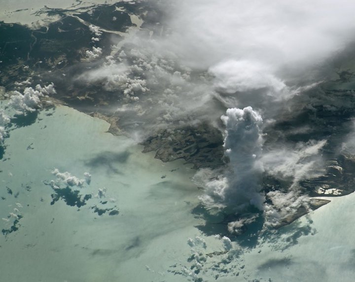
It looks like a ghostly medieval tower — like something out of "Game of Thrones" — looming over the crystal-blue Caribbean waters of the Bahamas. But the feature captured in an arresting photo by an astronaut aboard the International Space Station is actually a product of Mother Nature, a towering cumulus cloud that formed as warm air from the Earth's surface shot up into the sky.
The types of clouds in the sky can tell you a lot about what's happening in the atmosphere — whether air is rising or descending, how the temperature or winds change with height and whether storms are on the way.
Wispy, feathery cirrus clouds high in the atmosphere are typically seen in fair weather, though they can be one of the first signs that a warm front is about to move through. Those featureless, gray stratus clouds that hang close to the ground can form when a mass of warm air moves over a cooler region, causing water vapor in the air to condense into water droplets.
NASA's Earth Observatory, which released the photo Jan. 15, called the cloud column in the astronaut photo a "cumulus castellanus," to describe the castle-esque look of the fluffy, cotton ball-like texture most people think of when they think of clouds. But, strictly speaking, cumulus castellanus isn't actually a thing.
Specific types of cumulus and cirrus clouds can be of the castellanus variety, and these feature several chunks of clouds jutting up, giving the appearance of a castle's turrets (hence the name), according to the International Cloud Atlas.
The cloud in the astronaut photo is what meteorologist Peggy LeMone would call a "towering cumulus," which she estimated is about 10,000 to 15,000 feet (about 3,000 to 4,500 meters) tall. And it tells you some interesting things about the atmosphere over the Bahamas' Andros Island on July 19, 2016, when the photo was taken.
"You notice how it's going straight up," LeMone, an emeritus scientist with the National Center for Atmospheric Research in Boulder, Colorado, said. "That means that the wind isn't changing that much with height." If the wind were blowing faster higher in the atmosphere, the tower would be leaning.
The cloud formed from a bubble of hot air that rose straight up into the atmosphere in what's called an updraft, she said, with water condensing out as the air cooled at higher altitudes. The bubble of hot air likely formed because the air over Andros Island warmed up faster than the air over the surrounding ocean, since land heats up faster than water.

It's difficult to tell from the photo whether rain is falling from the cloud. Generally, however, when such a cumulus cloud column creates a thunderstorm "it'll kill itself" because the rain falling into the updraft creates a countering downdraft, and the whole thing fizzles out, LeMone said.
The imposing masses of billowing cumulonimbus clouds that characterize the thunderstorms that roll across North America and other areas in the middle latitudes tend to be tilting because of winds blowing faster or in different directions higher up in the atmosphere, LeMone said.. This causes the rain to fall away from the updraft, maintaining the storm.
If rain is falling from the cloud in the photo, it is technically a cumulonimbus cloud (nimbus is the Latin word for rain), though a "wimpy" one, according to LeMone. And it shows that the cloud classifications created to describe the clouds observed over Europe and North America don't quite work for the clouds of the tropics, she said. "The tropical clouds just don't fit well."
Quelle: SC