
.
7.04.2016
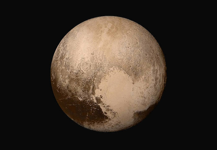
Icy ‘Spider’ on Pluto
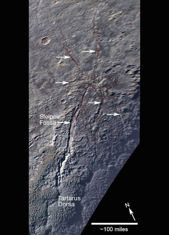
Pluto’s unusual spider-like feature consists of at least six extensional fractures that converge to a point. Individual fractures can reach hundreds of miles long and appear to expose a reddish subsurface layer.
Credits: NASA/JHUAPL/SwRI
-
Sprawling across Pluto’s icy landscape is an unusual geological feature that resembles a giant spider.
“Oh, what a tangled web Pluto’s geology weaves,” said Oliver White, a member of the New Horizons geology team from NASA Ames Research Center, Moffett Field, California. “The pattern these fractures form is like nothing else we’ve seen in the outer solar system, and shows once again that anywhere we look on Pluto, we see something different.”
As shown in the enhanced color image above – obtained by NASA’s New Horizons spacecraft on July 14, 2015 – this feature consists of at least six extensional fractures (indicated by white arrows) converging to a point near the center. The longest fractures are aligned roughly north-south, and the longest of all, the informally named Sleipnir Fossa, is more than 360 miles (580 kilometers) long. The fracture aligned east-west is shorter and is less than 60 miles (100 kilometers) long. To the north and west, the fractures extend across the mottled, rolling plains of the high northern latitudes, and to the south, they intercept and cut through the bladed terrain informally named Tartarus Dorsa.
Curiously, the spider’s “legs” noticeably expose red deposits below Pluto’s surface.
New Horizons scientists think fractures seen elsewhere on Pluto – which tend to run parallel to one another in long belts – are caused by global-scale extension of Pluto’s water–ice crust. The curious radiating pattern of the fractures forming the “spider” may instead be caused by a focused source of stress in the crust under the point where the fractures converge – for example, due to material welling up from under the surface. The spider somewhat resembles radially fractured centers on Venus called novae, seen by NASA’s Magellan spacecraft, as well as the Pantheon Fossae formation, seen by NASA’s MESSENGER spacecraft on Mercury.
This image was obtained by New Horizons’ Ralph/Multispectral Visible Imaging Camera (MVIC). The image resolution is approximately 2,230 feet (680 meters) per pixel. It was obtained at a range of approximately 21,100 miles (33,900 kilometers) from Pluto, about 45 minutes before New Horizons’ closest approach on July 14, 2015.
.
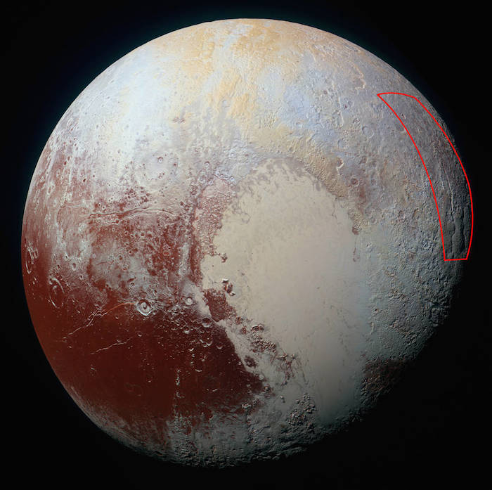
Location of the spider-like feature at the eastern edge of Pluto's encounter hemisphere, as captured by NASA’s New Horizons spacecraft on July 14, 2015.
Quelle: NASA
.
Update: 17.04.2016
.
Pluto’s Haze Varies in Brightness
Scientists on NASA’s New Horizons mission team are learning more about the structure and behavior of Pluto’s complex atmosphere by discovering new attributes of its extensive haze layers. The hazes were first discovered by New Horizons in July, as the spacecraft swept past Pluto and made its historic first exploration of the mysterious world.
.
Mission scientists have discovered that the layers of haze in Pluto’s nitrogen atmosphere vary in brightness depending on illumination and viewpoint, yet the haze itself maintains its overall vertical structure. The brightness variations may be due to buoyancy waves – what atmospheric scientists also call gravity waves – which are typically launched by the flow of air over mountain ranges. Atmospheric gravity waves are known to occur on Earth, Mars and now, likely, Pluto as well.
Pluto’s haze layers are best seen in images taken by NASA’s New Horizons spacecraft with the sun behind Pluto. New Horizons obtained a series of these backlit images as it departed from Pluto on July 14, 2015. In these observations, from New Horizons’ Long Range Reconnaissance Imager (LORRI), the haze layers over particular geographic locations on Pluto were imaged several times, at time intervals of 2 to just over 5 hours. The brightness in the layers varied by about 30 percent, though the height of the layers above the surface remained the same.
“Pluto is simply amazing,” said Andy Cheng, LORRI principal investigator from the Johns Hopkins University Applied Physics Laboratory in Laurel, Maryland. “When I first saw these images and the haze structures that they reveal, I knew we had a new clue to the nature of Pluto’s hazes. The fact that we don’t see the haze layers moving up or down will be important to future modelling efforts.”
Quelle: NASA
---
Mapping to Make Sense of Pluto
.
Today’s blog post is from Oliver White, a postdoctoral researcher in planetary science at NASA Ames Research Center in Mountain View, California. He studies the geomorphology and surface processes of planetary bodies in the outer solar system.
Looking at the surface of a planet or moon for the first time can be bewildering, particularly when confronted by a variety of terrains and landforms. This is certainly what NASA’s New Horizons team felt when we received the first close-up pictures of Pluto after the flyby in July 2015. None of us were expecting to see such a diverse range of landforms like mountains and glaciers of exotic ice on such a small, cold and distant world.
After flyby our challenge was to piece together the geological history of Pluto’s surface—that is, to determine what processes have formed and modified each terrain, and when these processes occurred relative to one another.
In order to accomplish this, planetary scientists create geological maps of the surfaces of distant bodies. The New Horizons spacecraft flew past Pluto at a range of several thousand miles/kilometers. As such, creating a geological map of a planetary surface like Pluto’s is more challenging than creating a map for one on Earth. Of course, we’re unable to walk around on Pluto and pick up samples in order to analyze what they are and how they have been processed. Instead, we must rely entirely on spacecraft images and other remote sensing data to create a Pluto map. For example, compositional data provided by the Ralph/Multispectral Visible Imaging Camera (MVIC) and the Linear Etalon Imaging Spectral Array (LEISA) are extremely useful for mapping Pluto. Knowing the composition of a unit helps constrain what physical properties it has and, therefore, how it likely formed and was modified over time. The compositional data are the closest we have to possessing an ice sample from each of the different terrains on Pluto.
.
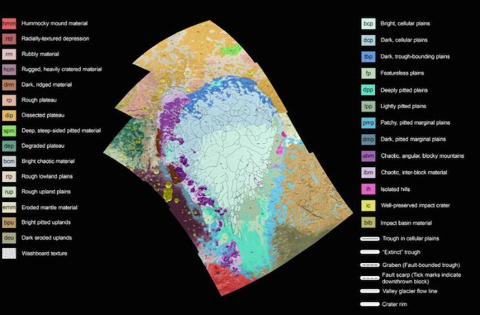
Geological map of the informally named Sputnik Planum and surrounding terrain on Pluto. Click on the map for a larger version. See image below for scale bar. Credits: NASA/JHUAPL/SwRI/Oliver White
-
The colored map shown above is just such a map that I have created for the region of the encounter hemisphere on Pluto that covers the huge nitrogen ice plains informally named Sputnik Planum and the terrain immediately surrounding it. The map shows New Horizons imagery of this area, overlaid with colors that represent different geological terrains, or units. The black and white image below shows the New Horizons imagery, along with latitude and longitude lines and a scale bar.
.
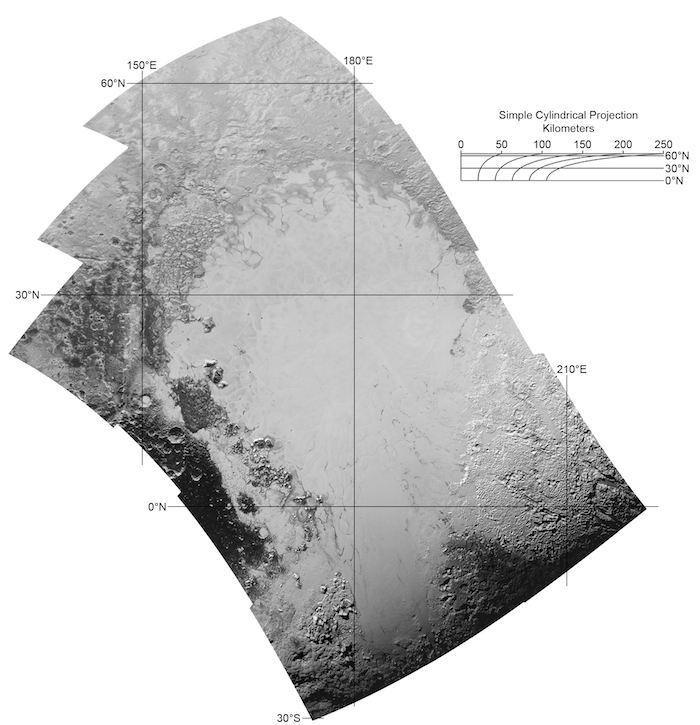
Mosaic of 12 New Horizons images obtained by the Long-Range Reconnaissance Imager on New Horizons at a resolution of 1280 feet (390 meters) per pixel, which was used as the mapping area. Credits: NASA/JHUAPL/SwRI/Oliver White
-
I have studied this area in great detail, and have defined each unit based on its texture and morphology—for example, whether it is smooth, pitted, craggy, hummocky or ridged. How well a unit can be defined depends on the resolution of the images that cover it. All of the terrain in my map has been imaged at a resolution of approximately 1,050 feet (320 meters) per pixel or better, meaning textures are resolved such that I can map units in this area with relative confidence.
By studying how the boundaries between units crosscut one another, I can also determine which units overlie others, and assemble a relative chronology (or timeline) for the different units; this work is aided by crater counts for the different terrains that have been obtained by other team members. I caution that owing to the complexity of the surface of Pluto, the work I’ve shown is in its early stages, and a lot more is still to be done.
My mapping project, which began only a few days after the flyby, is currently expanding across the rest of Pluto’s encounter hemisphere. Mapping a place as interesting as Pluto has been a highly engaging, thought-provoking and fun experience. When I was an undergraduate studying planetary science, filling in my first planetary geological map of a region on Mars with coloring pencils, I never imagined that a decade later I would be making the first geological map of this world that had been a tantalizing enigma for so long!
.

Oliver White with a model of the New Horizons spacecraft.
Quelle: NASA
-
Update: 21.04.2016
.
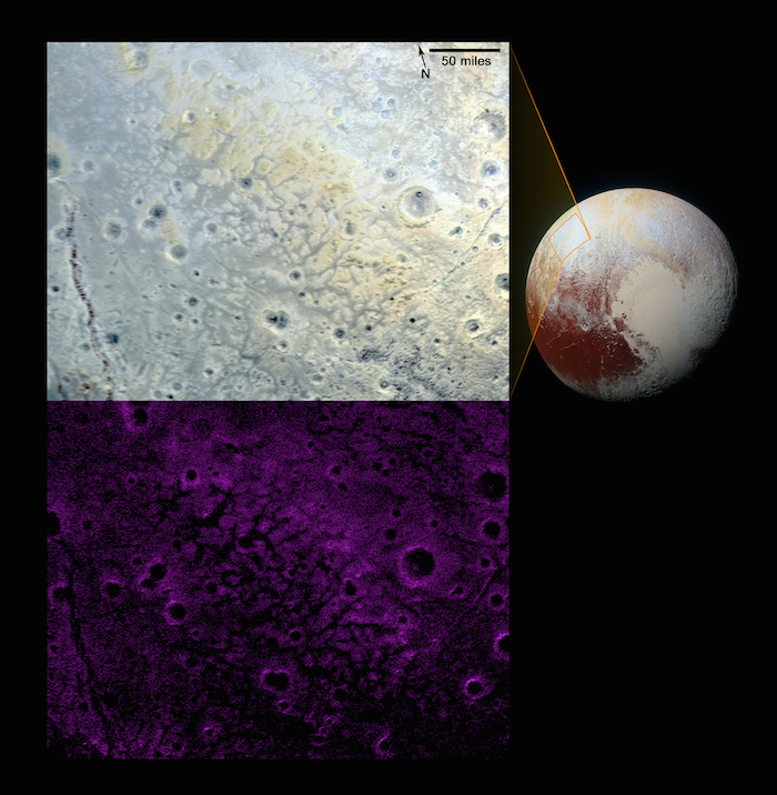
Pluto’s ‘Halo’ Craters
Within Pluto’s informally named Vega Terra region is a field of eye-catching craters that looks like a cluster of bright halos scattered across a dark landscape.
.
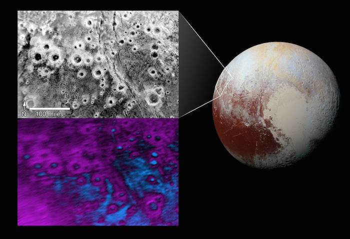
The region is far west of the hemisphere NASA’s New Horizons spacecraft viewed during close approach last summer. The upper image – in black and white – sports several dozen “haloed” craters. The largest crater, at bottom-right, measures about 30 miles (50 kilometers) across. The craters’ bright walls and rims stand out from their dark floors and surrounding terrain, creating the halo effect.
In the lower image, composition data from New Horizons’ Ralph/Linear Etalon Imaging Spectral Array (LEISA) indicate a connection between the bright halos and distribution of methane ice, shown in false color as purple. The floors and terrain between craters show signs of water ice, colored in blue. Exactly why the bright methane ice settles on these crater rims and walls is a mystery; also puzzling is why this same effect doesn’t occur broadly across Pluto.
The upper view is a mosaic made from two separate images obtained by New Horizons’ Long Range Reconnaissance Imager (LORRI). A high-resolution strip taken at approximately 760 feet (232 meters) per pixel is overlain on a broader, low-resolution image taken at 2,910 feet (889 meters) per pixel. The images were obtained at ranges of 28,800 miles (46,400 kilometers) and 106,700 miles (171,700 kilometers) from Pluto, respectively, on July 14, 2015. The LEISA data came the same day, during the instrument’s highest-resolution scan of Pluto, with New Horizons 28,000 miles (45,500 kilometers) from Pluto, with a resolution of 1.7 miles (2.7 kilometers) per pixel.
Quelle: NASA
-
Update: 30.04.2016
.
New Elevation Map of Pluto’s Sunken ‘Heart’
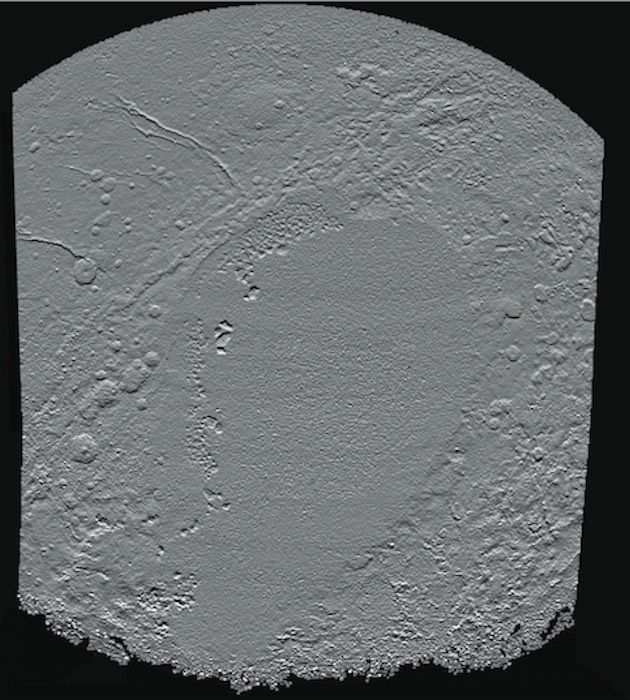
This newest shaded relief view of the region surrounding the left side of Pluto’s heart-shaped feature – informally named Sputnik Planum – shows that the vast expanse of the icy surface is on average 2 miles (3 kilometers) lower than the surrounding terrain. Angular blocks of water ice along the western edge of Sputnik Planum can be seen “floating” in the bright deposits of softer, denser solid nitrogen.
Topographic maps of Pluto are produced from digital analysis of New Horizons stereo images acquired during the July 14, 2015 flyby. Such maps are derived from digital stereo-image mapping tools that measure the parallax – or the difference in the apparent relative positions – of individual features on the surface obtained at different times. Parallax displacements of high and low features are then used to directly estimate feature heights.
These topographic maps are works in progress and artifacts are still present in the current version. The map is artificially illuminated from the south, rather than the generally northern solar lighting of landscape during the time of the flyby. One of the many advantages of digital terrain maps is that they can be illuminated from any direction to best bring out different features. North is up and the total relief in the scene is approximately 4 miles (6 kilometers) from the lowest to the highest features.
.
Pluto: A Global Perspective
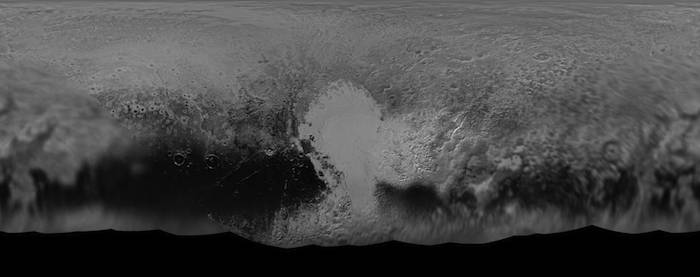
NASA’s New Horizons mission science team has produced this updated panchromatic (black-and-white) global map of Pluto. The map includes all resolved images of Pluto’s surface acquired between July 7-14, 2015, at pixel resolutions ranging from 18 miles (30 kilometers) on the Charon-facing hemisphere (left and right edges of the map) to 770 feet (235 meters) on the hemisphere facing New Horizons during the spacecraft’s closest approach on July 14, 2015 (map center). The non-encounter hemisphere was seen from much greater range and is, therefore, in far less detail.
The latest images woven into the map were sent back to Earth as recently as April 25, and the team will continue to add photos as the spacecraft transmits the rest of its stored Pluto encounter data. All encounter imagery is expected on Earth by early fall. The team is also working on improved color maps.
Quelle: NASA/JHUAPL/SWRI
-
Update: 4.05.2016
.
Pluto’s Interaction with the Solar Wind is Unique, Study Finds
Four images from New Horizons’ Long Range Reconnaissance Imager (LORRI) were combined with color data from the Ralph instrument to create this global view of Pluto. The images, taken when the spacecraft was 280,000 miles (450,000 kilometers) away from Pluto, show features as small as 1.4 miles (2.2 kilometers).
Credits: NASA/JHUAPL/SwRI
-
Pluto behaves less like a comet than expected and somewhat more like a planet like Mars or Venus in the way it interacts with the solar wind, a continuous stream of charged particles from the sun.
This is according to the first analysis of Pluto’s interaction with the solar wind, funded by NASA’s New Horizons mission and published today in the Journal of Geophysical Research – Space Physics by the American Geophysical Union (AGU).
Using data from the Solar Wind Around Pluto (SWAP) instrument from the New Horizons July 2015 flyby, scientists have for the first time observed the material coming off of Pluto’s atmosphere and studied how it interacts with the solar wind, leading to yet another “Pluto surprise.”
“This is a type of interaction we’ve never seen before anywhere in our solar system,” said David J. McComas, lead author of the study. McComas, professor of astrophysical sciences at Princeton University and vice president for the Princeton Plasma Physics Laboratory. “The results are astonishing.” McComas leads the SWAP instrument aboard New Horizons; he also led the development of SWAP when he was at the Southwest Research Institute (SwRI) in San Antonio, Texas.
Space physicists say that they now have a treasure trove of information about how Pluto’s atmosphere interacts with the solar wind. Solar wind is the plasma that spews from the sun into the solar system at a supersonic 100 million miles per hour (160 million kilometers per hour), bathing planets, asteroids, comets and interplanetary space in a soup of mostly protons and electrons.
Previously, most researchers thought that Pluto was characterized more like a comet, which has a large region of gentle slowing of the solar wind, as opposed to the abrupt diversion solar wind encounters at a planet like Mars or Venus. Instead, like a car that’s part gas- and part battery-powered, Pluto is a hybrid, researchers say.
So Pluto continues to confound. “These results speak to the power of exploration. Once again we’ve gone to a new kind of place and found ourselves discovering entirely new kinds of expressions in nature,” said SwRI’s Alan Stern, New Horizons principal investigator.
Since it’s so far from the sun – an average of about 3.7 billion miles, the farthest planet in the solar system – and because it’s the smallest, scientists thought Pluto’s gravity would not be strong enough to hold heavy ions in its extended atmosphere. But, “Pluto’s gravity clearly is enough to keep material relatively confined,” McComas said.
The researchers were able to separate the heavy ions of methane, the main gas escaping from Pluto’s atmosphere, from the light ions of hydrogen that come from the sun using the SWAP instrument.
Among additional Pluto findings:
Like Earth, Pluto has a long ion tail, that extends downwind at least a distance of about 100 Pluto radii (73,800 miles/118,700 kilometers, almost three times the circumference of Earth), loaded with heavy ions from the atmosphere and with “considerable structure.”
Pluto’s obstruction of the solar wind upwind of the planet is smaller than had been thought. The solar wind isn’t blocked until about the distance of a couple planetary radii (1,844 miles/3,000 kilometers, about the distance between Chicago and Los Angeles.)
Pluto has a very thin boundary of Pluto’s tail of heavy ions and the sheath of the shocked solar wind that presents an obstacle to its flow.
Heather Elliott, astrophysicist at SwRI and co-author on the paper, notes, “Comparing the solar wind-Pluto interaction to the solar wind-interaction for other planets and bodies is interesting because the physical conditions are different for each, and the dominant physical processes depend on those conditions.”
These findings offer clues to the magnetized plasmas that one might find around other stars, said McComas. “The range of interaction with the solar wind is quite diverse, and this gives some comparison to help us better understand the connections in our solar system and beyond.”
Quelle: NASA
-
Update: 6.05.2016
.
Pluto’s Icy Moon Hydra
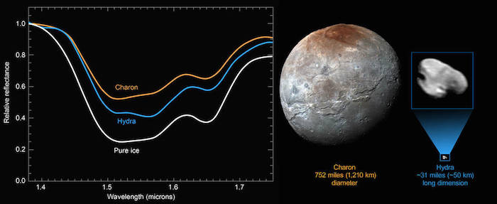
New compositional data from NASA’s New Horizons spacecraft reveal a distinct water-ice signature on the surface of Pluto’s outermost moon, Hydra. Pluto’s largest moon Charon measures 752 miles (1,210 kilometers across), while Hydra is approximately 31 miles (50 kilometers) long.
Credits: NASA/JHUAPL/SwRI
-
NASA’s New Horizons spacecraft has sent home the first compositional data about Pluto's four small satellites. The new data show the surface of Hydra, Pluto’s outermost small moon, is dominated by nearly pristine water ice – confirming hints that scientists picked up in New Horizons images showing Hydra’s highly reflective surface.
The new compositional data, recently received on Earth, was gathered with the Ralph/Linear Etalon Imaging Spectral Array (LEISA) instrument on July 14, 2015, from a distance of 150,000 miles (240,000 kilometers).
The new data – known as infrared spectra – show the unmistakable signature of crystalline water ice: a broad absorption from 1.50 to 1.60 microns and a narrower water-ice spectral feature at 1.65 microns. The Hydra spectrum is similar to that of Pluto’s largest moon, Charon, which is also dominated by crystalline water ice. But Hydra’s water-ice absorption bands are even deeper than Charon’s, suggesting that ice grains on Hydra’s surface are larger or reflect more light at certain angles than the grains on Charon. Hydra is thought to have formed in an icy debris disk produced when water-rich mantles were stripped from the two bodies that collided to form the Pluto-Charon binary some 4 billion years ago. Hydra’s deep water bands and high reflectance imply relatively little contamination by darker material that has accumulated on Charon's surface over time.
Mission scientists are investigating why Hydra’s ice seems to be cleaner than Charon’s. "Perhaps micrometeorite impacts continually refresh the surface of Hydra by blasting off contaminants,” said Simon Porter, a New Horizons science team member from Southwest Research Institute in Boulder, Colorado, “This process would have been ineffective on the much larger Charon, whose much stronger gravity retains any debris created by these impacts.”
The New Horizons science team is looking forward to obtaining similar spectra of Pluto’s other small moons, for comparison to Hydra and Charon.
.
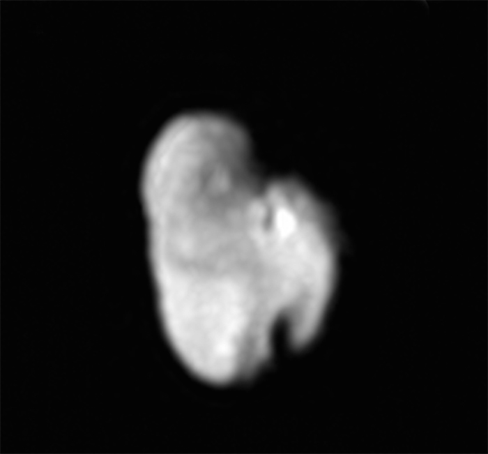
Pluto’s outermost moon, Hydra
Credits: Credits: NASA/JHUAPL/SwRI
Quelle: NASA
-
Update: 18.05.2016
.
Scientists on NASA’s New Horizons team say the spacecraft succeeded in observing the first occultations of Pluto’s atmosphere by ultraviolet stars, an important goal of the mission’s Pluto encounter. These data, stored on New Horizons’ digital recorders since last summer’s encounter and recently transmitted to Earth, confirm several major findings about Pluto’s atmosphere.
Approximately four hours after New Horizons made its closest approach to Pluto on July 14 – when the spacecraft was about 200,000 miles (320,000 kilometers) beyond Pluto – the Alice ultraviolet spectrometer instrument on board the spacecraft “watched” as two bright ultraviolet stars passed behind Pluto and its atmosphere. The light from each star dimmed as it moved through deeper layers of Pluto’s atmosphere, absorbed by various gases and hazes.
Much like the solar occultation that Alice had observed a few hours before – when it used sunlight to make similar measurements – these stellar occultations provided information about the composition and structure of Pluto's atmosphere. Both stellar occultations revealed ultraviolet spectral fingerprints of nitrogen, hydrocarbons like methane and acetylene, and even haze, just as the solar occultation had done earlier.
The results from the solar and stellar occultations are also consistent in terms of vertical pressure and temperature structure of Pluto’s upper atmosphere. This means that the upper atmosphere vertical profiles of nitrogen, methane, and the observed hydrocarbons are similar over many locations on Pluto.
These results confirm findings from the Alice solar occultation, that the upper atmospheric temperature is as much as 25 percent colder and thus more compact than what scientists predicted before New Horizons’ encounter. This also confirms, albeit indirectly, the result from analysis and modeling of the Alice solar observation that the escape rate of nitrogen is about 1,000 times lower than expected before the flyby.
.
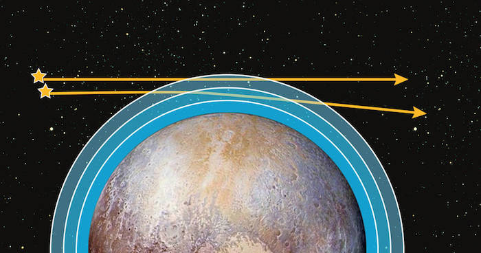
This illustration shows how New Horizons’ Alice ultraviolet spectrometer instrument “watched” as two bright ultraviolet stars passed behind Pluto and its atmosphere. The light from each star dimmed as it moved through deeper layers of the atmosphere, absorbed by various gases and hazes.
Credits: NASA/JHUAPL/SWRI
Quelle: NASA
.
Update: 22.05.2016
.
Pluto’s ‘Fretted’ Terrain
In looking over images of Pluto’s informally named Venera Terra region, New Horizons scientists have spotted an expanse of terrain they describe as “fretted.” As shown in the enhanced-color image at top, this terrain consists of bright plains divided into polygon-shaped blocks by a network of dark, connected valleys typically reaching a few miles (3 to 4 kilometers) wide. Numerous impact craters of up to 15 miles (25 kilometers) in diameter also dot the area, implying the surface formed early in Pluto’s history.
New Horizons scientists haven’t seen this type of terrain anywhere else on Pluto; in fact, it’s rare terrain across the solar system – the only other well-known example of such being Noctis Labyrinthus on Mars. The distinct interconnected valley network was likely formed by extensional fracturing of Pluto’s surface. The valleys separating the blocks may then have been widened by movement of nitrogen ice glaciers, or flowing liquids, or possibly by ice sublimation at the block margins. Compositional data from New Horizons’ Ralph/Multispectral Visible Imaging Camera (MVIC), shown in the bottom image, indicate that the blocks are rich in methane ice (shown as false-color purple); methane is susceptible to sublimation at Pluto surface conditions.
The resolution of these MVIC images is approximately 2,230 feet (680 meters) per pixel. They were obtained at a range of approximately 21,100 miles (33,900 kilometers) from Pluto, about 45 minutes before New Horizons’ closest approach on July 14, 2015.
Quelle: NASA
.
Update: 25.05.2016
.
Close encounters of a tidal kind could lead to cracks on icy moons
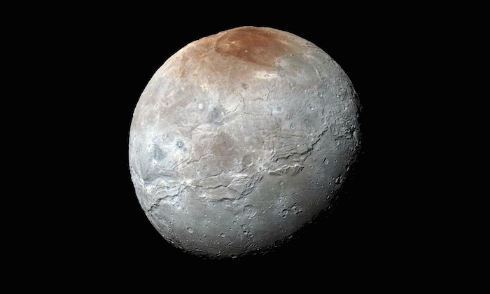
NASA's New Horizons captured this high-resolution enhanced color view of Pluto's moon Charon, showing the crack on the icy moon. It was taken just before closest approach on July 14, 2015. The image combines blue, red and infrared images and the colors are processed to best highlight the variation of surface properties across Charon.
-
New model could offer an explanation for cracks like the one on Charon
A new model developed by University of Rochester researchers could offer a new explanation as to how cracks on icy moons, such as Pluto’s Charon, formed.
Until now, it was thought that the cracks were the result of geodynamical processes, such as plate tectonics, but the models run by Alice Quillen and her collaborators suggest that a close encounter with another body might have been the cause.
Astronomers have long known that the craters visible on moons were caused by the impact of other bodies, billions of years ago. But for every crash and graze, there would have been many more close encounters. By devising and running a new computer model, Quillen, a professor of physics and astronomy at Rochester, has now shown that the tidal pull exerted by another, similar object could be strong enough to crack the surface of such icy moons. Quillen also thinks that “it might even offer a possible explanation for the crack on Mars, but that’s much harder to model.”
Icy moons exhibit what is know as brittle elastic behavior, which Quillen says most resembles “silly putty.”
“If you take silly putty and throw it on the floor it bounces – that’s the elastic part,” said Quillen. “But if you pull on it rapidly and hard enough, it breaks apart.”
To simulate the behavior, Quillen modeled the icy moons as if their interior was made up of many bodies connected by springs (an N-body problem with springs). While N-body problems are often used to understand the effect of gravity on planets and stars, N-body problems had never been used to model the inside of an astronomical body, in this case the moons. Other models for icy moons used what are known as “rubble pile models.”
“I was inspired by computer graphics code in how to model the icy moons,” said Quillen. “The inside of the moons is similar to how blood splatter is modeled in games and the outer, icy crust is similar to modeling clothes and how they move. But I, of course, had to ensure the code matched the underlying physics!”
To ensure her model took into account the right properties for the materials that make up the moons, she worked with earth sciences Professor Cynthia Ebinger.
“I jumped at the opportunity to consider a novel alternative to plate tectonics, the governing theory to explain earthquakes, volcanoes and moving plates on Earth,” said Ebinger. “My role was to provide some checks and balances to Alice’s modeling and the choice of model parameters.”
In the paper, to be published by the journal Icarus, Quillen states that “strong tidal encounters” may be responsible for the cracks on icy moons such as Charon, Saturn’s Dione and Tethys, and Uranus’ Ariel.
The key factor in determining if a crack is going to occur is the strain rate, the rate of pull from another body that would have caused the moons to deform at a rate that the top, icy layer could not sustain – leading to cracks.
Quillen’s and Ebinger’s co-authors on the paper are David Giannella and John G. Shaw, also at the University of Rochester.
In a companion paper, published in Monthly Notices of the Royal Astronomical Society, Quillen has shown that her models are consistent with the rate at which moons spin up or down when orbiting another object.”
The work was in part supported by NASA grant NNX13AI27G.
Quelle: University of Rochester
5423 Views