3.04.2019

For a good portion of these satellites, it’s possible that they have experienced some kind of technical problem, preventing the operators from contacting the spacecraft in orbit. But part of the identification issue stems from the SSO-A mission’s structure. This was a rocket ride-share, a type of launch that’s become popular in the industry. As satellites grow smaller, operators can pack a bunch of these tiny probes together on larger launch vehicles, sending them into space all at once. But with so many satellites going into orbit at the same time, it can be hard for the Air Force’s technology to distinguish the satellites from each other. And that, in turn, can make it hard for satellite operators to decipher which satellites are theirs.
“When you have objects that are in a cluster, so to speak, it’s very difficult to disambiguate which one is which exactly,” Moriba Jah, a professor of aerospace engineering at the University of Texas who specializes in space tracking and oversees a tracking site called AstriaGraph, tells The Verge.
Not knowing the exact location of a spacecraft is a major problem for operators. If they can’t communicate with their satellite, the company’s orbiting hardware becomes, essentially, space junk. It brings up liability and transparency concerns, too. If an unidentified satellite runs into something else in space, it’s hard to know who is to blame, making space less safe — and less understood — for everyone. That’s why analysts and space trackers say both technical and regulatory changes need to be made to our current tracking system so that we know who owns every satellite that’s speeding around the Earth. “The whole way we do things is just no longer up to the task,” Jonathan McDowell, an astrophysicist at Harvard and spaceflight tracker, tells The Verge.
HOW TO IDENTIFY A SATELLITE
Up until recently, figuring out a satellite’s identity has been relatively straightforward. The Air Force has satellites high above the Earth that detect the heat of rocket engines igniting on the ground, indicating when a vehicle has taken off. It’s a system that was originally put in place to locate the launch of a potential missile, but it’s also worked well for spotting rockets launching to orbit. And for most of spaceflight history, usually just one large satellite or spacecraft has gone up on a launch — simplifying the identification process.
“For more traditional launches, where there are fewer objects, it’s fairly simple to do,” Diana McKissock, the lead for space situational awareness sharing and spaceflight safety at the Air Force’s 18th Space Control Squadron, tells The Verge. As a result, the Air Force has maintained a robust catalog of more than 20,000 space objects in orbit, many of which have been identified.

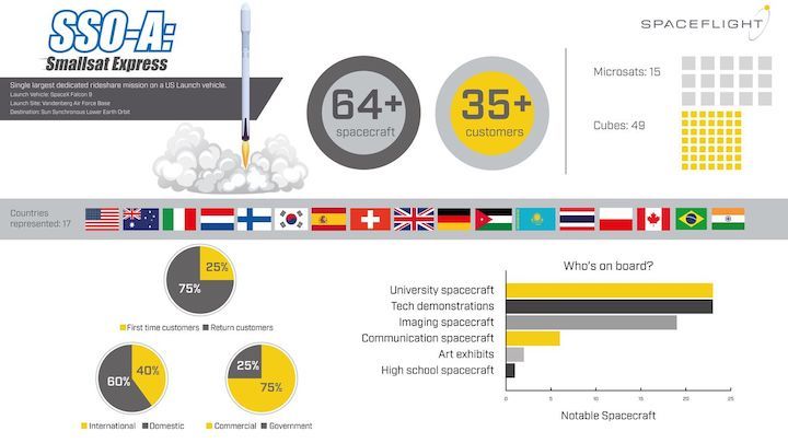
But as rocket ride-shares have grown in popularity, the Air Force’s surveillance capabilities have sometimes struggled to identify every satellite that is deployed during a launch. One problem is that most of the spacecraft on board all look the same. Nearly 50 satellites on the SSO-A launch were modified CubeSats — a type of standardized satellite that’s roughly the size of a cereal box. That means they are all about the same size and have the same general boxy shape. Plus, these tiny satellites are often deployed relatively close together on ride-share launches, one right after the other. The result is a big swarm of nearly identical spacecraft that are difficult to tell apart from the ground below.
Operators often rely on tracking data from the Air Force to find their satellites, so if the military cannot tell a significant fraction of these CubeSats apart, the operators don’t know where to point their ground communication equipment to get in contact with their spacecraft.
It’s a bit of a Catch-22, though. The Air Force also relies on satellite operators to help identify their spacecraft. Before a launch, the Air Force collects information from satellite operators about the design of the spacecraft and where it’s going to go. The operators are also responsible for making sure that they have the proper equipment (in space and on the ground) to communicate with the satellite. “It’s really a cooperative, ongoing process that involves the satellite operators as much as it involves us here at the 18th, processing the data,” says McKissock.
THE STRUGGLES OF THE SSO-A OPERATORS
Technical glitches seem to be plaguing at least some of the lost satellites from the SSO-A launch, such as Audacy Zero — a communications CubeSat launched by the company Audacy. “There are still a couple of communication methods we are exploring, but it is looking likely at this point that we have a technical anomaly on the satellite,” Amanda Chia, head of business development at Audacy, tells The Verge.
Another complication to Audacy’s communication efforts is that the company still doesn’t know where their satellite is. Ralph Ewig, Audacy’s CEO, says his team has narrowed it down to five satellites from the launch, but they still aren’t certain which one is theirs. “Having been on the launch of that many other satellites made our diagnostics and troubleshooting a whole lot more difficult than we had originally anticipated,” Ewig tells The Verge.
For some operators, it seems that they were able to get in touch with their satellite at the beginning of the flight when all the satellites were in one big blob and close together in space. But as the probes have spread apart in the last few months, it’s become more difficult to know where to point their communication equipment, since so many identities are still unknown. Some operators have had trouble hearing back from the satellites in recent months.
That seems to be the case for Trevor Paglen’s Orbital Reflector — an art project that’s supposed to deploy a giant reflective balloon capable of being seen from Earth. In January, the team behind the satellite said that they had been in contact with the spacecraft, but that the government shutdown had impacted their ability to deploy the balloon. The website for the project states that the team still doesn’t have accurate orbital data for the satellite. “We are working to resolve these issues and will have more conclusive information to share in the near future,” Amanda Horn, a representative for the Nevada Museum of Art, said in a statement to The Verge.
And sometimes, time is of the essence for operators. A satellite may need more immediate communication in order to work properly; perhaps the vehicle needs to be told to orient itself in such a way to keep its batteries charged. “Depending on the design, some satellites, you might not contact them for two years and then you contact them and they’re fine,” says McDowell, who provided detailed tracking information about SSO-A to The Verge. “And other satellites, not so much.”
WHERE DID SSO-A GO WRONG?
The SSO-A launch isn’t the only example of mistaken satellite identity. Five satellites are still unidentified from an Electron launch that took place in December last year, which sent up 13 objects, according to McDowell. And in 2017, a Russian Soyuz rocket deployed a total of 72 satellites, but eight are still unknown, says McDowell. The SSO-A launch is perhaps the most egregious example of this ride-share problem, as nearly a third of the satellites are still missing in the Air Force’s catalog.
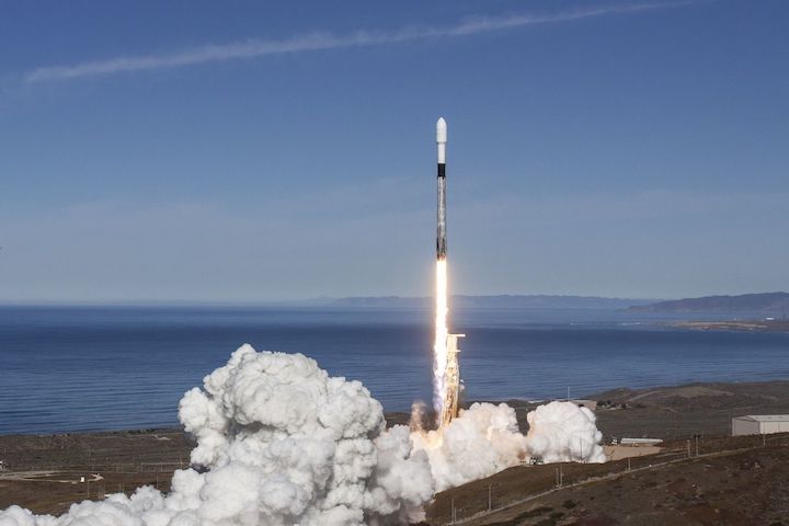
The Air Force says the launch posed a unique challenge. One difficulty had to do with the way the satellites were deployed, according to McKissock, who says it was hard to predict before the launch where each satellite was going to be. The SSO-A launch was organized by a company called Spaceflight Industries, which acts as a broker for operators — finding room for their satellites on upcoming rocket launches. Spaceflight bought this entire Falcon 9 rocket for the SSO-A launch, and created the device that deployed all of these satellites into orbit. One satellite tracker, T.S. Kelso, who operates a tracking site called CelesTrak, agreed with the Air Force, saying that Spaceflight’s deployment platform made it hard to predict each satellite’s exact position. “[Spaceflight] had no way to provide the type of data needed,” Kelso writes in an email to The Verge.

Another hurdle revolved around the diversity of operators launching on SSO-A. Other launches have sent up even more satellites than the SSO-A mission did, but often the satellites primarily come from one operator. SSO-A boasted a wide range of operators, many of which were newcomers to spaceflight, and the Air Force had the complex task of getting necessary orbital information from each group on the flight. “There were so many different owner operators from 15 different countries, many of whom we hadn’t worked with before,” McKissock says. “That was a unique challenge — harnessing all of that information in an effective way.”
And in the end, the Air Force is sometimes at the mercy of the operators’ information. It’s possible that some of the owners of the unidentified satellite got in touch with their vehicles recently and just have not informed the Air Force where they are. “A lot of what we do is based on the information they provide, but that’s all we can do,” says McKissock. “So if an operator doesn’t want to support the identification process, they don’t have to.” In fact, Kelso, the satellite tracker, says he was able to identify an additional seven satellites of the 19 unidentified ones, by working with the satellite operators. “That suggests 18 SPCS is either not receiving the same reports or discounting them for whatever reason,” he writes.
The Air Force’s 18th Space Control Squadron has other priorities to consider, too. While identifying spacecraft is something the team always hopes to accomplish on every flight, the main function of the 18th is to track as many objects as possible and then provide information on the possibility of spacecraft running into each other in orbit. The identification of satellites is secondary to that safety concern. “I wouldn’t say it’s not a priority, but we certainly have other mission requirements to consider,” says McKissock.
HOW DO WE FIX THIS?
For now, not knowing the identities of all the SSO-A satellites is mostly an inconvenience to the operators that aren’t able to get the full benefits of their satellites. Additionally, if these CubeSats did pose a threat to any nearby spacecraft, there isn’t much that could be done — even if we knew all the vehicles’ owners. CubeSats are too small to have any thrusters, so they wouldn’t be able to move out of the way of an imminent collision.
But there are still safety concerns with unidentified satellites, especially if we cannot identify probes from other countries that pose a threat to US satellites. “If you’re talking about safety, what you really care about is: Where is it? And who do I call if it’s coming close to my satellite?” says Brian Weeden, director of program planning at the Secure World Foundation focusing on space operations and policy, tells The Verge. That way, if another country’s spacecraft is getting close to, say, the International Space Station, the US knows who to contact to get it moved out of the way.
The SSO-A flight also demonstrates an issue that has plagued space tracking for decades: the ambiguity of what’s happening up above Earth. If a satellite breaks apart in orbit, for instance, sometimes we know why — and sometimes we don’t. Establishing causality in space, with numerous unidentified satellites around the planet, is even more complicated. “When something happens in space, there are multiple things that could have caused it, and they’re equally unknown,” says Jah. “And that’s a problem. We’d love to get to the point where when something happens, you could say, ‘This happened because of this,’ with near absolute certainty.”
The best way to get to that future is to identify everything. And one thing most experts agree on is that the Air Force should be able to name satellites without requiring input from anyone else. “The best case scenario is if the object can be tracked, independent of the owner operator,” says Jah. One idea is to have all operators add uniquely identifiable features to their satellites, something akin to an RFID tag or a license plate that can be read from Earth. Such a regulatory change could come about thanks to Space Policy Directive-3, signed on June 18th, 2018, which focuses on creating guidelines and best practices to help the US figure out what is going on in space at all times.
The problem is this would only work for the US spaceflight industry. There’s no way to force other nations to put license plates on their satellites. The United Nations came up with a set of best practices in 2018 that describes ways in which countries can make their satellites easier to track, except there is no way to strictly enforce these measures. There have already been numerous Chinese launches, for instance, in which multiple satellites have launched on one rocket and the Air Force has been unable to identify some of the probes.
That’s why some argue that the Air Force should improve its identification abilities by turning to the private sector. “There are a lot more potential sources of data that could be leveraged, in addition to the traditional military owned and operated radars and telescopes,” says Weeden. Companies like AGI, LeoLabs, and more are developing new algorithms, radar, and telescopes that the Air Force could use for tracking and identification. In fact, some of these companies helped a few of the satellite operators on SSO-A, such as Audacy, attempt to track down their satellites.
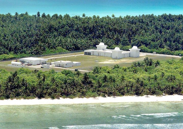
Having better technology options may be helpful, since the Air Force will soon be tracking more objects in space than ever before. Soon, the military will activate what is known as the “space fence,” a new radar system located on an island called the Kwajalein Atoll in the Pacific. It’ll be able to track even smaller objects, which could be difficult for the 18th Space Control Squadron to process. “They’re suggesting anywhere between 100,000 to 200,000 new objects that have never been tracked before that are going to get added to the catalog,” says Weeden. “And their existing computer systems at the 18th just can’t deal with that.”
The Air Force acknowledges that processing the new data will require a lot of extra work. “We are fully aware the exponential increase in... data will make an already complex process more challenging,” Major Cody Chiles, a spokesperson for the Air Force’s Joint Force Space Component Command, said in a statement. “We are preparing for this challenge by actively working with our commercial, interagency, and military partners to identify ways to effectively and efficiently manage the influx of data.”
Adding to the problem is that thousands of new satellites are set to be launched in the years to come, thanks to companies like SpaceX, OneWeb, and more looking to beam internet from space. Earth orbit is going to get crowded, increasing the need for clarity and identification. That means something needs to change soon before the amount of satellites in space quadruples — and we’re faced with the possibility of even more unidentified objects flying around our planet.
Quelle: The Verge
