-
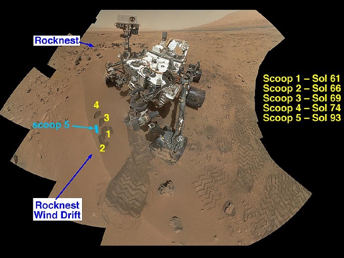
Curiosity's 'Rocknest' Workplace
NASA's Curiosity Mars rover documented itself in the context of its work site, an area called "Rocknest Wind Drift," on the 84th Martian day, or sol, of its mission (Oct. 31, 2012). The rover worked at this location from Sol 56 (Oct. 2, 2012) to Sol 100 (Nov. 16, 2012).
The drift consists of sand trapped on the downwind side of a group of dark cobbles the team named Rocknest. This mosaic of 55 images from the Mars Hand Lens Imager (MAHLI) shows the first four of five places from which the rover’s scoop obtained sand to clean the sample handling and processing system. The scooped material was ultimately delivered to the Chemistry and Mineralogy Experiment (CheMin) and the Sample Analysis at Mars (SAM) laboratory instruments housed inside the rover’s body. The annotated version of this figure shows the location of a scoop taken at a later date -- the fifth and final scoop, and the only one that provided grains delivered to SAM.
Before scooping, the rover team put an approximately 20-inch-wide (about 50- centimeter-wide) wheel print on the Rocknest wind drift. This allowed MAHLI and the Alpha Particle X-Ray Spectrometer (APXS) to determine whether the drift really consisted of sand with small enough sizes to clean the Collection and Handling for In-Situ Martian Rock Analysis (CHIMRA) instrument and be delivered to CheMin and SAM. The drift material at the center of the wheel print, named "Portage" by the rover team, was examined by the APXS.
The rover’s robotic arm is not visible in the mosaic because the MAHLI that took this mosaic is on the turret at the end of the arm. Wrist motions and turret rotations on the arm allowed MAHLI to acquire the mosaic's 55 images. An earlier version of the Sol 84 self-portrait was released Nov. 1, 2012 (see PIA16239).
Image credit: NASA/JPL-Caltech/MSSS
-
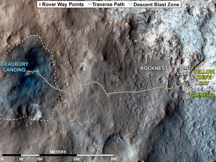
Curiosity Rover's Traverse, August through November 2012
This map shows where NASA's Mars rover Curiosity has driven since landing at a site subsequently named "Bradbury Landing," and traveling to an overlook position near beside "Point Lake," in drives totaling 1,703 feet (519 meters). The rover landed on Aug. 5 Pacific Time (Aug. 6, Universal Time). It was at the easternmost waypoint on this map on Nov. 30, 2012. It worked on scoops of soil for a few weeks at the drift of windblown sand called "Rocknest." The place called "Glenelg" is where three types of terrain meet. The depression called "Yellowknife Bay" is a potential location for selecting the first target rock for Curiosity's hammering drill.
All of these sites are within Gale Crater and north of the mountain called Mount Sharp in the middle of the crater. After using its drill in the Glenelg area, the rover's main science destination will be on the lower reaches of Mount Sharp
-
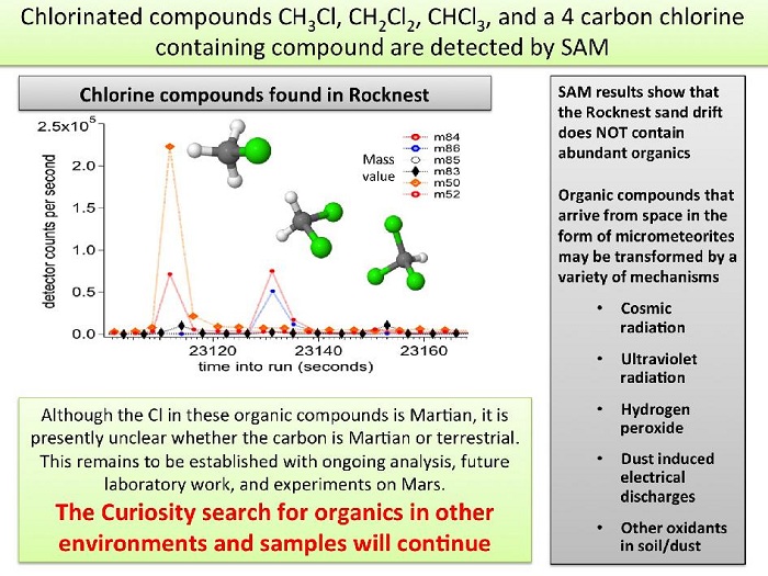
Chlorinated Compounds at 'Rocknest'
The first examinations of Martian soil by the Sample Analysis at Mars, or SAM, instrument on NASA's Mars Curiosity rover show no definitive detection of Martian organic molecules at this point. Organic molecules are carbon-containing compounds essential for life on Earth. The soil grains were acquired from a wind drift named "Rocknest."
The instrument did detect simple chlorinated carbon compounds, represented by ball and stick models on the graph. These compounds contain hydrogen and carbon as well as chlorine. More work is needed to determine if the carbon in these molecules is of terrestrial or Martian origin. The chlorinated compounds were likely created from a reaction with perchlorate or a perchlorite-like phase and carbon-containing molecules.
Future experiments will further address the question of the observed carbon's origins, and the rover will continue to search for organics in both rocks and sands in other environments of Gale Crater.
-
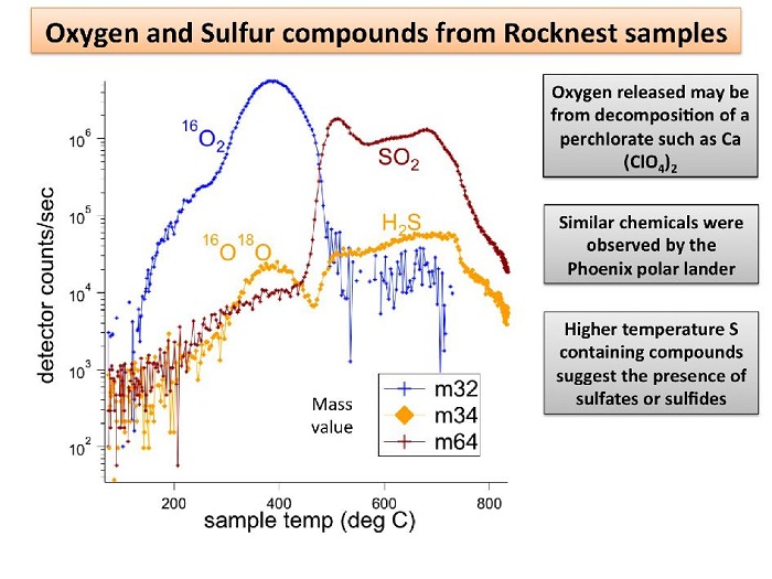
Signs of Perchlorates and Sulfur Containing Compounds
NASA's Mars rover Curiosity has detected sulfur, chlorine, and oxygen compounds in fine grains scooped by the rover at a wind drift site called "Rocknest." The grains were heated and analyzed using the rover's Sample Analysis at Mars, or SAM, instrument suite. Scientists indicate the oxygen and chlorine may come from perchlorate or similar compounds, which contain chlorine and oxygen. Perchlorates were also found by NASA's Phoenix Lander at a different location on Mars. The sulfur compounds suggest the presence of sulfides or sulfates in the grains.
-
Atmospheric Loss on Mars
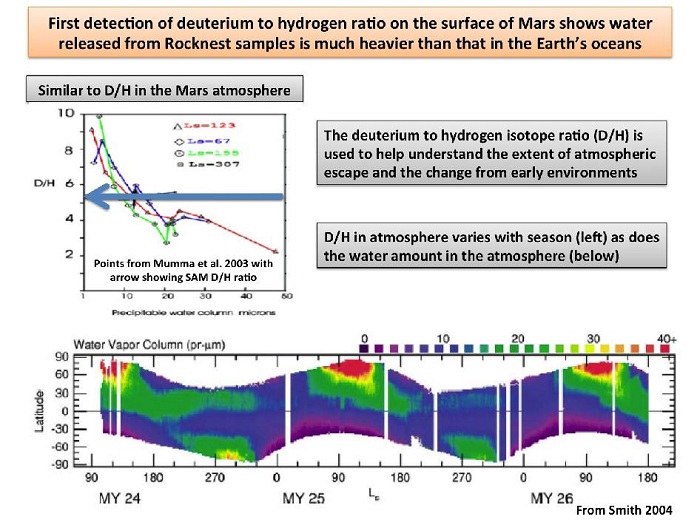
This plot shows the first-ever look at the deuterium to hydrogen ratio measured from the surface of Mars, as detected by the Sample Analysis at Mars instrument, or SAM, on NASA's Curiosity rover. Deuterium is a heavier version of the hydrogen atom. Scientists look at the deuterium to hydrogen ratios on Mars (or D/H levels) along with isotopes of other elements to study how its atmosphere has changed over time. Mars, which has less gravity than Earth and lacks a strong enough magnetic field to shield its atmosphere from the sun, is slowly losing its atmosphere. As this process occurs, the lighter hydrogen atoms are preferentially lost compared to the heavier deuterium ones.
SAM measured the D/H ratios in water released upon heating of sand samples taken from the wind drift called "Rocknest." The results show the water vapor consists of more deuterium than that of Earth's water, i.e. the water is heavier. This is to be expected since the lighter hydrogen atoms in the Martian atmosphere are escaping faster than the heavier ones.
-
Heating Martian Sand Grains
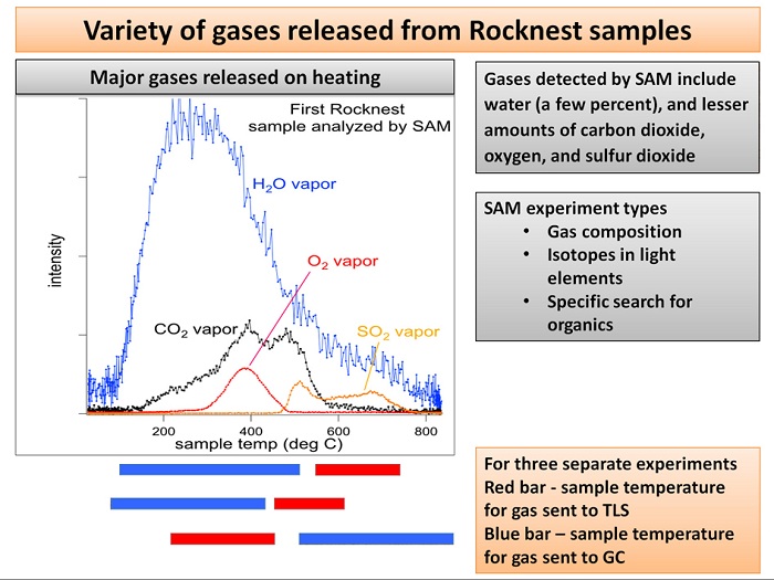
This plot of data from NASA's Mars rover Curiosity shows the variety of gases that were released from sand grains upon heating in the Sample Analysis at Mars instrument, or SAM. The gases detected were released from fine-grain material, and include water vapor, carbon dioxide, oxygen and sulfur dioxide.
SAM has three instruments for analyzing gas from samples heated to different temperatures: a quadrupole mass spectrometer (QMS), a gas chromatograph (GC) and a tunable laser spectrometer (TLS). Together, they are capable of obtaining the composition of gases; identifying different isotopes of lighter elements; and detecting organic, or carbon-containing, materials if present.
-
Inspecting Soils Across Mars
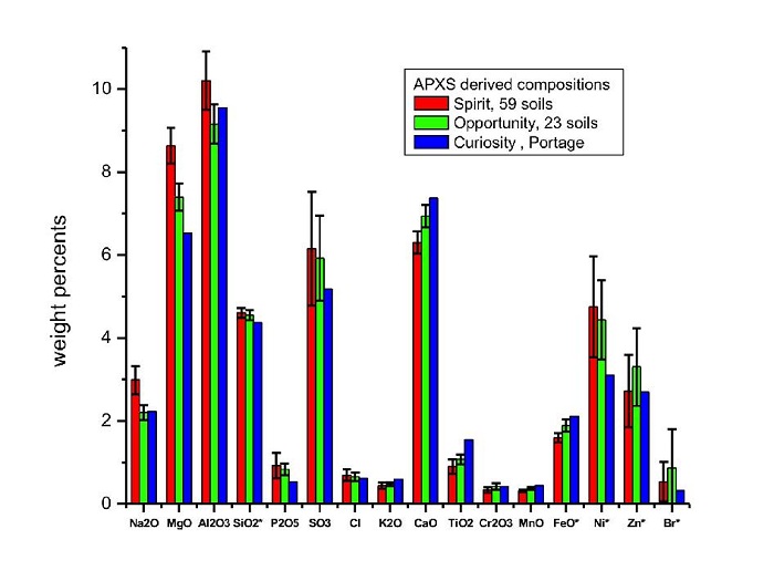
This graph compares the elemental composition of typical soils at three landing regions on Mars: Gusev Crater, where NASA's Mars Exploration Rover Spirit traveled; Meridiani Planum, where Mars Exploration Rover Opportunity still roams; and now Gale Crater, where NASA's newest Curiosity rover is currently investigating. The data from the Mars Exploration Rovers are from several batches of soil, while the Curiosity data are from soil taken inside a wheel scuff mark called "Portage" and examined with its Alpha Particle X-ray Spectrometer (APXS).
These early results indicate that the samples investigated by Curiosity are very similar to those at previous landing sites.
Error bars indicate the variations for the given number of soils measured for the Mars Exploration Rovers along the traverse. Note that concentrations of silicon dioxide and iron oxide were divided by 10, and nickel, zinc and bromine levels were multiplied by 100.
-
A Sampling of Martian Soils
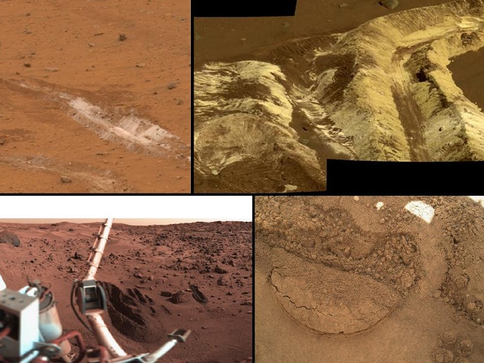
This collage shows the variety of soils found at landing sites on Mars. The elemental composition of the typical, reddish soils were investigated by NASA's Viking, Pathfinder and Mars Exploration Rover missions, and now with the Curiosity rover, using X-ray spectroscopy. The investigations found similar soil at all landing sites. In addition, the soil was usually unchanged over the traverse across the Martian terrain made by both Mars Exploration Rovers.
The Mars Exploration Rover Spirit's landing region in Gusev Crater is seen in both pictures at top; Viking's landing site is shown at lower left; and a close-up of Curiosity's Gale Crater soil target called "Portage" is at lower right.
In Gusev Crater, several white subsurface deposits were excavated with Spirit’s wheels and found to be either silica-rich or hydrated ferric sulfates.
-
Windblown Sand from the 'Rocknest' Drift
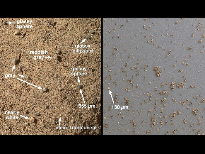
The Mars Hand Lens Imager (MAHLI) on NASA's Mars rover Curiosity acquired close-up views of sands in the "Rocknest" wind drift to document the nature of the material that the rover scooped, sieved and delivered to the Chemistry and Mineralogy Experiment (CheMin) and the Sample Analysis at Mars (SAM) in October and November 2012.
The picture on the left, acquired on the 58th Martian day or sol of the mission (Oct. 4, 2012), covers an area of about 0.75 by 0.87 inches (1.9 by 2.2 centimeters) and shows some of the variety of coarse sand grains observed on a portion of the Rocknest wind drift that was flattened by the left front rover wheel. Though Mars is thought of as the Red Planet, the sands of Mars are not necessarily red. This one small area shows clear, translucent grains, gray sand and white sand, in addition to two blue-gray glassy spheres and a glassy ellipsoid. The spherical and ellipsoidal grains were likely formed from molten droplets that cooled above the Martian surface to form glass, either during an explosive volcanic eruption or an impact cratering event. Similar grains are found in association with impacts on Earth and explosive volcanoes on the moon. The larger glassy sphere is 0.026 inches (655 micrometers) in diameter.
The picture on the right, acquired on Sol 73 (Oct. 20, 2012), shows a magnified view of the fraction of smaller sand grains examined by Curiosity. These are grains that were collected in the rover’s third scoop. They were passed through a sieving system in the Collection and Handling for In-Situ Martian Rock Analysis (CHIMRA) tool on the rover’s turret; only grains smaller than 0.006 inches (150 micrometers) passed through the sieves. In this image, the sieved grains are viewed on Curiosity’s approximately 2.9-inch-diameter (about 7.5-centimeter-diameter) observation tray; the image shown here covers a much smaller part of the tray, just 0.26 by 0.30 inches (6.5 by 7.6 millimeters). Many of these fine sand grains are angular pieces of crystalline minerals, ideally suited for analysis by the Chemistry and Mineralogy Experiment (CheMin).
-
Scoop Marks in the Sand at 'Rocknest'
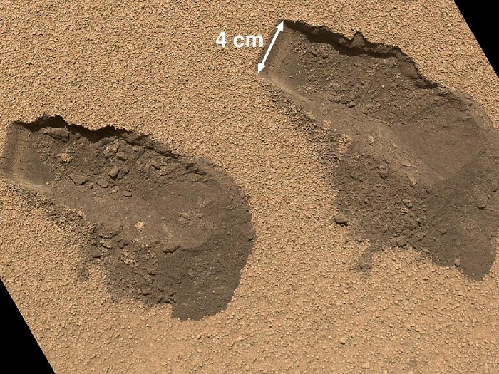
This is a view of the third (left) and fourth (right) trenches made by the 1.6-inch-wide (4-centimeter-wide) scoop on NASA's Mars rover Curiosity in October 2012. The image was acquired by the Mars Hand Lens Imager (MAHLI) on Sol 84 (Oct. 31, 2012) and shows some of the details regarding the properties of the "Rocknest" wind drift sand. The upper surface of the drift is covered by coarse sand grains approximately 0.02 to 0.06 inches (0.5 to 1.5 millimeters) in size. These coarse grains are mantled with fine dust, giving the drift surface a light brownish red color. The coarse sand is somewhat cemented to form a thin crust about 0.2 inches (0.5 centimeters) thick. Evidence for the crusting is seen by the presence of angular clods in and around the troughs and in the sharp, jagged indentations and overhangs on one wall of each trench (the walls closest to the top of this figure).
Beneath the crust surface, as revealed in the scoop troughs and the piles of sediment on the right side of each, is finer sand, which is darker brown as compared with the dust on the surface. The left end of each trough wall shows alternating light and dark bands, indicating that the sand inside the drift is not completely uniform. This banding might result from different amounts of infiltrated dust, chemical alteration or deposition of sands of slightly different color.
-
