
8.07.2023
Analysis of data from China’s Zhurong rover reveals more about early Mars weather systems
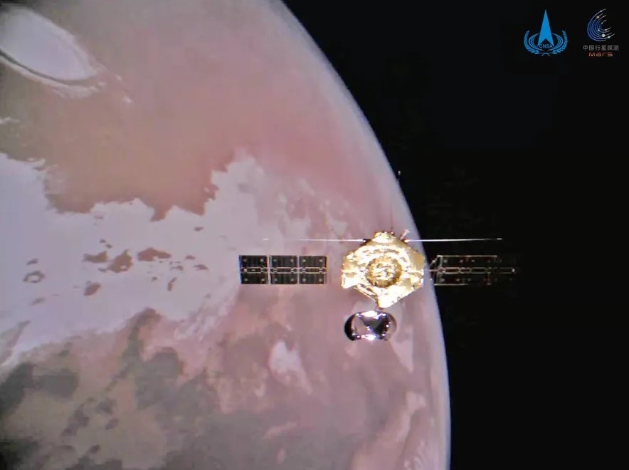
The Zhurong Mars rover, built and operated by the China National Space Administration (CNSA), has sent back data that suggests that Martian sand dunes were produced by a shift in prevailing winds after the planet’s last ice age.
Zhurong is examining dunes on the Utopian Planitia in Mars’s northern hemisphere, the largest recognised impact basin in the solar system with an estimated diameter of 3,300 km.
CNSA says the shift in prevailing winds took place about 400,000 years ago, coinciding with the end of the last glacial period on the Red Planet.
The results of the study are published in Nature. It was conducted by researchers from the National Astronomical Observatories (NAOC), Institute of Geology and Geophysics and Institute of Tibetan Plateau Research of the Chinese Academy of Sciences (CAS) in collaboration with scientists from Brown University in the US.
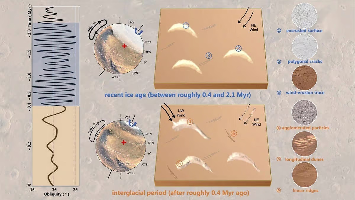
The Martian dune formation and Martian climate in the Zhurong rover exploration zone. Credit: NAOC.
They found prevailing winds changed direction nearly 70° from northeast to northwest.
The resulting erosion morphed the crescent-shaped dunes formed during the last glacial period on Mars into dark, longitudinal ridges after the ice age.
“The exploration and research on the climate evolution of Mars has been of great concern for a long time,” says senior author and principal investigator of the study Professor Chunlai Li from NAOC. “Mars is the most similar planet to Earth in the solar system. Understanding Martian climate processes promises to uncover details of the evolution and history of Earth and other planets in our solar system.”
It has long been suggested that the Martian climate has changed over time. But without scientists on the surface to directly measure and sample the local geology, giving a sense of these processes is difficult.
High-resolution orbital cameras and Zhurong’s terrain and multispectral cameras have given Li’s team access to surface composition analysis and meteorological measurement instruments taking data directly from the planet’s surface.
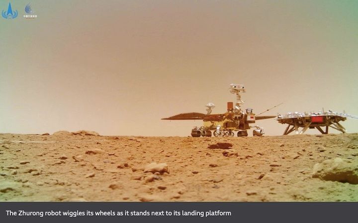
Zhurong landed on Mars in May of 2021. The 240-kilogram robot is analysing a relatively flat region in the southern part of the Utopian Planitia which might be the edge of an ancient ocean or lake. It is obtaining data in the region to help researchers build a picture of Martian environments and weather today and in its ancient past.
The analysis of the data occurred before the rover went into hibernation in May 2022, done to protect it from the harsh northern Martian winter.
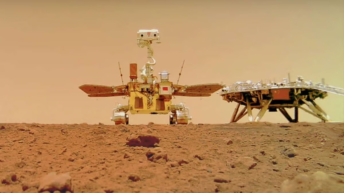
Zhurong rover group selfie with the Tianwen-1 lander, taken by the deployable Tianwen-1 Remote Camera. Credit: China News Service via Wikimedia Commons CC BY 3.0.
Unfortunately the rover didn’t wake up in December as scheduled, and CNSA is concerned that the rover became inoperable due to dust build up. There is a chance that active cleaning measures may revive the rover in July.
Nevertheless, the data already produced by Zhurong continues to reveal insights into Martian climate and geology.
In April, CAS researchers published a paper in Science Advances that revealed the first evidence of liquid water on Mars from observations made by the rover.
Scientists in China and internationally are engaged in efforts to understand climatic shifts on Mars over the course of the Amazonian epoch. This geological period on Mars began between 3.55 billion and 1.8 billion years ago and continues to this day.
“Understanding the Amazonian climate is essential to explain the current Martian landscape, volatile matter reservoirs and atmospheric state, and to relate these current observations and active processes to models of the ancient climate of Mars. Observations of the current climate of Mars can help refine physical models of Martian climate and landscape evolution, and even form new paradigms,” Li explains.
“We will continue to study both Amazonian and present-day climate to promote the knowledge regarding the last two billion years of Martian climate history, including its environment and processes.”
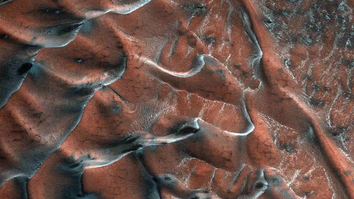
A field of sand dunes occupies this frosty 5-kilometre diameter crater in the high-latitudes of the northern plains of Mars taken by the Mars Reconnaissance Orbiter High Resolution Imaging Science Experiment. Credit: NASA/JPL-Caltech/University of Arizona.
Quelle: COSMOS
----
Update: 12.09.2023
.
China publishes new datasets obtained by Mars, lunar probes
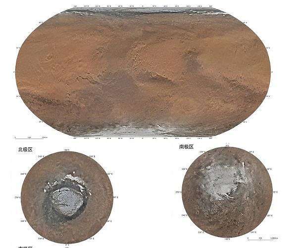
China's map of Mars.
China published two new batches of data on Monday, obtained by its Mars probe and lunar probe.
The scientific data obtained by three scientific payloads including a high-definition camera on Tianwen 1, the country's Mars probe, from January to March this year, have been released, amounting to nearly 68 gigabytes, according to the National Astronomical Observatories of the Chinese Academy of Sciences (NAOC).
This is the probe's fifth data release. Tianwen 1, consisting of an orbiter, a lander and a rover, entered the Mars orbit on Feb 10, 2021, becoming the country's first probe to orbit the planet.
Also, the NAOC team published the 38th scientific data acquired by four payloads mounted on the lander and rover of the Chang'e 4 probe between April 15 and June 24 this year. The data is sized at 2.7 gigabytes.
The Chang'e 4 probe, launched on Dec 8, 2018, made the first-ever soft landing on the Von Karman Crater in the South Pole-Aitken Basin on the far side of the moon on Jan 3, 2019.
Quelle: SD
----
Update: 26.11.2023
.
China's Mars rover detects irregular wedges beneath red planet
Radars mounted on China's Mars rover Zhurong detected 16 irregular wedges buried underneath a vast plain in the northern hemisphere of Mars.
A collaborative team led by the researchers from the Institute of Geology and Geophysics under the Chinese Academy of Sciences identified from the radar data the polygonal wedges below a depth of 35 meters within the rover's journey of approximately 1.2 kilometers, according to the study published on Thursday in the journal Nature Astronomy.
The study showed that the findings suggested a wide distribution of such terrain beneath Utopia Planitia, the largest basin on Mars.
Researchers proposed that the polygons were potentially generated by freeze-thaw cycles.
For polygons with diameters from centimeters to tens of meters, possible formation mechanisms may include contraction from dried-up wet sediments producing mud-cracks, contraction from cooling lava producing columnar jointing, faulting creating a jointing system in rock and thermal contraction cracking, according to the study.
Also, the contrast above and below about-35-meter depth represented a notable transformation of water activity or thermal conditions in ancient Martian time, implying that there was a climatic upheaval at low-to-mid latitudes.
The study also showed that drastic climate changes took place possibly due to the high obliquity of ancient Mars.
The findings point to more evidence for understanding the complex geological evolution and climate change of the red planet.
China's Tianwen-1 mission, consisting of an orbiter, a lander and a rover, was launched on July 23, 2020.
The lander, carrying the rover with an expected life span of at least 90 Martian days or about three months on Earth, touched down in the southern part of Utopia Planitia on May 15, 2021.
Quelle: Xinhua
----
Update: 13.01.2024
.
Massive Mars dust storm spotted by China's Tianwen-1 probe (photos)
An amateur space image processor spotted the dust storm near Olympus Mons.
China's Tianwen-1 Mars orbiter captured this stunning selfie above the Red Planet by jettisoning a small camera and beaming photos via WiFi to the mothership. (Image credit: CNSA/PEC)
China's Tianwen-1 orbiter spotted a massive dust storm on Mars near Olympus Mons, the biggest mountain in the solar system.
The massive dust storm was captured by the medium-resolution MoRIC camera on Tianwen-1 in January 2022. The mission launched in July 2020 and arrived in orbit around Mars just ahead of the arrival of NASA's Perseverance rover in February 2021.
An image of the storm was processed by Andrea Luck, using data from China's Lunar and Planetary Data Release System. Luck then shared the images on X. A larger version is viewable on Flickr.
A Chinese research team is developing methods to identify and assess sand and dust storms using MoRIC images, according to a journal article published in October last year.
Luck also processed a striking crescent Mars image of what is apparently the same storm near Olympus Mons, making the most of the fact there are several active orbiters around Mars. The image this time came from the UAE's Hope Mars mission probe.
The Tianwen-1 mission also included the solar-powered Zhurong rover. Its successful landing made China only the second country to operate a rover on the Red Planet.
Zhurong completed its primary mission and went on to conduct extended exploration activities in the large plain of Utopia Planitia. It entered hibernation in May 2022 and was expected to reawaken in December that year.
However, China has been unable to make contact with the rover since its hibernation. It is thought that the vehicle's solar arrays became covered with more Martian dust than expected, rendering it unable to generate the power necessary to reactivate.
Quelle: SC
----
Update: 9.11.2024
.
Chinese rover helps find evidence of ancient Martian shoreline
With the assistance of China's Zhurong rover, scientists have gathered fresh evidence that Mars was home to an ocean billions of years ago - a far cry from the dry and desolateworld it is today.
Scientists said on Thursday that data obtained by Zhurong, which landed in the northern lowlands of Mars in 2021, and by orbiting spacecraft indicated the presence of geological features indicative of an ancient coastline. The rover analyzed rock on the Martian surface in a location called Utopia Planitia, a large plain in the planet's northern hemisphere.
The researchers said data from China's Tianwen-1 Orbiter, NASA's Mars Reconnaissance Orbiter and the robotic six-wheeled rover indicated the existence of a water ocean during a period when Mars might already have become cold and dry and lost much of its atmosphere.
They described surface features such as troughs, sediment channels and mud volcano formations indicative of a coastline, with evidence of both shallow and deeper marine environments.
"We estimate the flooding of the Utopia Planitia on Mars was approximately 3.68 billion years ago. The ocean surface was likely frozen in a geologically short period," said Hong Kong Polytechnic University planetary scientist Bo Wu, lead author of the study published in the journal Scientific Reports, opens new tab.
The ocean appears to have disappeared by approximately 3.42 billion years ago, the researchers said.
"The water was heavily silted, forming the layering structure of the deposits," Hong Kong Polytechnic University planetary scientist and study co-author Sergey Krasilnikov added.
Like Earth and our solar system's other planets, Mars formed about 4.5 billion years ago. At the time the ocean apparently existed, it might already have begun its transition away from being a hospitable planet.
"The presence of an ancient ocean on Mars has been proposed and studied for several decades, yet significant uncertainty remains," Wu said. "These findings not only provide further evidence to support the theory of a Martian ocean but also present, for the first time, a discussion on its probable evolutionary scenario."
Water is seen as a key ingredient for life, and the past presence of an ocean raises the prospect that Mars at least at one time was capable of harboring microbial life.
"At the beginning of Mars' history, when it probably had a thick, warm atmosphere, microbial life was much more likely," Krasilnikov said.
The solar-powered Zhurong, named after a mythical Chinese god of fire, began its work using six scientific instruments on the Martian surface in May 2021 and went into hibernation in May 2022, likely met with excessive accumulation of sand and dust, according to its mission designer. It exceeded its original mission time span of three months.
Researchers have sought to better understand what happened to all the water that once was present on the Martian surface. Another study, published in August and based on seismic data obtained by NASA's robotic InSight lander, indicated that an immense reservoir of liquid water may reside deep under the surface within fractured igneous rocks.
Quelle: Reuters
1377 Views