

29.09.2020
America’s wildfire and hurricane seasons have both smashed records in 2020, with months left to go.
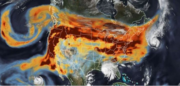
Smoke meets cyclones in a jarring new series of satellite images posted to NASA's Earth Observatory website.
In the images, which combine recent observations of the United States taken by several different NASA satellites from Sept. 14 to 16, orange-tinted smoke from an immense series of wildfires on the West Coast sails clean across the country to collide with tropical cyclones on the other side.
One image, from Sept. 15, shows the two weather catastrophes directly interacting, as churning winds from Hurricane Paulette literally block wildfire smoke in the upper atmosphere from flowing further into the Atlantic Ocean. Meanwhile, Hurricane Sally — bearing down on the Gulf Coast at the time — pushes the smoke plume further north. When Paulette dissipated the following day, the smoke continued its eastward journey over the ocean.
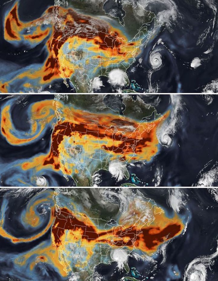
These composite pictures clearly paint the intensity of the ongoing hurricaneand wildfire seasons battering North America, both of which have already made history.
Wildfires in California have already burned more than 3.6 million acres (1.4 million hectares) of land as of Sept. 21, nearly doubling the previous all-time record of 1.9 million acres (768,000 hectares) set in 2018, according to Cal Fire, the state government's firefighting agency. Six of the state's top 20 largest fires have occurred this year, the agency reported, and some smoke plumes rose more than 10 miles (17 kilometers) into the air — another fire record in North America. And wildfire season isn't even over yet.
The 2020 Atlantic hurricane season has been so active, the government has literally run out of names for new storms. On Friday (Sept. 18), Tropical Storm Wilfred became the 23rd named storm of the season, exhausting the official, alphabetical list of names for the year. With months left to go in the season, the NHC has moved to Greek letters for the next 24 named storms. Tropical Storm Alpha formed near the coast of Portugal later on the same day. Meanwhile, Tropical Storm Beta is strengthening and is predicted to hit the Gulf Coast today (Sept. 21).
Both the record wildfire and hurricane seasons have been exacerbated by ongoing global climate change, according to climate researchers. Here's how climate change is making wildfires and hurricanes more intense every year.
Quelle: SC